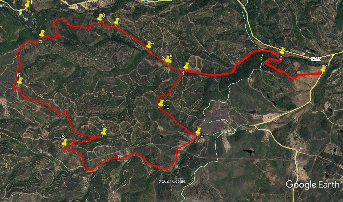
Walk Fifty Nine. Rasmalho. 17.2k Ascent: 650 metres.
GPS: 37/ 13 19 17 8/ 32 37 34 (Casa de Pasto Riba e Serra.)
A walk from just north of the linear village of Rasmalho, strung out along the N266 road between Portimao and Monchique. The route is all on clear tracks, after an initial low/level wander alongside a stream, with no extreme climbs or descents. There are excellent views from the high points.
Getting to Rasmalho.
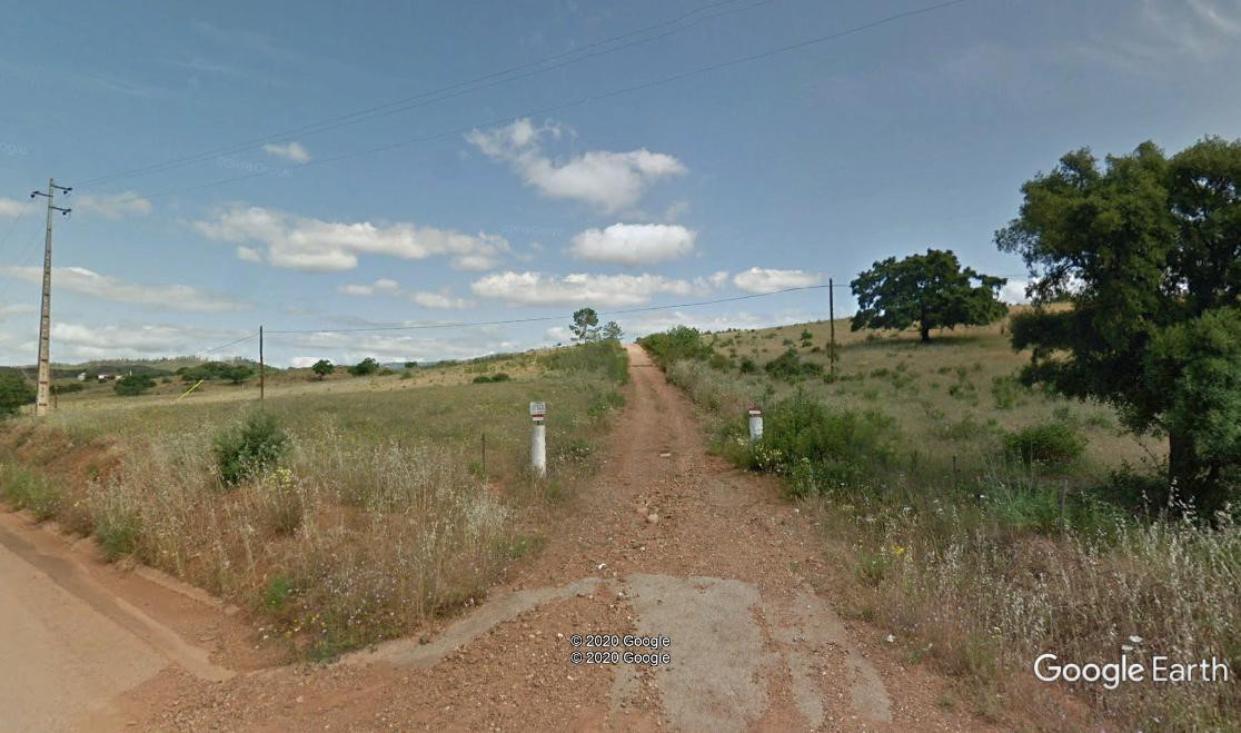
Take either the A22 motorway to the Portimao/Monchique exit, and follow signs to Monchique. Go through the hamlet of Porto do Lagos and take the N266 at a roundabout, signed to Monchique. Pass a petrol station and a set of traffic lights, and shortly find a small café/restaurant on the left, Casa de Pasto Riba e Serra, where you can get refreshment or meet your group. This is the GPS reference above. To reach the start-point of the walk, drive on past the café for 1.7 kilometres. Find a turn on the left immediately after a bus-stop, with a sign to restaurant ´O Cacador´ just beyond it. Turn here, cross a bridge and park just after it.
The Walk
The first hill.
- From your parking space, walk up the road, and take the first turn right, on a rough track going uphill, west of north. After 470m, it swings round to due north,
still climbing slowly. After a further 470m, swing round sharply to the right and descend. 240m further on, swing round sharply to the left and drop down to join
another track (2) Turn left
- Follow the track going north. Starting north-easterly, it turns due north before resuming a northeasterly course. After almost 2k, pass a single building on the right (3)
- Ignore tracks leading off left and right and follow the main track as it begins to climb steadily, just east of north. Ignore a further turn to the right followed shortly by one to the left, and arrive at a high point at a junction, after a further 1k (4)
- Bear left here and follow northwards for around 360m along more or less level ground, after which the track begins to rise again. (Across the valley ahead and right, see a large glass and steel building, hotel health spa complex. The village and spa of Caldas de Monchique lies below it in a deep valley.) Rising by stages with short dips, the path swings round in a wide curve to head south-west for a time before rounding a hairpin, peaking and levelling out, now heading north-west. Arrive at a junction with a track coming in from the right. (5) (1.67k from 4)
- Continue ahead as the track swings round more westerly, still rising, passing a very steep uphill dirt track on the right after 370m. A further 130m on, find a track leading downhill on the left, and take it. Over the next 620m, it quickly turns right and undulates westerly for a time before rising again to a new high point at a T junction with a broad track. Turn left, and follow this south-east for around 100m, when it swings sharply right. (6)
- Now descend steadily into a valley, heading first south-west and then due south, over 840m. At this point the track curves to the left, with a derelict building on the left, and rises a little to round a sharper bend to the right before resuming a south-westerly direction then due south again, over the next 750m. Cross a small stream (or dry bed) towards the end of this distance, and after a further 100m, look for a rather insignificant track heading back at a sharp angle on the right. (7)
- Take this track, heading NNW, which starts off grassy but soon turns into a clear dirt-track, heading quite steeply uphill. Pass one track coming in from the left after 240m and another leaving downhill on the right by a building, 150m further on. After another 100m look for a track on the left, turning through a hairpin bend, and take it, rising a little before levelling out. Another 100m on arrive at a multi-way junction. Take the second on the right round another hairpin, then ignore a fork to the right 100m late and proceed to a hairpin bend at the top of the rise. (8)
- Swing round left and descend once more into a valley, due south then south-west, turning left at a junction with a wide dirt road after 500m, buildings visible in the valley in front. Now walk along the valley road seeing increasing signs of habitation and cultivation on the right. Pass the entrance to a newly renovated villa up on the left and continue. Around 2.1 kilometres after joining the wide road, arrive at a point where the valley opens up on the left, with a house on the hill above left, a sandy area ahead off the road, and a track going down to the stream on the right. (9)
- There are three tracks on the left here. Take the third one, a green track running on level ground north-westerly. After running level for a time, it begins to rise by stages, becoming rather uneven underfoot. Arrive at a junction after 700m where the track forks in front of a hill, and take the right hand. (10)
- Follow this slightly overgrown track as it climbs and curves round to the right to emerge at a T junction on a ridge after 280m. Turn right and then first left to descend on another rather rocky and weed-strewn track, which leads straight down to the valley, and joins your outward track a little way south of point 3 after 540m. (11) Turn right to retrace your steps past the river crossing junction and through the overgrown meadows back to your car. (2.47k)
Orientation: Left is north. 37/8
GPS Points:
| 1 | Start | 14 | 14 | 73 | 32 | 52 | 27 | |||
| 2 | Wider track | 14 | 37 | 27 | 32 | 50 | 52 | 800m | ||
| 3 | Building | 15 | 29 | 98 | 33 | 18 | 47 | 1.95k | ||
| 4 | High point fork | 16 | 00 | 68 | 33 | 06 | 34 | 1k | ||
| 5 | Track from right | 16 | 33 | 15 | 33 | 28 | 38 | 1.67k | ||
| 6 | Right turn | 16 | 35 | 50 | 34 | 00 | 25 | 1.18k | ||
| 7 | Hairpin after stream | 15 | 49 | 49 | 34 | 14 | 13 | 1.68k | ||
| 8 | Hairpin | 16 | 05 | 42 | 34 | 27 | 36 | 600m | ||
| 9 | Turn off wide track | 15 | 05 | 33 | 33 | 55 | 71 | 2.65k | ||
| 10 | Right fork | 15 | 27 | 16 | 33 | 46 | 30 | 700m | ||
| 11 | Main track | 15 | 20 | 76 | 33 | 18 | 74 | 550m | ||
| End | 3k |