Walk Fifty Eight. Raposeira – Pedralva. 25k Ascent: 300m
GPS: 37/ 04 56 31 8/ 53 23 74
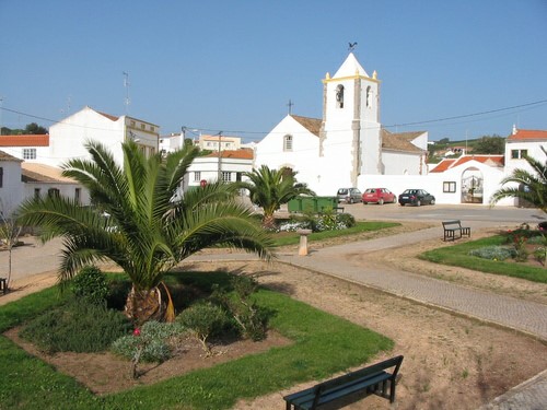
Perhaps the longest walk in the series, but by no means the most difficult, as the terrain is generally quite flat. It covers a swathe of land to the north-east of the village of Raposeira, which lies astride the main N125 not far from the small town of Vila do Bispo, on the way to the most south-westerly point in Europe at Cabo de São Vicente (Cape St Vincent.). One of the main attractions of the area is the plethora of prehistoric standing stones which litter the low moorlands. You need an expert to show them to you and interpret the scratches upon them. The walk takes in the attractive village of Pedralva, which is now almost completely given over to holiday lets, and where there is a (quite expensive) bar and restaurant. This walk was devised and led by Antje Whittle for the AWW.
Getting to Raposeira.
One of the easiest starting-points to find. From Lagos and all points east take the N125 towards Vila do Bispo. (From the A22 come off at the Lagos/Vila do Bispo exit and turn right at the 125.) Drive for around 20k, past Luz and Budens, and arrive at Raposeira down a hill, with traffic lights. (The lights along the 125 are steadily being replaced with roundabouts, so this may change). Turn right at the lights and park where you can. There is a café on the right here.
The Walk
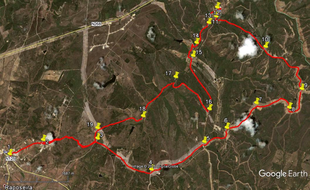
- If you wish to shorten the walk by 2k, you can drive up to point 2 and park there. To walk, (1) cross the main road at the lights and head up into the main part of the village. After 200m swing right onto the Rua Primeiro de Maio and follow this as it climbs up and out of the built-up area, heading north-east. Around 1k from the traffic lights arrive on level ground at a small roundabout by a new housing development. (2). (the extent of development will have depended on the economic climate). Go straight on here and take the left fork soon after to pass to the left of a row of houses. The road begins to curve to the left and turns into a dirt-track.
- About 360m from 2, on the crown of the curve, find a track leading off north-eastwards and follow it as it descends into a valley to cross a water-course at the bottom after 400m. It then climbs about the same distance up to a wind turbine. Follow the wide track past two more turbines to reach a junction after a further 540m (3). Turn right here and walk more or less due east for 1.73k to another junction. (4). Here turn half-left to head off north-east, still on level ground, for a further 1.69k, to yet another junction (5).
- Go straight across here and walk for the next 860m through a more wooded area, with land sloping away to the right. Coming to a junction with a track coming in from the right, bear left and quickly arrive at a fork. (6). Take the right-hand option and follow the track, now on more of a ridge, descending a little, for a further 1.13k, to find another track coming in from the left. (7) Stay right and follow round a right-hand bend then continue north-east for some 700m, descending a little then rising again, to reach a wider right-hand curve, arriving at yet another junction, 1.23k from 7. (8). Turn left here and follow the ridge around as it moves from south-east to north-east to north-west, arriving at a further junction after 760m. (9) Bear left at the fork here and continue north-west for a further 730m, when the track veers round due west. Ignore turns to the right over the next 1.13k, to come to a fork right, with a turn to the left more or less opposite. (10). Go straight on here, maintaining the general westerly course, over the next 1.66k (descending after 600m), to reach a junction (11). Turn right.
- After 230m, the track becomes a tarmac road. The village ahead is Pedralva. If you are very anxious for lunch or a drink, you can turn left here and find the bar/restaurant on the right very soon. To see the pretty village, go on to the next junction and turn left to double back through the houses to the bar. (12) (500m from 11, the long way round.)
- To continue the walk, head south-east from the bar, running roughly parallel with the road you walked in on. After 530m come to a cross-tracks where you could go onto the main track. (13) Otherwise go across and continue for a further 710m to a fork (14). Take the right hand round a bend to face north-west, then turn first left to continue the southerly course. Finally turn left to join the main track , 580m from 14. (15). Walk along the road for 1.67k, climbing steadily. After a broad right-hand curve, take the second on the right at a cross-tracks, (16) now starting to descend on a ridge. After around 1.4 k, the track makes a wide turn to the right and comes down to a junction in a valley (17).
- Turn left and walk steadily uphill for 1.44k, going south, to reach a junction with the dam wall of a small barrage visible ahead and right. (18). Turn right and after 310m go straight ahead south-west at another junction with a track from the right. Walk for a further 1k in this direction, towards a wind turbine, and turn left in front of it (19). Walk on past another turbine on the left to reach a junction. You are now back at Point 3. Take the first right to walk back past the other turbines and across the open land, down through the valley and up to the track near the new housing development. Turn left to reach the tarmac road at Point 2, (1.7k from 3 and either pick up your transport here or walk back down the hill into Raposeira.
Orientation; Left is south-west.
GPS Points:
| 1 | Raposeira | 04 | 56 | 08 | 53 | 23 | 74 | |||
| 2 | New houses | 05 | 23 | 78 | 53 | 01 | 28 | 1k | ||
| 3 | After turbines | 05 | 51 | 90 | 52 | 12 | 64 | 1.7k | ||
| 4 | Junction 1 | 15 | 56 | 75 | 51 | 04 | 58 | 1.73k | ||
| 5 | Junction 2 | 06 | 41 | 89 | 50 | 33 | 71 | 1.69k | ||
| 6 | Junction 3 | 07 | 03 | 05 | 50 | 21 | 76 | 860m | ||
| 7 | Junction 4 | 07 | 35 | 40 | 50 | 10 | 21 | 1.13k | ||
| 8 | Junction 5 | 07 | 48 | 33 | 49 | 37 | 42 | 1.23k | ||
| 9 | Junction 6 | 08 | 08 | 01 | 49 | 37 | 68 | 760m | ||
| 10 | Fork | 08 | 20 | 87 | 50 | 36 | 40 | 1.84k | ||
| 11 | Track to tarmac | 08 | 19 | 45 | 51 | 40 | 09 | 1.66k | ||
| 12 | Pedralva | 08 | 26 | 68 | 51 | 44 | 72 | 500m | ||
| 13 | Cross-tracks | 08 | 11 | 19 | 51 | 42 | 76 | 530m | ||
| 14 | Fork | 07 | 50 | 36 | 51 | 41 | 76 | 710m | ||
| 15 | Join main track | 07 | 38 | 99 | 51 | 36 | 66 | 580m | ||
| 16 | Turn off main track | 07 | 08 | 13 | 50 | 49 | 10 | 1.67k | ||
| 17 | Bottom of descent | 07 | 15 | 17 | 51 | 39 | 40 | 1.6k | ||
| 18 | Turn nr barragem | 06 | 30 | 25 | 51 | 44 | 88 | 1.44k | ||
| 19 | At turbine | 05 | 59 | 33 | 52 | 19 | 17 | 1.31k | ||
| Back to point 3 | 290m | |||||||||
| Back to point 2 | 1.7k | |||||||||
| End | 1k |