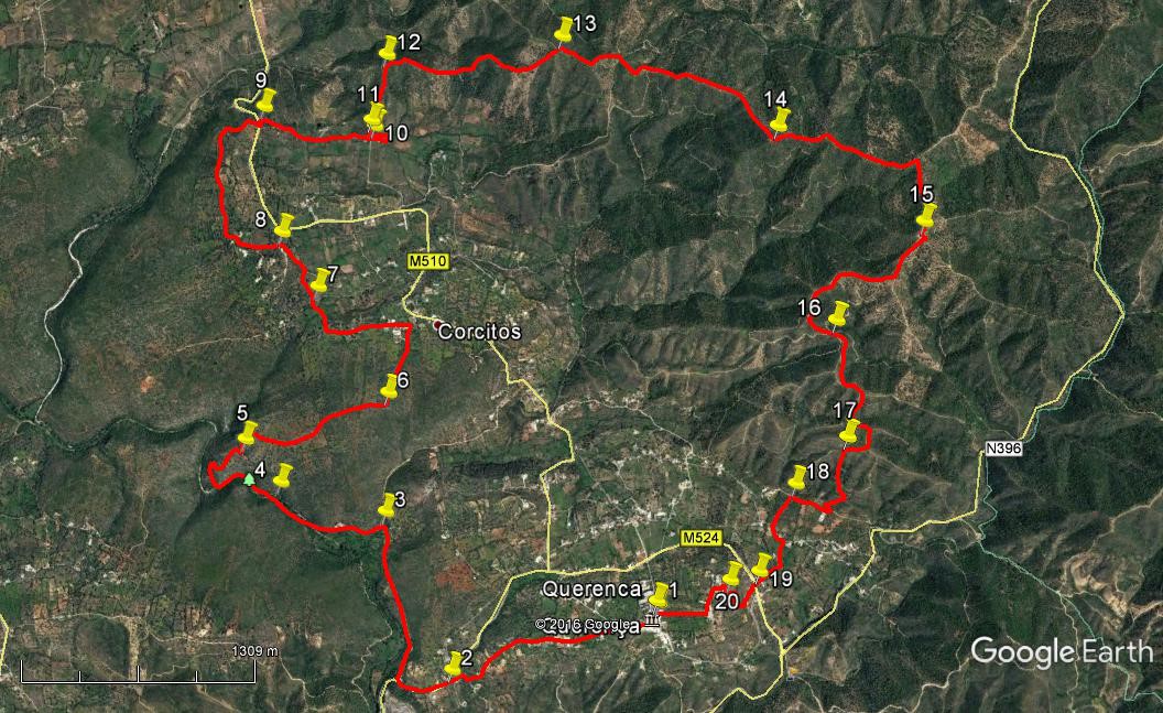
Walk Fifty Six Querença. 17.5 kilometres. Ascent: 680 metres.
GPS: 37/ 11 56 26 7/ 59 14 92
A fairly tough walk, primarily because of the climb to the high ridge in the second half, and the nature of the ridge itself, which has a number of ascents and descents along its length. Spectacular views from the highest points. The walk starts and ends in the attractive hilltop village of Querença, where there is a bar and two restaurants. There are no other refreshments on route.
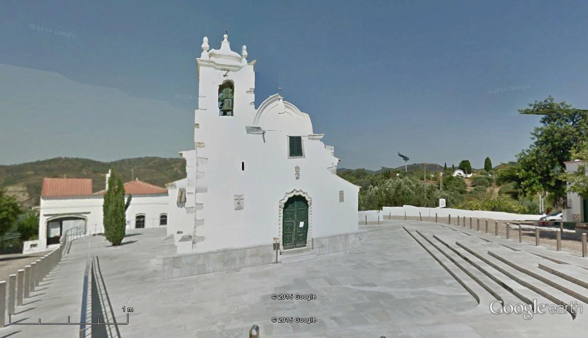
The church at Querença.
Getting to Querença
From the west and south, take the Loule Centro exit from the A22 and drive towards Loule, then following signs to Sao Bras. Drive round the Loule bypass, and reaching a roundabout at a large sports centre on the left, turn left. This road will take you all the way to Querenca. Drive round Querença when you reach it, taking the second tarmac turning uphill into the village – this is on the north side. Find a large car park on the right as you go up the hill. To reach the village square and refreshments you need to climb to the top of the hill.
From the east, drive up the N2 to Sao Bras. Turn left along the bypass, and just after the road becomes single carriageway, take the first turn on the right uphill. This road will take you to Querença. Then follow the instructions above.
The Walk.
- Start from outside the bar opposite the church. (1) Facing the church, turn right and take the first turn on the right by the Junta de Freguesia – the council office. Follow this narrow road, taking the left fork in front of a small chapel after 240m. After 1k, walking due west and then a little more south-west, come down to a junction with another tarmac road – see a stone column ´Caminho de Portela´at the junction. Turn right, going round a left-hand bend to join a wider road coming in from the right after another 130m. (2) Turn left down this road, and then take the first turn on the right, onto a sandy area with an information board after 330m. This track leads you to the Fonte de Benémola, a local picnic spot with a spring that rarely dries up.
- Walk along the first part of the track for 990m, ignore a track leading off uphill on the right near the end of this stretch and come to a junction, turning left (3). Walking along by the stream now, you will come to the Fonte after 490m, marked by picnic benches. Continue past it. You will see, after a further 220m, a narrow rocky path leading off uphill. (4) Taking this will lead you up a rocky climb, past some cave entrances (do not try to enter) and up to a wider track after 320m. This is not the track marked on the Google photo. The top of this rocky path is marked as point (5). To follow the marked track, continue along the valley until the track begins to climb steeply, swinging round to the right to reach point 5 after 850m.
- Reaching level ground, follow the track over a broad flat area of scrub and bushes. After 1k turn through 90 degrees left (6) to walk a further 480m up to a group of houses. This is the hamlet of Corçitos. Past the first house come to a junction and turn left, following the narrow tarmac road east down into a valley for 480m, turning north with the road as it starts to climb again. Ignore a turn to left and come to another one the right after a further 210m (7). Go straight ahead on level ground as the road becomes a gravel track and comes to a junction after 180m. Turn left here and go very gently uphill to another junction near Cerro da Corte after a further 220m (8), with a tarmac road over to the right. Turn left and immediately swing right here (footpath signs at the side) to walk on level ground. Just before a sharp turn to the left after 220m with a house on the corner, bear right on a dirt track which soon curves left and then turns right to run due north along a low ridge.
- At the end of the ridge the path turns right and drops down to a tarmac road, with a turn to the right on tarmac almost opposite the point where you meet it. (1.19k from 8) (9). Turn along this road and walk for 670m until it turns sharp right, with a house ahead and below (10). Walk straight on past the house and around the edge of the field left of it, turning to face the way you have come. When past the cultivated area, 270m from point 10, look for a path going uphill on the right (11) and climb the steep slope northerly through light scrub and bushes to reach a ridge after 410m (12). Turn right, easterly, and walk first of all on level ground and then rise to a high point at a junction after 1.1k. (13). Turn right once more and descend steadily 200m south-east and then 160 eastwards, to reach a five-way junction. .
- Take the second on the right and walk on level ground for a time, south-east, before starting to rise again to reach a second high point after a further 1.1k (14). Follow the ridge line south-east on level ground once more, and take a right turn across a saddle after 870m dipping slightly before climbing steeply, due south, (ignore a fork left as you start the steep climb) to reach the highest point of the ridge with a trig pillar on top after a further 420m. (15).
- Swing left to the trig and then immediately take the first right as the track starts to descend south-westwards. A track comes in from the left, then take the right hand at a fork after 220m. After heading west then north-west over 320m, the track describes a wide semi-circle to the left over the next 500m, ending facing south-east at a cross-tracks (16). Go straight across, and at a fork after 100m take the left hand path. Stay left again at the next fork after 120m, heading almost due south, then swing left after a further 180m, with tracks coming in from the right below. Another 100m further on, bear right at a fork to begin descending quite steeply. On this descent, swing left after 180m, then right after 100m, then right again after 100m, then left again after 130m, (17) to descend very steeply into the valley. After a couple of sharp bends near the bottom, arrive at a dirt road in the valley, almost opposite a large house after 450m.
- Turn right past the house and take the first turn on the left after 250m (18), another dirt road, further down to the valley floor. Come to a junction with a tarmac road after 210m and turn left. At the next junction after 130m turn right, still on tarmac, and follow this road across the valley and up to a large house on the right at a junction with a main road after a further 330m. (Road name ´Caminho da Corte Garcia´ on the left). (19). Cross the road diagonally, and find a narrow footpath heading southwest up the hillside. After 140m it swings round to the right, runs north for a short distance and then northwest to reach an area of open land, more or less on level ground after a further 190m. (20) Walk diagonally across to the right, then swing round left and walk due north to arrive at a tarmac drive. Turn left and left again at a junction. Walk along to the corner of Querenca cemetery, along by the wall and turn right at the junction with the road leading to the main gate. Follow this straight avenue back to the centre of Querenca and the bar 590m. Your car is down the hill on the right.
Orientation normal. 37/ 7
GPS Points.
| 1 | Querenca | 11 | 57 | 08 | 59 | 14 | 38 | |||
| 2 | Main Road | 11 | 52 | 57 | 00 | 04 | 87 | 1.37k | ||
| 3 | Turn to Fonte | 12 | 24 | 00 | 00 | 12 | 00 | 1.32k | ||
| 4 | (Narrow path) | 12 | 33 | 73 | 00 | 34 | 33 | 710m | ||
| 5 | Narrow path route | 12 | 42 | 94 | 00 | 39 | 45 | 350m | ||
| Main path route | 850m | |||||||||
| 6 | Turn NE | 12 | 45 | 50 | 00 | 04 | 44 | 1k | ||
| 7 | Valley junction | 13 | 07 | 41 | 00 | 15 | 05 | 1.18k | ||
| 8 | Cerro da Corte | 13 | 18 | 54 | 00 | 20 | 12 | 400m | ||
| 9 | Tarmac crossing | 13 | 41 | 95 | 00 | 18 | 00 | 1.19k | ||
| 10 | In front of house | 13 | 34 | 09 | 59 | 54 | 11 | 670m | ||
| 11 | Bottom of climb | 13 | 35 | 26 | 59 | 54 | 52 | 270m | ||
| 12 | Top of climb | 13 | 45 | 68 | 59 | 47 | 34 | 410m | ||
| 13 | High Point 1 | 13 | 41 | 02 | 59 | 07 | 35 | 1.1k | ||
| 14 | High point 2 | 13 | 16 | 42 | 58 | 24 | 71 | 1.46k | ||
| 15 | Trig point | 12 | 53 | 92 | 57 | 58 | 13 | 1.30k | ||
| 16 | Turn on descent | 12 | 40 | 26 | 58 | 21 | 04 | 1.04k | ||
| 17 | Steep descent | 12 | 19 | 18 | 58 | 24 | 21 | 960m | ||
| 18 | Turn across valley | 12 | 12 | 47 | 58 | 37 | 37 | 700m | ||
| 19 | Main road | 11 | 58 | 13 | 58 | 50 | 05 | 670m | ||
| 20 | Top of climb | 11 | 58 | 20 | 58 | 57 | 25 | 330m | ||
| End | 590m |