Walk Fifty Two. Parizes Valleys. 21 kilometres Ascent: 850 metres.
GPS: 37/ 14 51 94 7/ 51 09 15
A long, quite demanding walk in the hills and valleys south of the small village of Parizes, east of Barranco do Velho. It can easily be divided into two, as the route describes a large figure of eight. The area is remote and there are no refreshments on route other than at Parizes itself. There is ample evidence of the depopulation that has taken place in these hills over many decades, with two more or less deserted villages lying on the route.
Getting to Parizes.
From the west, use the N124, picking it up at Silves, Messines, Benafim or Salir, to climb the winding road to Barranco do Velho. At the junction of the 124 and the N2 at the southern end of Barranco, turn right, and then take the first left, signed to Javali. At the next tarmac T junction turn left and follow this road all the way to Parizes.
From the south, take the N2 north from São Brás de Alportel to Barranco do Velho. Turn right along the Javali road just before the junction with the N124, and follow as above.
On the main road through the village, come to a turn to the left with an information board and bus stop, and a tiled fonte (well) on the opposite side. Park where you can close to this spot.
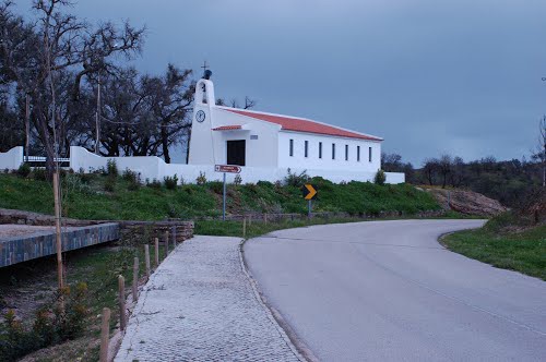
Chapel at Parizes
The Walk.
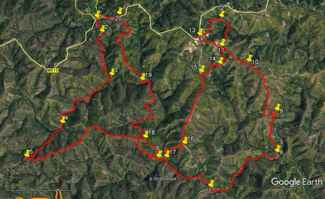
- Begin by walking up the narrow road left of the fonte. (1) This leads over a low rise and round a gentle right hand curve, (stay left at a fork after 130m) after which the tarmac ends at some houses. (2) Go straight ahead, passing to the left of the houses, to swing round to the right on a dirt track, leading up to a junction with a wider track after 150m. Turn left here and start a long winding walk down into the valley, heading more or less due south. After around 820m the track curves round the end of a slope (3) to run southwest on more or less level ground before starting to climb through two right and two left turns to reach a fork after 1.33k (4). Here take the left hand, heading southwest to climb further, and meet a track coming in at a sharp angle from the left after a further 820m (5). Turn sharp left to join this track and climb gently up a ridge before descending briefly (700m ENE), then climb again over 370m NE.
- Reaching a high point, the track curves round to continue southeastwards and begins a long descent. After 700m go round a sharp little bend and now continue due south and then southeast again, round a couple more bends to reach a junction at the valley floor after a further 790m. (6) Go across here due east and after 130m turn right to cross the stream running through the valley. NOTE: This is also Point 17. To cut the walk short and return to Parizes, follow the instructions from that point. Now head south and soon southeast again along the valley, roughly following the line of the stream, to come to a T junction after 740m. Turn right once more and after 280m reach a cross tracks (7), where you go straight across and then walk more or less east for 300m, then turn north-east and wind along the valley, descending slightly once more, to cross the stream again. Curve round to the left and go straight across at the next cross tracks (1.48k from 7) (8).
- Soon start to climb now as the track tends more or less due north, with a valley to the right and higher ground left, winding up to a small settlement with only one or two inhabited properties. (850m)(9) This is the hamlet of Fronteira. Past the houses, go left round a hairpin bend and soon swing round to north, climbing steadily all the time, in a fairly straight line. After around 860m start to veer more to northwest, arriving at a five-way junction after a further 390m, (10) but stay northwest on the main track for a further 540m. At the second clear turn to the left after this, (11) there is a choice to make. On the photo, you will see the little loop from point 11, going round to return to the same point. You can choose to cut this out by turning left and walking to point 14 and on.
- To walk the loop turn right at point 11, leaving a house on the left, to walk down into a charming tree-filled valley. Stay due north as the path winds through, and come up out of the trees for a short climb north-west to the end of a road by a farm after 590m (12) Follow the road as it winds uphill to reach a junction with a main road at the settlement of Cabanas. Turn left and then left again at the next exit (690m) (13), down a tarmac lane. Go down for 450m to get back to point 11 and turn right on tarmac to descend steadily.
- Pass some ruins on the roadside on the left and as you round the corner, take a path off to the right going downhill, ahead of a small white building on the right. 360m (14) The path curves to the right, then round quite sharply left after 150m, crossing a valley. Come to a fork after another 140m and take the right hand lane, leading to a much wider track at a T junction 200m further on. (15) Turn left. The track rises for around 180m, then descends more or less south-west for 1.1k in a straight line down a ridge. At the end of the ridge the track divides (16). Take the right hand, narrower, option and follow it down a winding course to the valley floor. (550m (17) Cross the stream. You are now at a point you reached earlier, between points 6 and 7.
- Turn sharp right (due north) and follow a narrow path immediately alongside the stream. Going due north at first, where the stream begins to curve to the left after around 370m find a narrow path leading off uphill to the left, and walk up this to pass by the ruins of another small settlement, Varzea do Velho – this one totally abandoned. Reach a wider track beyond the ruins after 290m and turn right. (18) From here you have a single track all the way back to Parizes. First go north, then swing round quite a sharp right hand bend to face east, then resume a generally northward path, although the way does wind quite a lot. Simply follow the wide track for a little over 3 kilometres as it tends uphill, passing through (19) at a hairpin bend after 1.55k, and arriving at the main road east of Parizes (1.6k) (20). Turn left to walk back to the village and your car. (390m)
Orientation normal. 37/ 7
GPS Points.
| 1 | Parizes | 14 | 51 | 94 | 51 | 09 | 49 | |||
| 2 | Right turn | 14 | 43 | 79 | 51 | 06 | 53 | 270m | ||
| 3 | Turn SW | 14 | 20 | 46 | 51 | 01 | 68 | 820m | ||
| 4 | Fork left | 13 | 56 | 30 | 51 | 35 | 65 | 1.3k | ||
| 5 | Hairpin left | 13 | 39 | 83 | 51 | 57 | 90 | 820m | ||
| 6 | Valley | 13 | 35 | 46 | 50 | 32 | 97 | 2.83k | ||
| 7 | Cross tracks | 13 | 18 | 81 | 50 | 00 | 04 | 1.15k | ||
| 8 | Cross tracks | 13 | 34 | 53 | 49 | 13 | 59 | 1.48k | ||
| 9 | Fronteira | 13 | 56 | 59 | 49 | 12 | 00 | 850m | ||
| 10 | 5-way | 14 | 23 | 07 | 49 | 29 | 62 | 1.25k | ||
| 11 | Turn to loop | 14 | 32 | 27 | 49 | 46 | 75 | 540m | ||
| 12 | After valley | 14 | 48 | 44 | 49 | 45 | 45 | 590m | ||
| 13 | Cabanas | 14 | 38 | 42 | 50 | 01 | 16 | 690m | ||
| 13 - 11 | 450m | |||||||||
| 14 | Leave tarmac | 14 | 22 | 86 | 49 | 48 | 62 | 360m | ||
| 15 | Left turn | 14 | 18 | 91 | 50 | 01 | 45 | 490m | ||
| 16 | Turn off main track | 13 | 41 | 83 | 50 | 15 | 42 | 1.28k | ||
| 17 | Valley floor | 13 | 35 | 18 | 50 | 27 | 73 | 550m | ||
| 18 | Above Varzea do Velho | 13 | 46 | 11 | 50 | 41 | 01 | 660m | ||
| 19 | Hairpin halfway up | 14 | 17 | 07 | 50 | 41 | 21 | 1.55k | ||
| 20 | Main road | 14 | 53 | 09 | 50 | 54 | 39 | 1.6k | ||
| End | 390m |