Walk Fifty. Paderne Circular. 13.9 kilometres. Ascent: 260 metres.
GPS: 37/ 10 33 55 8/ 12 10 73
A shorter walk to the west and north of the small town of Paderne, which lies between the coast and the hills to the north of Albufeira. Contrasting countryside, small villages, agricultural land and a river bank stroll are all part of the experience. There is one bar on the way round, plus a couple in Paderne.
Getting to Paderne.
From either the N125 or the A22 motorway, leave at the Albufeira exit (IC1/ N395) and go north on the IC1 to Tunes. Turn right here and follow the road over the hill to Paderne. Cross the river from Purgatorio into the town, and park in the municipal car park on the right past the cemetery. There is a good bar, called Moiras Encantadas, just up the street on the left.
The Walk.
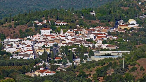
Paderne
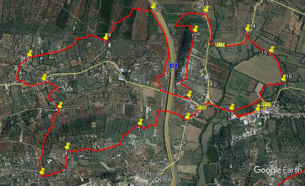
- Turn left out of the car park (1) and walk out of the town across the bridge the way you came in. At the first junction, in the strangely named suburb of Purgatorio, bear left and follow the road as it soon turns left again. Ignore the first turn to the right on a tarmac road, and take the second one, (1.15k from the start.)(2) a narrower tarmac road, just before the Purgatorio boundary sign. Go along this as it leads under the A2 motorway. Turn left after 370m on the first track after the motorway and right at the first one after that, a further 200m on. At a fork bear left after 100m more and follow this new track for 160m as it soon turns right, then quite soon after that meets a track coming in from the left. (3) Go straight ahead at this point. The track begins to climb quite steeply after soon swinging left and eventually, after turning left again to face almost due south, passing through a junction of a number of tracks (300m from 3), it reaches a T junction with a track coming up from the left.
- Turn right here and continue to climb, more gently. Pass one house on the right, and reaching level ground, pass another on the same side close to the track and soon turn sharply left, after 700m. (4) Pass another house on the right opposite a lane. Go straight ahead, descending round a wide curve to the right, passing more houses on the left, to reach a crossroads with a rather wider road after 540m. (5) Turn right and start to climb once more. Walk due north for 880m, ignoring all turns left and right, as the track crests the hill and descends again, winding a little lower down, to reach a crossroads with houses on the corners and a wooden chalet-like construction on the far right corner. (6) Go straight across and climb again, swinging round to the right to come into a group of houses and up to a junction with a tarmac lane after 400m. Turn sharp left and rise to meet a main tarmac road after a further 210m. (7)
- Just up the road from this junction is a the Café dos Matos, if refreshment is needed. Otherwise, walk past it up the hill and turn right at the first turn after 200m, on another tarmac surface, bearing right to walk through the village of Aldeia dos Matos. The tarmac eventually turns into a gravel lane, descending, after a further 370m. (8) After a long steady descent of some 600m, tending northeast, the track ends, although a narrow footpath carries on. Do NOT take this path, but turn left, walking down with a broken wall on your right, for 100m. Now turn right and walk down over rough land towards a large electricity pylon, walking past it to pick up a rough track leading down to a more obvious track coming down from the left. Turn right along this and join a wider dirt road after 140m. Follow this in the same direction for a further 100m, turning off left onto a track leading off through orange groves. (9) The track tends north-easterly over some 600m, bending to left and then right. It is a little indistinct in place where the plough has been over it, but easy enough to see where the trampled area lies. Come to a junction with a track coming in from the left, and turn right along it. At a tunnel under the motorway, (10) turn right to walk on a track roughly parallel with the motorway (you are below it with a bank on the left) for about 1.13k – the track turns away from the motorway towards the end, to avoid a water installation - to reach a tarmac road, turning left and going under the motorway to reach a turning on the left, signed to Monchina (11), 190m later.
- The road turns to the left and passes some houses on the left after 240m, it then becomes a track, running up the spine of a ridge, overlooking the motorway on one side and Paderne on the other, for a further 650m. Reaching the high point (12) with a building on the right, descend quite quickly on a winding track and come to a junction at the valley floor after 540m. Turn right to walk around the foot of the hill and along to a main tarmac road after 280m (13). Turn right and take the first left after 400m along a narrower tarmac lane. Opposite the first house you come to, on a corner after 590m, turn right off the road onto a footpath heading southeast. (14) Follow this as it becomes tree-lined on both sides, and comes to the bank of a stream. The path comes down to a crossing of the stream after 430m. (15) Cross over and follow the path on the other side along to a tarmac road after 330m. (If the stream is flowing too quickly, walk across the field on your side to reach the road and turn right to re-join at point 16.)
- Turn right at the road and turn off again right after 100m at the first bend, (16) to follow a path which first of all turns away from the stream round the edge of a field and then through trees, and then re-joins the stream line to lead all the way down to the main road into Paderne. 850m. Turn left at the road junction (17) to walk back into the town and your start-point.(440m).
- There is a short-cut towards the end which can be taken in dry conditions. This is marked in yellow on the Google photo. Some 420m after point 16, the track (and stream) turn quite sharply right. At this corner see a cap in the vegetation on the left and follow trampled grass to cross the stream-line and climb a steep flight of steps to reach the village. Walk straight ahead at the top, taking the first turn right to walk down to a junction, where you will see the car-park across the road
Orientation Normal. 37/ 8.
GPS Points.
| 1 | Paderne | 10 | 33 | 71 | 12 | 14 | 05 | |||
| 2 | Turn off road | 10 | 28 | 30 | 12 | 49 | 48 | 1.15k | ||
| 3 | Start of climb | 10 | 24 | 64 | 13 | 13 | 37 | 830m | ||
| 4 | Left on level | 10 | 13 | 39 | 13 | 48 | 45 | 700m | ||
| 5 | Right turn | 10 | 02 | 63 | 14 | 00 | 12 | 540m | ||
| 6 | Crossroads | 10 | 29 | 18 | 13 | 54 | 49 | 880m | ||
| 7 | Main road | 10 | 39 | 88 | 14 | 02 | 99 | 610m | ||
| 8 | End of tarmac | 10 | 48 | 99 | 14 | 10 | 78 | 720m | ||
| 9 | Turn right | 10 | 58 | 17 | 13 | 33 | 90 | 990m | ||
| 10 | At motorway | 11 | 12 | 61 | 13 | 10 | 91 | 810m | ||
| 11 | Monchina turn | 10 | 37 | 34 | 12 | 49 | 49 | 1.51k | ||
| 12 | End of ridge | 11 | 03 | 95 | 12 | 48 | 60 | 890m | ||
| 13 | Main road | 11 | 13 | 10 | 112 | 43 | 34 | 820m | ||
| 14 | Turn to stream | 11 | 06 | 29 | 12 | 21 | 54 | 990m | ||
| 15 | Stream crossing | 10 | 58 | 10 | 12 | 08 | 46 | 430m | ||
| 16 | Turn off road | 10 | 46 | 53 | 12 | 01 | 49 | 420m | ||
| 17 | Paderne Road | 10 | 33 | 26 | 12 | 27 | 25 | 850m | ||
| End | 440m |