Walk Forty Seven Nave do Barao – Monte Seco. 17.4 kilometres. Ascent: 530m
GPS: 37/ 13 16 61 8/ 04 27 03
This is a fairly demanding walk, taking in a wide variety of different environments and locations, from attractive river valleys to hilltops with spectacular views. There is one long steep climb and a second long but more gentle ascent. One river crossing is included, so note that after heavy or prolonged rainfall there could be a problem at that point – an escape route is described. There are four places of refreshment on the route, including the bar at the start/finish.
Getting to Nave do Barão
From the A22 motorway, (coming from the west) take the Boliqueime exit and follow direction Loulé. Go up the hill past the quarry workings and take the first left, for Parragil and Alte. At the T junction in Parragil turn left and follow this road down into a valley, across a narrow bridge and up the hill to the village of Alto Fica. Go through the traffic lights, down the hill and take the first right. This road will take you straight to Bave do Barao in the valley. The bar which is the starting point is on the right, set down a little from the road.
From Loulé and the east, take the road from Loule to Salir. When you see the water tower at Salir in the distance, look for a turn to the left, signed to Nave do Barão. Follow this into the valley and along to the village. The bar is on the left, immediately after a restaurant sign ´Adega´.
The Walk
- From the Bar in Nave do Barão, (1) walk up to the road and turn left. Walk past two sets of yellow painted metal railings on the left. At the end of the second set, after 200m, turn down the tarmac lane on the left. Turn right, right and left as it winds between houses and finally straightens. Walk a short distance to a junction, with a large blue and white painted house on the left. Walk straight across here onto a gravel covered track, and follow this as it leads straight across the floor of the valley. The track climbs a little, then levels out. Just after this point, find another gravel track on the left, and turn onto it. (620m from main road)(2) This heads first eastwards but very quickly turns south. The track is more or less straight, rising slightly. (Stay on the gravel track, ignoring any turn onto bare earth.) It then turns quite sharply right and soon curves round to the left. Ignore a track going off right as you round this bend after 940m, the climb getting steeper. A bend to the right follows, after which the track climbs further, levels out and ends after a further 460m at a junction with a wider dirt/gravel track, and an impressive view to the south. (3)
- Turn right here and follow the track as it soon descends in a winding fashion then turns sharp right and climbs again gradually.
- When the track begins to descend very slowly after 830m, look for a path leading off left (4) There is a property boundary marker, MGO 13, at the turning point. The first few metres may be ploughed over, but you can cross. Take this path as it first crosses level ground, then begins to descend. After 250m, come to an area of more open land dotted with trees. The land around the trees is ploughed to keep it clear. Follow the line made by the plough and tractor as it weaves downhill with more MGO markers on either side, bearing just west of south. At the bottom of the ploughed section, follow the plough track around the last tree onto open, unploughed land and turn left downhill, after a further 210m.
- The path swings left after another 130m (5) and continues downhill south-eastwards. Arrive at an earthwork of white stones after 230m, behind the scrub on the right. This is one of many lime-burning pits scattered across the local hillsides, the product used most often to produce cal, a whitewash traditionally used for painting houses.
- Go round the lime pit via the hairpin bend to the right, and follow the track to reach a main road after another 490m. (6) From here there is a trek of around a kilometre down the road, but you can avoid the first part of this if you wish. (if you walk down the road, pick up the description at the next italics) Turn left and cross the road diagonally to find a track leading off on the right. Turn onto this, and turn left again at the first turn off after about 50m.
- Follow this rather stony track due south as it parallels the main road. Head for a large electricity pylon and pass it on the right, descending now across what is ploughed land, with grass underfoot in the cooler weather, and without an obvious track . Eventually the land levels out as you pass through olive trees. Once on the level, bear left to find a very low wall. Walk alongside it to find a gap in the bushes. Cross the wall (only a couple of courses high) and walk diagonally left across the field to reach a narrow tarmac road. (Do not worry about trespass, you can wander more or less where you please in Portugal, as long as there are no fences.)
- Turn left here and walk back to the main road at a crossroads. Turn right. (Detour is 570m, road route is 10m less) (If you have walked down the main road, pick up the description here.) The first building on your right is a bar, (7) so if in need of refreshment, you could take advantage. (Note: this bar is closed on Saturdays) From here you have to use the main road, crossing the Ribeira do Algibre on a narrow bridge. After the bridge go round to the right, and immediately before the first building on the right, turn right down a track. (630m from the café.) (8) (Litter bins on the right, big yellow arrow on the wall left.) After 100m come to a junction. Take the second left and at a fork after another 100m bear right, going forward on level ground. Follow this valley track to another junction after 780m. Ignore the wide track crossing left to right, and take the less obvious one almost straight across, tending uphill, southwesterly, under trees. (9)
- The track trends steeply uphill first for 190m WSW, then for 130m SSW to reach a T junction with another track leading across the hill. Turn right here and follow this new track as it quickly turns uphill again towards a white house visible through trees. Follow the track as it passes to the left of the house and comes up to a junction after another 220m.
- Turn left and at another junction after less than 100m turn right uphill (10) The path ascends with some extremely thick stone walls alongside. It finally begins to level off in more open country, with houses and another trig pillar visible over to the left.
- Before reaching level ground, after around 740m (11) turn off the path in a southwesterly direction, crossing the brow of the hill on open, pathless land to discover the hamlet of Cabeças de Monte Seco hidden in vegetation over to the left after around 240m. (12) This small settlement was completely abandoned, but is now being slowly restored building by building. Walk down between the main row of houses, passing a fully restored cottage at the end on the right. Ignore turns to the left (these will take you to a main road and bus stop if you are ready to stop!) and follow the stony track on level ground northwesterly out of the hamlet. Turn quite sharply right after 240m and follow the track as it descends quite steeply, curving left, to a junction with a wider track after another 210m (13). Turn right and swing left with the track, ignoring tracks to left and right as you descend, heading northwest. After 1.24k the track turns sharply right (14) and drops to a wide dirt track running along the valley floor. Turn right along this.
- Walk for around 770m and look for an obvious turn to the left (15) leading off on level ground, down to the river. Follow this for 150m to the river crossing. There is no recognisable ford here, but you can see the opening in the reeds to head for on the opposite side. (The river is quite wide and shallow here normally, but please do not try to cross if the level is high. In this case, retrace your steps to the main valley track, turn left and walk along back to the main road at Ribeira do Algibre. From there you can either retrace the whole route back to Nave do Barao or walk up the main road, past the bar and rejoin the walk after point 18 in Alto Fica.)
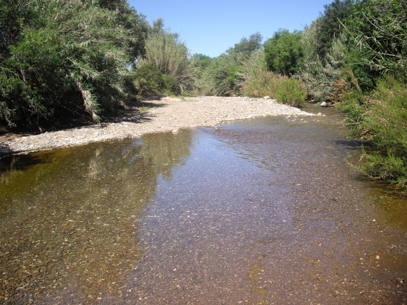
Ribeira de Algibre with water - quite a rare sight!
- Having walked through the bamboos on the far bank, walk across the meadow ahead to reach a dirt track. Depending on exactly where you hit this track, find a wide track either just left or just right, heading due north. Take this and walk up for 200m to a fork (16) Go right here, and stay left at the next fork after another 310m. The track bends sharply left after 150m, but a fainter, narrower track leads off just after the bend on the right (17) Take this track as it describes a wide arc round to the right, ascending steadily all the way, over 1.24k. Eventually see a large house ahead and left, and keep this on your left as you climb. The track swings away from the house as you approach it, becoming gravel surfaced (18) eventually emerging onto a main road again after another 310m. Turn left.
- Walk along the road, through the village of Alto Fica with its two bars, one on either side of the road. Walk on the main road until you have passed a large two-storey house with railings along the first floor balcony. (1.1k on the tarmac)) After a few metres take a track leading off on the right, (19) heading in a straight line due east, then deviating a little north of east. The obvious track becomes more faint, then see a large ruin over to the left. (300m) Stay close to the trees on the right as you pass, until faced with a line of low trees/bushes. (150m) (20) Find a narrow twisting path heading north-east through rocks and scrub. This path had become quite overgrown recently (May 2016). The path begins to descend and then drops quite steeply to an open field dotted with trees. Stay close to the left hand side of the field to reach an opening on the left onto a narrow tarmac road, close to a farmhouse. (410m)
- Turn left past the farmhouse and walk to the next turn to the right, (180m) (21) a narrow rough track leading to a small ruin. Walk towards the ruin, turning right just before reaching it, to find a low wall heading more or less easterly. Stay on the south side of the wall and follow it through three fields (you may have to weave a little to avoid bushes etc, but keep the wall in sight). Come to a lane between walls and walk up it, turning left through 90 degrees at a junction to reach a tarmac surface. (450m) Cross the road and take the narrower tarmac surface heading into the small village of Nave dos Sobreiros. (22) Turn right. Walk along this road for 770m, past the village of Nave dos Sobreiros and then downhill. Reach a point where a narrow tarmac road leads off to the right, with lines of calcadas (small flat cobbles) at the turnoff. (23) Walk down this road to find the large blue and white house that you passed on your way out of Nave do Barão at the start. Turn left at the house and make your way up to the main road in the village. Turn right by the railings to reach the bar where you began the walk.(1k from point 23).
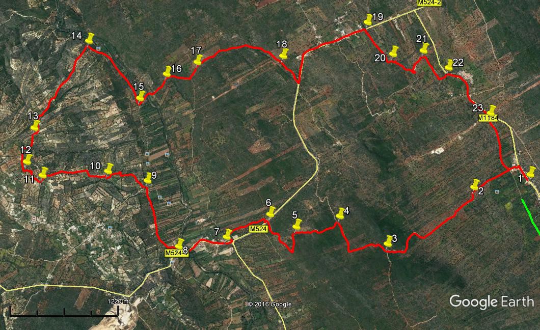
Orientation: North on right.
GPS Points: 37/ 8
| 1 | Nave do Barao | 13 | 16 | 61 | 04 | 27 | 03 | |||
| 2 | Turn off track | 12 | 55 | 95 | 04 | 32 | 75 | 820m | ||
| 3 | At wider track | 12 | 17 | 93 | 04 | 27 | 75 | 1.4k | ||
| 4 | Turn off main trck | 12 | 06 | 70 | 04 | 48 | 02 | 830m | ||
| 5 | Head of clear path | 11 | 50 | 74 | 05 | 51 | 77 | 460m | ||
| 6 | Main road | 11 | 43 | 96 | 05 | 02 | 01 | 720m | ||
| 7 | Bar Reguengos | 11 | 25 | 66 | 05 | 01 | 09 | 590m | ||
| 8 | Turn off main road | 11 | 07 | 98 | 05 | 06 | 82 | 630m | ||
| 9 | Bottom of hill | 11 | 08 | 08 | 05 | 40 | 88 | 980m | ||
| 10 | Past white house | 10 | 57 | 74 | 05 | 53 | 39 | 540m | ||
| 11 | Turn to Cabecas | 10 | 36 | 28 | 06 | 02 | 93 | 740m | ||
| 12 | At Cabecas | 10 | 33 | 53 | 06 | 11 | 54 | 240m | ||
| 13 | Descent from Cabecas | 10 | 41 | 24 | 06 | 24 | 03 | 450m | ||
| 14 | Turn to valley | 11 | 10 | 98 | 06 | 51 | 92 | 1.24k | ||
| 15 | Turn to river | 11 | 18 | 79 | 06 | 17 | 31 | 770m | ||
| 16 | Fork after river | 11 | 31 | 75 | 06 | 21 | 89 | 440m | ||
| 17 | Turn to narrow path | 11 | 43 | 98 | 06 | 20 | 50 | 440m | ||
| 18 | Nr main road | 12 | 13 | 80 | 06 | 05 | 15 | 1.13k | ||
| 19 | Turn off main road | 12 | 46 | 15 | 06 | 02 | 22 | 1.4k | ||
| 20 | Top of narrow path | 12 | 49 | 45 | 15 | 44 | 22 | 470m | ||
| 21 | Turn to ruin | 13 | 00 | 19 | 05 | 39 | 58 | 560m | ||
| 22 | Nave dos Sobreiros | 13 | 05 | 88 | 05 | 27 | 60 | 460m | ||
| 23 | Farm road | 13 | 12 | 88 | 05 | 00 | 36 | 770m | ||
| End | 1k |