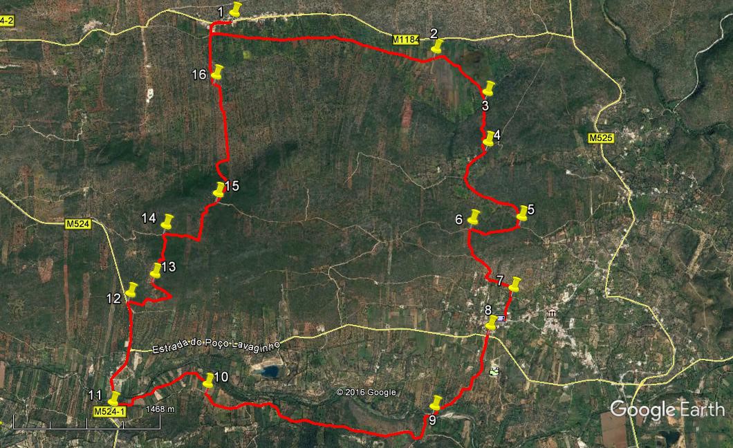
Walk Forty Eight. Nave do Barao – Ribeira de Algibre. 17.5 kilometres.
Ascent: 390 metres.
GPS: 37/ 13 60 61 8/ 04 27 03
This is a fairly easy walk from the attractive linear village of Nave do Barão, over the ridge to the equally pretty settlement of Funchais, across the Ribeira do Algibre and along to the settlement to which it gives its name. Then back over the ridge – the hardest part of the walk – to the start-point. There are no less than three bars on the route, so refreshment is not a problem. In wet conditions, or after heavy rain, the river crossing could be difficult. You can check the river levels at Tor or Ribeira do Algibre, at the bridges there. Similarly, the valley described early in the walk can flood in winter. If this is the case, bypass the flood to the right to locate the path at point 3.
Getting to Nave do Barão
From the A22 motorway, (coming from the west) take the Boliqueime exit and follow direction Loulé. Go up the hill past the quarry workings and take the first left, for Parragil and Alte. At the T junction in Parragil turn left and follow this road down into a valley, across a narrow bridge and up the hill to the village of Alto Fica. Go through the traffic lights, down the hill and take the first right. This road will take you straight to Nave do Barao in the valley. The bar which is the starting point is on the right, set down a little from the road.
From Loulé and the east, take the road from Loule to Salir. When you see the water tower at Salir in the distance, look for a turn to the left, signed to Nave do Barão. Follow this into the valley and along to the village. The bar is on the left, immediately after a restaurant sign ´Adega´.
The Walk.
- Coming out of the bar car park, (1) turn left and walk along the road, passing two sets of yellow and black metal railings on the left. At the end of the second set, (200m) swing round left and go down a tarmac lane, following this as it winds between buildings, to emerge at a junction, with a large blue and white painted house on the left. Turn left here, and follow this narrow road along the valley, passing orchards and vineyards on either side. Come to quite a sharp bend to the left, (2.4k) and take a gravel track on the right (2) which leads to a fonte or well with an information board. This is typical of hundreds of such structures in the Algarve, many of them sadly ruined.
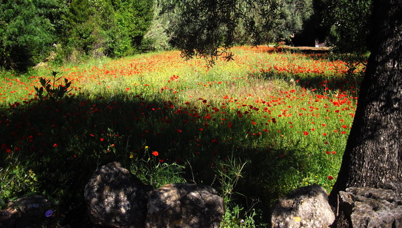
Spring Poppies, near Nave do Barao
- From here, you need to walk across the floor of the wide valley in front, going more or less southwest. Make for the base of the hill on the far side, to locate a path going uphill due south (600m from the fonte) (3). This goes straight for a time, then meanders around terraces, where some clearance has been done, passes a small building and finally emerges on a narrow metalled road (560m) (4). Turn right here and walk forward, through the small and rather dilapidated hamlet of Nave das Mealhas, winding between the houses and ruins. At a fork beyond the hamlet (350m) take the left hand option, which is a dirt-track, and follow this on level ground and then rising gently to meet a wider sandy track on a ridge. (820m) (5)
- Turn right here, walk along and at the first turn left (490m) (6) go down another dirt track south into the valley ahead. Pass a track coming in from the right, then bear more southeast, and come down to buildings as another track comes in from the right. (550m) Turn left past the house, past a third entrance from the right, then after a short straight section, round a curve to the right, facing almost due south once more. Pass a junction on the left (7) and one on the right before emerging at a T junction with a wider road. (630m) Turn right to find a bar on the right if refreshment is needed. Otherwise turn left at the next junction and walk down over a crossroads to a main road. (310m) (8) (There is another bar if you turn right at the crossroads).
- Go straight across the main road into a narrower tarmac road which runs straight along to another crossroads. Go straight across again onto a dirt track, and follow this as it winds across the valley and down to the river bank (9 )– fork left just before reaching the river.(1.06k) Cross the river at an angle to the right to locate the exit on the opposite side. Turn right along the bank and quickly left up a track leading away from the river. This soon emerges at a junction with a wider sandy track. (290m) Turn right along it and follow as it winds, rises and falls gently along the valley. After 1.7k, pass a house on the left at the top of a rise. After a further 700m, find a track on the right (10) and take this as is goes straight for a short time then bends sharply left and continues to curve left as it follows the line of the river. Eventually pass very close to the river and on to meet a main road at the end of a section of crash barrier. (1.25k from point 10) (11) This is the settlement of Ribeira de Algibre.
- Turn right along the road, and cross the narrow bridge, taking particular care with traffic here. Now walk through the settlement along the road, eventually finding a bar (closed on Saturdays) on the left as the last building, and a road junction ahead on the right, signed to Tor. (690m) Go straight up the main road past the junction. Pass one track which turns very sharply right, and take the second one, (12) more easterly in direction, which leads on level ground, arriving at a hairpin bend with a white circular structure standing in the curve. (980m) This is a lime burning pit, used to make the raw material for the lime whitewash with which houses were painted in days gone by.
- Go round the bend and climb quite steeply northwest, then turn (230m) (13) to just east of north to continue, with open land dotted with trees on the left. Reach a point where the path seems to end (130m) with trees ahead, work round the first trees to the right, then turn uphill again and follow the rough track as it winds round olive trees. Where the grove of trees ends, (190m) find a track on the right curving right and quickly resuming the uphill northerly line through the scrub. This narrow path goes up onto level ground and ends at a junction with a much wider sandy track. (14) (You may find that the last few metres have been ploughed over). (270m)
- Turn right here and follow the track 0ver a slight rise and then downhill, round a sharp left hand turn and up gain to a fork near a ridge. (830m) (15) Take the left hand path through a pass and over the ridge line, to descend quite quickly. Turn left, right and left again with the track, then go straight downhill before turning left to rise to a junction. (1.39k) (16) Turn right here to continue towards Nave do Barão ahead. At the next crossroads go across – you will recognise the blue and white house on the corner), wind through the houses back up to the road and turn right to make your way back to bar from which you started. (770m)
Orientation normal. 37/ 8
GPS Points:
| 1 | Nave do Barao | 13 | 16 | 61 | 04 | 27 | 03 | |||
| 2 | Turn to fonte | 13 | 09 | 15 | 03 | 04 | 38 | 2.6k | ||
| 3 | Bottom of track | 12 | 56 | 41 | 02 | 42 | 40 | 740m | ||
| 4 | At Mealhas road | 12 | 39 | 74 | 04 | 41 | 61 | 570m | ||
| 5 | At ridge | 12 | 16 | 66 | 02 | 26 | 62 | 1.15k | ||
| 6 | Turn to Funchais | 12 | 14 | 49 | 02 | 45 | 88 | 500m | ||
| 7 | In Funchais | 11 | 53 | 76 | 02 | 26 | 94 | 940m | ||
| 8 | At main road | 11 | 40 | 88 | 02 | 35 | 09 | 560m | ||
| 9 | River crossing | 11 | 13 | 75 | 02 | 55 | 57 | 1.1k | ||
| 10 | Turn off main track | 11 | 16 | 14 | 04 | 28 | 33 | 2.7k | ||
| 11 | At Ribeira de Algibre | 11 | 08 | 15 | 05 | 06 | 60 | 1.25k | ||
| 12 | Turn off main road | 11 | 43 | 94 | 05 | 01 | 98 | 1.16k | ||
| 13 | Turn in track | 11 | 50 | 82 | 04 | 51 | 80 | 700m | ||
| 14 | Junction with main track | 12 | 06 | 70 | 04 | 48 | 01 | 540m | ||
| 15 | Fork near ridge | 12 | 17 | 91 | 04 | 27 | 72 | 830m | ||
| 16 | Track junction | 12 | 55 | 95 | 04 | 32 | 75 | 1.39k | ||
| End | 770m |