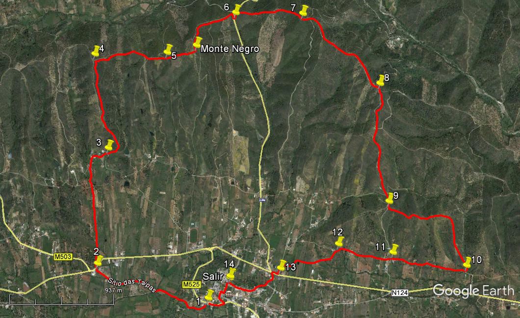
Walk Forty Six. Monte Negro 13 kilometres. 530m of ascent.
GPS: 37/ 14` 24.44 8/ 02`52.82
This shortish but quite taxing walk takes you from the outskirts of the small town of Salir to the highest point of the ridge north of the town, returning in the valley from the east. There are some steep ascents and descents, but some spectacular 360` views as a reward.
Getting to Salir.
From the west, pick up the N124 from Silves, Messines or Benafim and turn right at the roundabout below the town. Drive up the winding road and find the Café Opcao on the left soon after reaching level ground. From the south, leave the A22 at the Loule Centro exit, and follow signs to Boliqueime and Sao Bras. There are three roundabouts to negotiate – one by the fire station (Bombeiros), one at the turning to Boliqueime and the third one where you turn left for Salir. Follow the road over a long hill and down to traffic lights. Go straight across and over a second long hill to come down to Salir, noticeable for the tall water tower. Cross the bridge in the valley and go up to the town. Pass a petrol station on the left, and the café is on the right soon afterwards.
The Walk.
- With your back to the Café Opcao, (1) cross the road diagonally to the right, towards a display board illustrating a local walk. Right of this, take a narrow paved track leading away from the road, curving round to the right. Take the second turn on the right onto a dirt track, (after 200m) and at the next junction stay left. Come to a stream or dry bed after a further 370m and cross, (concrete stepping stones if stream is flowing) bearing right almost immediately afterwards. Arrive at a main road in the small settlement of Taipa, (660m from the stream) (2) and cross diagonally right to take a track on the left immediately past the Taipa boundary sign.
- Now follow this almost straight track due north, at first on level ground and then rising gently. Arrive at a junction with a narrow tarmac road after 770m and go straight across towards some houses on the hill in front. Ignore a turn to the left and climb the steep hill to the houses. Now follow the road through the hamlet of Pe da Serra as it swings to the right – ignore a turn to the left uphill. Opposite the last house, set back on the left, as the road swings sharply right, take a dirt track facing you. (3) At a fork after 100m, swing left steeply uphill.
- Follow this track as it climbs just west of north, sometimes steeply, sometimes less so, ignoring only one obvious fork on the left. Arrive at a summit at a T junction in the track after 900m (4) and turn right. Note the excellent views that have now opened up in all directions. From here, stick to the ridge at all times, ignoring any track leading down on either side. Descend from this first summit into a hollow, and climb again to a slightly lower height. Then continue up the ridge to the base of the imposing hill in front. 700m (5) This is Monte Negro, one of two heights in this area with that name. Ignore the track descending on the left and continue up the slops, tending eastwards as before.
- After breathing deeply, ascend the very steep track leading to the summit of Monte Negro. 280m. The reward at the summit is the best view so far, and a large trig pillar with iron rungs that can be climbed to give an even better all-round vista. To the south see Salir with its prominent water tower at the eastern end.
- Past the trig pillar turn left to begin the long steep descent, which ends at a tarmac road connecting the Salir valley with the one further north. (690m)(6) At the point where your track meets the road, go straight across to another track leading uphill towards the third and final summit of the day. It turns left immediately and then very soon right, (due east) to ascend quite steeply. Ignore forks to left and right at 250m, and climb to the top.
- At the summit, (730m from 6) (7) swing left, and after a short descent come to a cross tracks and go straight on east. Ignore another track on the left and follow your track as it curves to run almost due south, now descending very gently. Again, follow the ridge line and ignore a fork to the right after 320m, then descend south-easterly more quickly for around 300m, passing a turn to the left. Level out, and begin to rise again very gently, passing another turn to the left. Now resume the descent more gently and pass a turn to the right after a further 310m.
- After a further 140m, passing a turn to the left on the way, come to a fork and take the right hand, due south. (8) Follow the track down for around 390m. Arrive at a junction and turn sharp left and then almost immediately right to continue to descend. As you descend, see a mobile phone mast ahead and right, and soon Salir as well, in the distance. Coming down to a cross-tracks after 670m, with a single house ahead and right, go straight over and climb to the next ridge, a further 110m (9)
- Turn left at the ridge up a rather less obvious track eastwards, climbing steadily. Once again, follow the ridge line here as it winds along, ignoring anything leading downhill on either side. The track swings quite widely to the right after around 630m and begins to descend south towards the valley. This point is very clear, as there is no other way to go. Follow all the way to the bottom (560m), joining a wider dirt track shortly before meeting a concrete road at a T junction. (10) Turn right.
- Walk along the concrete, passing one or two houses. Pass a village boundary sign ´Picotas´ and soon come to a junction, noting a house with a car port on the left after 730m. Pass the house and take the narrow opening opposite, (11) up a short rise to pass between houses. Ignore the turn to the left past the houses, and follow the straight line as the lane becomes a footpath behind a low building and then emerges onto open land, rising slightly. After 310m, this track ends at a concrete road once more. Turn right along it and follow as it winds between houses. A little further on, as the road rises quite steeply towards another set of houses, turn left halfway up the hill onto a dirt track. (240m)(12) (Boundary stone HT1 opposite the turn).
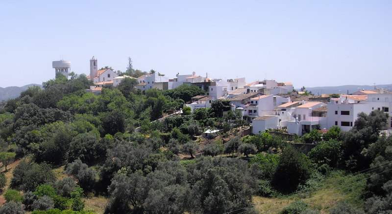
The old town of Salir, from the castle.
- Now walk this farm track as it winds across a valley floor. Cross straight over a track going to an industrial shed halfway along. The track rises after 630m to meet a narrow tarmac lane, with Salir Water Tower and church up on the left. Turn left and walk to the main road ahead. (13) Turn right here, walk a short distance and then cross the road to take a tarmac lane leading uphill on the left, with a Salir boundary sign a few metres up, and signs to Loule, Salir and GNR. After a few metres turn right up a cobbled lane which rises steeply to meet another tarmac lane.
- Turn right up this to reach a junction, with the church up to the left and a narrow street descending to the right. Take this street and walk down until it levels out. Now look for the Rua Jose Silva Elias on the left (610m from 13) (14) and turn along it to reach the main street of Salir, with a restaurant and bar facing you. Turn right and then by the Farmacia (Chemist) shop cross the road and take the lane opposite, go forward on this and take the second on the left, down a cobbled lane to reach another main road. Turn right here to walk the short distance to the bar from which you started. (400m)
Orientation Normal. 37/8
GPS Points
| 1 | Cafe Opcao | 14 | 24 | 57 | 02 | 54 | 14 | |||
| 2 | Main road crossing | 14 | 35 | 72 | 03 | 35 | 73 | 1.19k | ||
| 3 | Pe da Serra | 15 | 10 | 39 | 03 | 31 | 11 | 1.23k | ||
| 4 | At ridge | 15 | 38 | 49 | 03 | 34 | 16 | 1k | ||
| 5 | Foot of Monte Negro | 15 | 38 | 22 | 03 | 06 | 81 | 700m | ||
| 6 | Road crossing | 15 | 50 | 76 | 02 | 40 | 40 | 960m | ||
| 7 | Junction on ridge | 15 | 48 | 06 | 02 | 14 | 92 | 730m | ||
| 8 | Fork in track | 15 | 26 | 21 | 01 | 47 | 02 | 1.1k | ||
| 9 | Ridge after lone house | 14 | 51 | 09 | 01 | 45 | 30 | 1.18k | ||
| 10 | At concrete road | 14 | 31 | 06 | 01 | 16 | 49 | 1.19k | ||
| 11 | Arneiro | 14 | 35 | 75 | 01 | 44 | 15 | 750m | ||
| 12 | Turn off concrete | 14 | 38 | 59 | 02 | 04 | 64 | 550m | ||
| 13 | At main road | 14 | 32 | 40 | 02 | 26 | 82 | 730m | ||
| 14 | Junction in Salir | 14 | 30 | 75 | 02 | 45 | 72 | 610m | ||
| End | 400m |