Walk Forty One. Malhao Circular. 14.5 kilometres Ascent: 700 metres.
GPS: 37/ 18`05.17 8/ 06` 04.17. (Café Miramar)
This walk starts at high level on the outskirts of the small settlement of Malhao, descending into a deep valley, over a ridge and down to the village of Zambujal, before making the long climb back to the start. Views and countryside are spectacular from start to finish. There are no refreshments on the route, other than at the start/finish.
Getting to Malhao.
From the A22 motorway or the N125, take the IC1 road north to Sao Bartolomeu de Messines. Turn east along the N124, signed to Alte and Salir. Stay on the road through Alte. Benafim is the next main settlement along the road. At the eastern end of the village, turn left at the roundabout and follow all signs to the small settlement of Sobradinho, just over 6k away. At Sobradinho, turn right towards Cortinhola on the M542. Drive through this scattered settlement and stay left at a main junction, now signed to Malhao (brown sign). Follow signs to Malhao, passing Pe de Coelho and climbing a steep, winding road. As the road levels out at the top, see the Café Miramar ahead on the right hand side of the road. Park here.
The Walk.
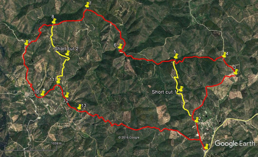
- From the café, (1) walk along the road to the left of it (on level ground). See a circular building ahead and leave the road to walk up to and past it. Walk downhill towards houses on the left. Immediately after the last small building veer left (2) and very shortly join a track coming in from the right. Ignore a faint track on the left and come to a fork, taking the fainter track to the right after 200m. Stay on this track, walking northwest but gradually turning more northerly and finally due north, with another track coming in from the right. After 670m come to a fork and take the right hand track, which leads down to a junction with a much wider dirt road after a further 720m (3). Turn left.
- Take the first turn left off this road after 430m (4) on a track going quite steeply downhill, turning left very soon. Descend for 1.25k to meet a track at a T junction going uphill and continue down the valley. (5). Continue for around 1.12k, always descending, to reach the valley floor. As the track levels out, pass tracks on right and left leading uphill, and continue ahead. Around 180m from the left-hand track, approach a sharpish curve to the left, and just as you go into this curve, find a narrow track on the right going uphill and turning right very quickly. (6) Follow this track as it then curves left after 100m and climbs steeply, curving round to the left again quite soon. Ignore all turns going downhill on this section.
- After a long climb, (around 1.33k from 6) the gradient eases, and a T junction is reached. (7) Turn left , walk 190m almost due south to a fork and bear right, now on more or less level ground. The track then begins to descend and at the next junction bear right again (8) (690m) and descend on this clear track, ignoring a multi-way junction on the way down, to reach a much wider road after 950m. (9 ) Turn left. Descend to the valley floor and pass by the bridge over a stream, leading to the hamlet of Zambujal after 1.17k., now on a tarmac surface. Bear left at the next fork after a further 160m (10) and climb to the small settlement of Corte Bucho. Ignore a turn to the right at the entrance to the hamlet, and swing sharply round to the right past the last houses after 480m (11) to descend to the river south-eastwards and then almost due south on a much smaller track. (370m)
- Cross the river (12) (If the water level is too high, turn right and walk a short distance back to the tarmac road to find a dry crossing. Then turn left on the far bank, back to the original crossing point.) From the crossing, go up on a track to where two tracks meet and find a faint, narrow track leading up the hill in front, heading south-east. Climb the hill using faint footpaths and come to a line of ruins after around 230m. Walk along in front of the ruins for 100m to reach a bend where a tarmac road gives way to a dirt track. (13) Take the dirt track left as it goes uphill. This track leads in a winding fashion back up to the road on which the walk began (2.96k). Simply follow the main track and do not take any left or right turns. When you reach the tarmac at the end of the long climb, turn right to walk back to Café Miramar. (240m)
NOTE:
On the photo of the route, you will see two short-cuts marked in yellow. If you wish to use these, you will need to make careful use of Google Earth to locate these for yourself, and take the details out on your walk.

Looking back from the foot of the long climb home.
Orientation normal. 37/8
GPS Points.
| 1 | Cafe Miramar | 18 | 05 | 17 | 06 | 04 | 17 | |||
| 2 | Left after houses | 18 | 22 | 73 | 06 | 10 | 80 | 600m | ||
| 3 | Main track | 18 | 52 | 25 | 05 | 35 | 94 | 1.58k | ||
| 4 | Turn off wide track | 19 | 03 | 70 | 05 | 41 | 34 | 430m | ||
| 5 | Track junction | 19 | 04 | 88 | 06 | 23 | 19 | 1.25k | ||
| 6 | Turn uphill | 19 | 13 | 71 | 07 | 09 | 54 | 1.36k | ||
| 7 | Top of climb | 19 | 41 | 22 | 07 | 34 | 51 | 1.33k | ||
| 8 | On descent | 19 | 32 | 12 | 08 | 03 | 16 | 850m | ||
| 9 | Track junction | 19 | 19 | 22 | 08 | 28 | 33 | 950m | ||
| 10 | Turn to Corte Bucho | 18 | 44 | 52 | 08 | 18 | 20 | 1.33k | ||
| 11 | At Corte Bucho | 18 | 52 | 51 | 08 | 03 | 75 | 480m | ||
| 12 | River crossing | 18 | 42 | 37 | 07 | 57 | 44 | 370m | ||
| 13 | After ruins | 18 | 34 | 06 | 07 | 46 | 59 | 430m | ||
| End | 3.2k |