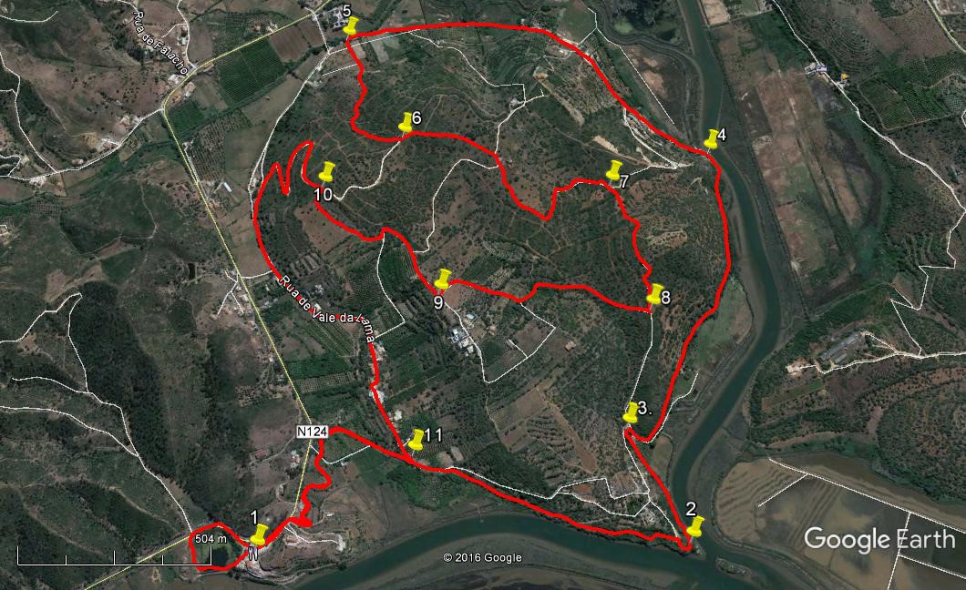
Walk Seventy Six. Ilha de Rosario. 10k Ascent 230m
GPS: 37/ 11 14 02 8/ 29 15 63
The shortest walk in this series, this is ideal for a late spring outing, when the temperatures are making long days difficult. It takes a tour around a large promontory that lies between the Arade and Oudelouca Rivers. It goes to the point of confluence of the rivers along one of the irrigation canals or levadas that are a feature of the local landscape, then follows the Arade upstream for a while before heading over the low hills behind, with some excellent views over the waterways, before returning to the start and looking briefly at a small lagoon with a variety of bird life. Refreshments at the start, and possibly halfway round. I am indebted to John Hope for taking up and leading this walk from earlier versions.
Getting to the Start.
The walk starts from the Mira Rio restaurant and bar, on the main N124 road between Silves and Portimao. From Silves follow the main road west along the riverside and drive for 5.25k to a point where the road bends sharply to the right. The restaurant is on the left at the crown of the bend. Take great care when turning into the car park. From Portimao and the west, take the N124 from the town or the A22 motorway, signed to Silves and Monchique. Just beyond Porto de Lagos turn right at a roundabout towards Silves and follow the road for 6.75k to find the restaurant on the right.
The Walk.
- From the restaurant (1) turn right to walk for a short distance along the main road. Find two dirt tracks leading off right very close together. Take the second of these, and almost immediately fork left to drop down towards a narrow water channel. Turn sharp left to walk along beside the channel as it winds around below the road. This is an irrigation channel or levada. Follow it for 1.34k as it crosses roads and runs close to the river. Come to a point where the channel turns very sharply left, and walk a little further south-west to emerge on a rocky headland at the confluence of the two rivers. (2) 1.4k from the start).
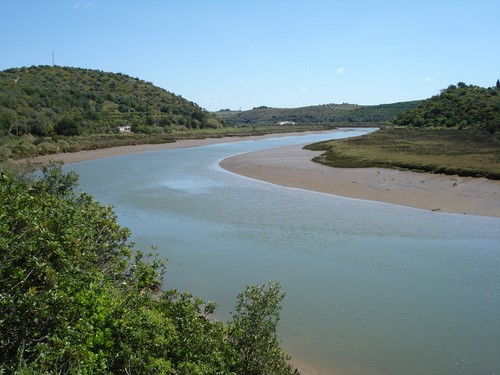
Near the confluence. (Photo credit Geoff Lee)
- From here continue along the levada as it hugs the riverside, then turns away for a time and rounds a cottage in a tight right hand curve (3) 340m. It then runs south-east and re-joins the riverside after a time, finally passing close to a building on the riverside some 980m from the cottage, with a boat landing and perhaps one or two craft moored alongside. (4) This is the Clube Nautico where, if you are lucky, you might find refreshment, though it is often closed at lunchtimes. Leave the levada there and either stop for a drink or carry on on the track that leads uphill away from the building.
- From here walk for 1.27k along this track as it turns away from the river. After around 900m pass very close to a tributary of the Arade on the right. Now take the second track on the left after this point, where the tributary (narrower now) runs parallel to the road once more. (5). Head towards a house about 150m away. At the point where the track to the house turns left towards it, go straight ahead on a faint path that climbs the hill in front. Head first south-west and soon north-west, still climbing, to meet a rather clearer track coming in from the right after around 200m. Turn left along this new track, climb further and arrive at a wide dirt road after a further 210m, now facing due south. (6)
- Turn left and follow the road along more or less level ground for 280m. Coming to another junction turn right, and walk past an old circular threshing floor, with a house beyond it. Past the threshing floor take the left-hand (narrower) track and descend slowly over the next 800m to reach a fork in the path, at which point take the right-hand option (7). Walk more or less south-west, first slightly uphill, then similarly down, to reach a junction with a track heading north after 430m. (8) Follow this track as it becomes quite faint, heading uphill due north for about 400m. It meets another track crossing from the right, with a ruined building visible about 100m away on the right. Turn left with the track and then right again after another 100m, to face due north once more, on a better path.
- The path, now on level ground, eventually makes a sharp turn to the left and ends at a junction with a wider road after a further 260m. (9). Turn right here and walk for a further 290m to a left-hand hairpin bend. Go round the bend and take a path on the right very soon that leads north around the hill to the right, turning right again and joining a wider track after a further 280m. (10) Turn left and wind down into the valley. Facing a building near the bottom veer left and arrive at the valley floor after 660m. Continue ahead (south-west), entering a tarmac road with the N124 visible over on the right. The road veers right and then left before entering the small settlement of Val da Lama.
- Walk straight through the village on this road. The road does a dog-leg right and left between houses, and then descends, with houses now on the left. Arrive at a hairpin to the right (11. 1.57k from 10) and go round to turn on to the side of the levada once more. Go ahead along it to retrace your steps to your exit onto the N124 near the restaurant. (560m from 11). Just beyond the restaurant lies a small lagoon where numbers of birds congregate. You can do a circuit of this by dropping down from the far side of the restaurant onto a path below the levada, which is raised on an aqueduct here. Simply walk round the lagoon and return to the restaurant on the main road. (410m)
GPS 37/ 8. Orientation normal
GPS Points
| 1 | Mira Rio | 11 | 14 | 02 | 29 | 15 | 63 | |||
| 2 | River confluence | 10 | 36 | 87 | 29 | 04 | 98 |
1.58k |
||
| 3 | Right hand bend | 10 | 44 | 06 | 28 | 54 | 29 | 340m | ||
| 4 | Clube Nautico | 10 | 40 | 65 | 28 | 19 | 48 | 990m | ||
| 5 | Turn off left | 11 | 17 | 96 | 28 | 13 | 50 | 1.27k | ||
| 6 | At top track | 11 | 09 | 58 | 28 | 26 | 33 | 500m | ||
| 7 | Track fork | 10 | 49 | 54 | 28 | 26 | 96 | 790m | ||
| 8 | Turn north | 10 | 43 | 83 | 28 | 40 | 70 | 430m | ||
| 9 | Main track | 11 | 02 | 93 | 28 | 44 | 11 | 650m | ||
| 10 | Main track | 11 | 15 | 79 | 28 | 34 | 21 | 570m | ||
| 11 | Hairpin right | 11 | 02 | 18 | 29 | 02 | 21 | 1.59k | ||
| End | 750m | |||||||||
| Lagoon circuit | 410m |