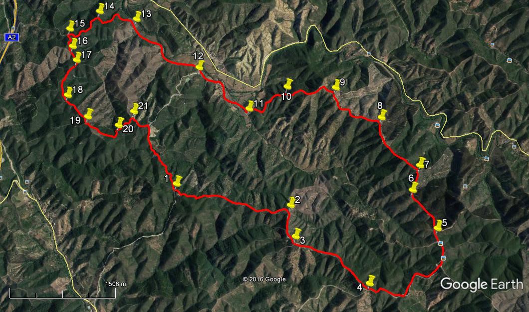
Walk Forty. Gralha Circular. 17.6 kilometres. 850 metres of ascent
GPS: 37/ 20 59 94 8/13´37.41
This is a walk which starts at high level, descends to a valley and climbs again to the finish. All the tracks are clear. There is a long steep descent and an equally steep climb. One isolated village is passed; otherwise the whole walk is through empty land with low scrub and eucalyptus trees as the main vegetation on the high ground. Parts of the valley floor are cultivated, and there is a magnificent orange tree in the centre of the village. There is one water-crossing to contend with as you approach the village, which could be awkward after heavy rain. If walking with dogs, there is water in the valley but not elsewhere, and there are chickens running loose in the village. Views are spectacular throughout. Refreshments only at Foz de Ribeiro.
Getting to Gralha.
Gralha is a one-house settlement on a hilltop about five kilometres from the nearest village at Foz do Ribeiro. Those five kilometres are on a dirt road, very broad but a little rutted in places, especially on the climb to Gralha itself. An ordinary car will make the trip easily enough, but if you have a 4x4 then use it!
Directions: The nearest town is São Bartolomeu de Messines, on the EN 124. Reach it either on the 124 from Silves or on the IC1 going north from Albufeira. In either case follow the 124 signed for Alte, Salir and the A2 motorway, until reaching a roundabout signed Alte/Salir right, A2 ahead and Messines left. Take the left exit for Messines, and follow this road along a straight stretch. Immediately after the first bend turn right on the M 510 signed to Campilhos and Foz do Ribeiro. Follow this minor road for just over 8k as it winds through Campilhos and then open country, all the way to Foz do Ribeiro. Drive through the village, reaching the ´Casa do Pasto Odilia e Florival´ on the right, on the northern edge. Coffee is available here, and lunch too if you return in time.
From the café/restaurant, continue along the road, taking the second left over a small bridge. From here the road becomes a wide dirt-track. After around 1800 metres, reach the hamlet of Val Fontes de Baixo, and turn right uphill. The track becomes a little more uneven from here. Drive for another 2.5 k, reaching a point on a bend, with a house half-hidden in trees up to the right and where the road begins to descend. Park on the side of the road.
The Walk.
- With your back to the earth bank on the bend, (1) see two main dirt-tracks ahead across the road. Take the left-hand track, which runs almost level and then slightly downhill, passing below a house up to the right. Follow this track as it first descends and then begins to rise, bearing almost due east. At one point there is a sharp little rise that you can walk around to the left. Come to a point where the track swings quite sharply right, with a track leading off downhill to the left. (1.79k) (2) Stay on the main track round this bend, now heading almost due south, climbing steadily. After 500m, going through quite sharp left and right hand bends reach a point where the track divides. (3) Turn left here to go down a short but steep slope and continue along the track, heading west-south-west. The direction becomes more south-west, climbs again, and after 1.33k reaches a junction with a much wider dirt road. (4) This is a public road, so you can expect a very occasional vehicle. (It is also used quite often for a section of the Rally of Portugal). Turn left.
- Follow this very wide dirt road as it winds downhill to a ´saddle´ between two valleys (890m) (note the excellent views on both sides) and then begins to climb again quite steeply, swinging round to due north. Pass three obvious tracks leading off to the right, and one to the left. Shortly after this left-hand track, the road you are on turns sharply right at a crest and begins to descend. Just before this curve find twin tracks leading off to the left, (2k from 4) (5) and take the right-hand of the two. This takes you uphill to the corner of a eucalyptus plantation on the right. Follow the track along, with the trees to your right. (More planting is happening all the time, so you may find younger eucalyptus growing on your left as well.).
- After 720m, travelling NNW, the track swings round to just east of north (6) and drops into a depression, rising again quickly. At the top of the rise, after 390m, turn left, NW, (7) and follow the track as it winds along on a ridge line, sometimes with open land on either side, sometimes with more trees to the right. Continue in this way for 980m as the direction turns more to the west, descending a little after a short level section. (8) The land becomes more open, but with further evidence of planting, this could change. Go through another depression and then climb again. At the end of this stretch, this track curves round a wide right-hand bend and heads off north-easterly, descending. (960m) (9) Before this bend find a much less obvious track leading off to the left on level ground and slightly overgrown.
- After heading roughly NW, swing sharply left to face south-west and begin to descend. This next long stage is a steady descent to the valley floor. Ignore all tracks leading off to the left and follow this rocky winding path between hedges of gum cistus, (870m)(10) finally coming onto level ground at a T-junction with a narrow dirt road. (810m)(11)Turn right.
- Follow the dirt road crossing a small stream immediately before entering the hamlet of Ribeira de Oudelouca. Find the very large orange tree facing you after 570m, covered with fruit in season, and pass to the right of it. Round the bend, take the left-hand track at a fork and walk along a walled lane towards and past houses. After 200m or so climb a short, sharp rise to join a very wide dirt road with a high bank facing you, and turn right downhill. (12) (If at this point you have had enough, turning left here will take you straight back to your car at the top of the hill, after about 2.25k.)
- After rounding the bend as you descend, ignore a turn to the right after 140m and follow the track as it meanders along the valley floor, passing the occasional house, with the bamboos along the water-course always visible on the right. The track passes through a wooded section, rising slightly, then descends again to pass a barn-like structure on the right – ignore the right turn here. The path then rises towards a house on the left. (1.4kfrom 12.)(13) This is a very pleasant place for a lunch-stop, with a lovely view back along the valley and up to the hills you have just walked.
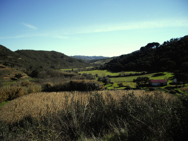
Lunchtime view.
- Ignoring the track to the left past the house, continue ahead, avoiding a turn to the right across the stream after 140m before starting to climb quite steeply, swinging round a sharp left-hand bend SW. Ignore a wide turn to the left after 280m and climb, swinging northwest to a T-junction after a further 310m. (14) Turn left, climbing all the time, heading southwest. Ignoring lesser paths to left and right, turn almost due west and reaching another main junction, turn left. (580m)(15)
- Now heading south southeast, climbing then beginning to descend, ignore a turn right after 100m . Arrive at a fork after a further 220m and stay left (16). Turning slightly more southeast, on more or less level ground, after 140m stay right at a fork and right again at a second fork very soon afterwards, crossing straight over at the next junction (17)(260m from 16), the track now having swung round to southwest. Walk forward rising gently, for 210m, swinging from southeast to due south. Find a track on the left leading off at a narrow angle and follow it for 410m, rising but leaving slightly higher ground to the right.
- Rejoin the track you left 410 metres ago (18), and go forward, dropping slightly at first, then climbing again quite steeply, heading southeast. Pass a track on the right at a summit (19)after 460m, and turn more easterly and ignoring a track on the right leading uphill, as your path begins to descend. Descending steadily, swing round to the northeast and merge with a track coming in from the right after 580m. (20) Stay on this north-easterly course over undulating ground for a further 330m, arriving at a junction with two tracks leading off northwards. (21). Swing round to the southeast and climb very gently to join a wide gravel road. Turn right at the road to walk back about a kilometre to your starting point.
Orientation Normal. 37/ 8.
GPS Points.
| 1 | Gralha | 20 | 59 | 94 | 13 | 37 | 41 | |||
| 2 | Right turn | 20 | 54 | 94 | 12 | 29 | 48 | 1.79k | ||
| 3 | Top of slope | 20 | 40 | 81 | 12 | 25 | 01 | 500m | ||
| 4 | Wide track | 20 | 22 | 50 | 11 | 39 | 93 | 1.33k | ||
| 5 | Up to euclayptus | 20 | 50 | 78 | 11 | 02 | 91 | 2k | ||
| 6 | bend in track | 21 | 07 | 19 | 11 | 18 | 93 | 720m | ||
| 7 | Turn NW | 21 | 18 | 95 | 11 | 15 | 74 | 390m | ||
| 8 | Turn W | 21 | 39 | 81 | 11 | 40 | 47 | 980m | ||
| 9 | Turn on fainter track | 21 | 51 | 96 | 12 | 08 | 99 | 960m | ||
| 10 | Halfway down | 21 | 50 | 93 | 12 | 37 | 50 | 870m | ||
| 11 | Valley floor | 21 | 39 | 02 | 12 | 59 | 33 | 810m | ||
| 12 | Top of rise | 21 | 56 | 80 | 13 | 32 | 05 | 1.1k | ||
| 13 | Lunch spot by house | 22 | 17 | 88 | 14 | 13 | 43 | 1.4k | ||
| 14 | Junction 1 | 22 | 19 | 03 | 14 | 34 | 97 | 730m | ||
| 15 | Junction 2 | 22 | 08 | 81 | 14 | 50 | 91 | 580m | ||
| 16 | Junction 3 | 22 | 00 | 52 | 14 | 47 | 98 | 320m | ||
| 17 | Junction 4 | 21 | 53 | 99 | 14 | 44 | 80 | 260m | ||
| 18 | Junction 5 | 21 | 36 | 80 | 14 | 46 | 95 | 620m | ||
| 19 | Junction 6 | 21 | 27 | 48 | 14 | 33 | 47 | 460m | ||
| 20 | Junction 7 | 21 | 24 | 82 | 14 | 15 | 19 | 580m | ||
| 21 | Junction 8 | 21 | 32 | 08 | 14 | 07 | 11 | 330m | ||
| End | 1.1k |