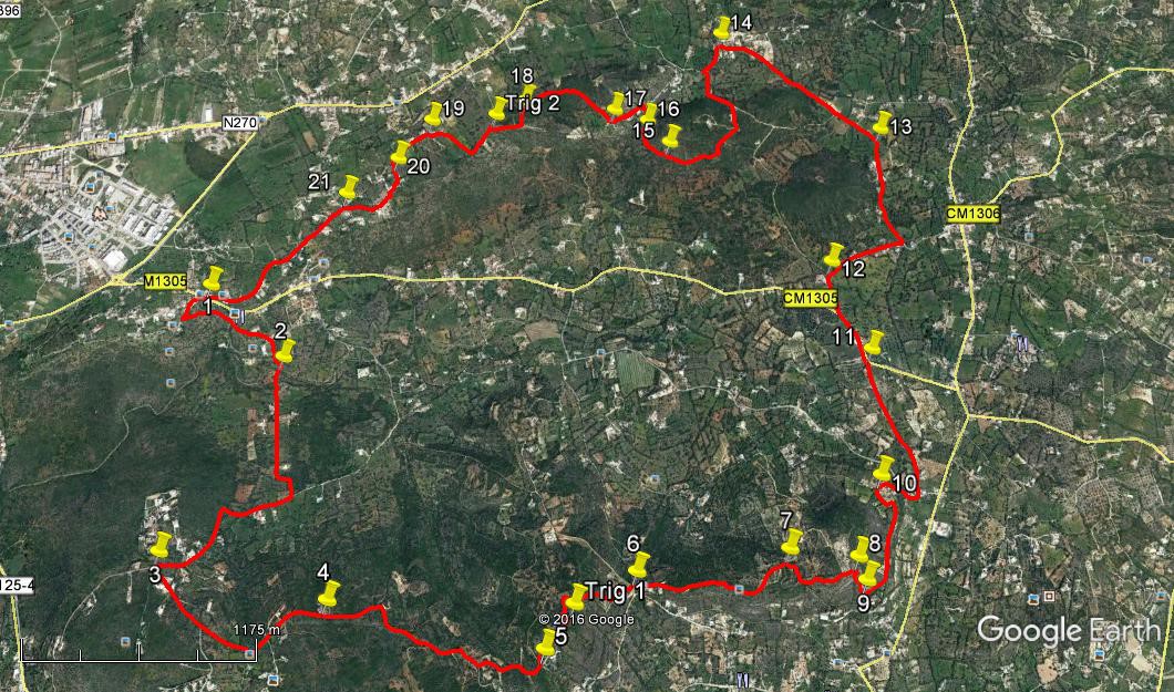
Walk Thirty Nine. Goldra Circular. 15.6 kilometres. Ascent: 400 metres.
GPS: 37/ 07 44 45 7/ 59 56 49
This walk circles the sprawling area of small villages and open country to the south-west of the large town of Loulé, generally known as Goldra. There are two settlements – upper and lower Goldra (in Portuguese, de cima and de baixo), but the walk takes in a good deal of the surrounding area as well. It covers a wide variety of countryside, with some excellent sea views and pleasant country lanes.
Getting to Goldra.
The easiest way is to take the A22 motorway to the Faro Airport/ Loulé Sul (south) exit, and turn left for Loulé. Follow this road up a long hill, over the top and down to a roundabout in the suburb of Goncina. Take the first exit and drive to the next roundabout, turning right here. At the next roundabout, turn right, signed to Goldra. Climb the hill for around 500m, and as the road begins to descend after a bend to the right, see the Café Tres Cantos on the right, opposite a junction. Parking is not easy here, though there is some space just before and a little way down from the café. Leaving your car outside the café all day might be frowned on!
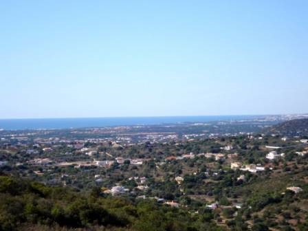
Looking out to sea from near the first trig pillar.
The Walk.
- With your back to the café, (1) turn left and walk up the hill, taking the first turn on the left and then forking left shortly after that. At the next fork go left again, and almost immediately find a narrow path going back to the left at a sharp angle to the road. (200m) Follow this path as it traverses the hillside and then drops down to a wider track leading down to the valley floor. Cross over the road at the bottom and continue almost due south to swing round and cross a stream on a bridge. (680m) (2)
- Now walk straight across the valley floor, kink left, then right, and arrive at a junction. (700m) Turn right and walk up this metalled road, rounding a sharp left hand turn. Reaching level ground, look for a turning on the left going uphill, with post boxes and lots of direction signs to villas on the near corner. (830m) (3) Turn up here and take the second turning on the left at a fork. (390m) Continue uphill and take the first turning on the left, onto a stony dirt road.(280m) Go along and up once more, passing the Goldra Dog Sanctuary on the left. (440m)(4)
- The road bends to the right and begins to climb again, heading southeast. Follow it up, avoiding all turns on right and left, until reaching the end of the driveable road at the gates of a large villa, the road turning northeast in the last few metres (1.24k) (5) Pass to the left of this, and take the right hand track up hill to reach a building on one side and a trig pillar on the other. (270m) Go through the vegetation to the trig to get your first great view of the sea and the coastal plain.
- Turn left and then right after the building, onto a wide track, and at the next corner, turn right by a pylon to follow a narrow footpath over and downhill, behind a large villa, to reach a track junction at the bottom. (470m) (6) Go left and right to climb again past another large villa on the right, onto the Caminho do Moinho das Estrelas (Windmill Lane). Walk east up to and past two windmills, one restored – but not as a windmill, and the other ruined. (610m) From the ruin, turn down to the left, walking 140m northeast, then half-right closer to east for another 100m to reach a track junction turning right uphill again (7). Now wind your way uphill due south on to level ground and turn east, walking until the track turns sharp left at an open space, with no apparent way straight ahead (410m) (8).
- To the left are quarry workings – steer clear. Go past the turning, staying on the right and go to the edge of the steep hill on the right. Find and work your way carefully down the rocky terraces, aiming to travel roughly south south east. Below the rocky area find a narrow stony path leading downhill, and aim to come down just to the right of the house you can see below you. (150m) (9) Just above the house, find a narrow track cutting across your line, and turn left along it, roughly northeast. Pass through a narrow gap at the end of the first open field, over a low wall, and cross another area of open land to reach the end of a wide dirt road. (100m)
- Walk along this as it skirts the lower slopes of the hill you have just come down. Arrive at a left- hand bend, (420m) with a group of houses ahead and right. Walk to the next junction (10) and turn right to go downhill and round the houses, now on a tarmac road. At the junction below the houses (240m from 10) go diagonally across a main road into a narrow lane with a building on the right. Walk along this lane for 700m to meet another tarmac road and bear left along it (11). Pass a building with a green roof and fork right at the next junction after 310m, turning right again at the first corner a further 200m along (12).
- Walking gently uphill, come to a sharp right hand bend after 430m and turn left into a narrow lane. Walk due north along this, avoiding a turn to the left after 150m. 230m further on come to a gateway. Take the narrow footpath to the right of this, and emerge at a junction with another lane after a further 230m (13). Turn left here and now head north-west in a straight line, for 760m, heading towards a development of large new houses. The road bends to the left, climbing, in front of the new houses to reach a 90 degree turn to the left, now with houses on both sides (14) after which it soon meets a road at a T junction, on a descent into a valley.
- Turn quite sharp left here, and at the first fork after 280m, (the road has become a track) bear right, past a large house, and staying on the main track walk round a wide curve to the right until the wide path comes to an end after some 630m, with a house and buildings on the right. (15) Go straight ahead onto a much narrower path between trees, which after around 300m comes out onto more open land by a ruined property with a dirt track running across your path. (16)
- Turn right along this and follow it along the valley, then across and steeply uphill to meet a narrow tarmac road (October 2016 – this dirt track may have been made into a gravel or tarmac surface, and the ruin restored or demolished). Turn left along the road and pass through a small settlement. After 210 metres, between a small group of older houses, find a narrow path on the right which leads out of the little settlement. (17)
- Follow this rough path as it climbs and swings round to the left, emerging on level ground in much more open land. Stay close to the trees on the left, passing a building and then staying left where the track divides, bearing left again at the next divide (18, 620m from 17) coming out onto an open area with views to the south. Turn right, walking uphill on a broad track and pass a ruin to arrive at the second trig pillar of the day after 160m, and then bear right and left from there to follow a track down past a building on the left and to a right hand curve, with ruins on the right, a further 190m along.
- Go round the curve and follow the road a further 270m to a road junction.(19) Turn left and walk along and slightly downhill on this road for another 270m. Find a narrow path through grass on the left, heading south towards buildings about 100m away. Walk along it to a tarmac surface and turn left (20). Follow the road along and then downhill , and when the tarmac soon comes to an end, take the path to the left of the garden wall ahead, and drop down on this to the little settlement below, passing through a natural archway made by a tree, and walking between the houses down to a junction, bearing right. At the next junction, a main road crossroads, turn left. (21). 450m from 20. Now simply follow this road all the way back to the Café from which you started. (910m).
Orientation Normal. 37// 7
GPS Points
| 1 | Cafe Tres Cantos | 07 | 44 | 45 | 59 | 56 | 49 | |||
| 2 | Bridge in valley | 07 | 32 | 62 | 59 | 41 | 40 | 880m | ||
| 3 | Turn uphill | 07 | 00 | 82 | 00 | 02 | 49 | 1.5k | ||
| 4 | Dog Sanctuary | 06 | 53 | 35 | 59 | 28 | 30 | 1.1k | ||
| 5 | Big villa | 06 | 46 | 09 | 58 | 46 | 20 | 1.26k | ||
| 6 | Caminho do Moinho | 06 | 57 | 53 | 58 | 28 | 54 | 710m | ||
| 7 | Turn on track | 07 | 00 | 94 | 57 | 58 | 68 | 840m | ||
| 8 | Top of steep descent | 06 | 59 | 68 | 57 | 45 | 68 | 400m | ||
| 9 | Bottom of steep descent | 06 | 56 | 11 | 57 | 43 | 96 | 150m | ||
| 10 | Road corner | 07 | 12 | 30 | 57 | 39 | 77 | 630m | ||
| 11 | Junction | 07 | 33 | 25 | 57 | 39 | 23 | 960m | ||
| 12 | Turn off track | 07 | 48 | 51 | 57 | 46 | 31 | 510m | ||
| 13 | Track junction | 08 | 12 | 69 | 57 | 33 | 90 | 1.1k | ||
| 14 | Road corner | 08 | 30 | 69 | 58 | 08 | 05 | 1k | ||
| 15 | In trees | 08 | 10 | 36 | 58 | 19 | 91 | 1.1k | ||
| 16 | At ruin | 08 | 14 | 41 | 58 | 24 | 66 | 190m | ||
| 17 | Corner in village | 08 | 16 | 18 | 58 | 31 | 86 | 230m | ||
| 18 | Nr Trig 2 | 08 | 17 | 57 | 58 | 51 | 46 | 600m | ||
| 19 | Road junction | 08 | 13 | 72 | 59 | 11 | 38 | 710m | ||
| 20 | End of link path | 08 | 06 | 55 | 59 | 18 | 32 | 370m | ||
| 21 | At tarmac | 08 | 00 | 44 | 59 | 29 | 17 | 420m | ||
| End | 910m |