Walk Thirty Four. Cova da Muda – Barranco do Velho. 18.5 kilometres. Ascent: 560 metres.
GPS: 37/ 11 56 59 7/ 53 55 74
Getting to Cova da Muda.
From the south, exit the A22 motorway at the Faro/São Brás de Alportel turnoff, and drive 6k north on the N2 up to Sao Bras. At the junction with the N270, go across at the roundabout, up the dual carriageway. Go right at the second roundabout, and left at the one after that, which keeps you on the N2 out of the town. Climb the hill and continue for 2.6k to the village of Alportel. See the Bar Vitoria on the left, and take the right fork immediately opposite, (signed to Cova da Muda) going round a tight right- hand bend and onto the M1202 road. This takes you to Cova da Muda, about 4.5 k. The walks starts on the left, by a brown sign, ´Barragem, 2000m´. There is parking for two cars if you turn left at the barragem sign, on the right by a water tank. Otherwise, park just round the bend on the right, on the side of the main road.
From the west, use the N270 from Loule. Come off the motorway at the Loule Sul/Aeroporto exit and go north towards Loule. Turn right at a roundabout after 4.1k. Go straight across at the next one and right at the one after that. You are now on the 270. After 6.5k it becomes a dual carriageway at a roundabout. Turn left at the third roundabout, and follow instructions from line 3 of the instructions from the south above.
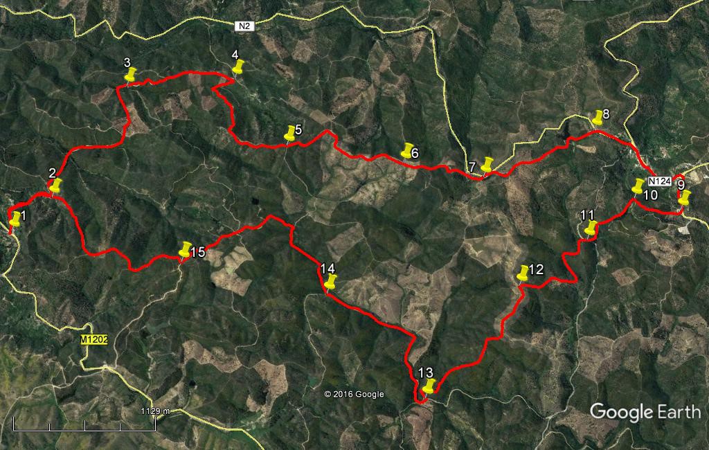
The Walk.
- Walk up the road past the Barragem sign (1), through a small group of houses, over the hill and down slightly. Where the tarmac ends, (280m) ignore a turn left on tarmac and go straight ahead on a dirt track, downhill into a shallow valley. Find some road signs at the bottom (this is a public road), and swing left following the sign to Corgas Bravas. (360m) (2)
- Walk along, first southwest and soon due west, descending slowly into another shallow valley. Go round a fairly sharp right hand bend to start walking gently uphill northwestwards. (450m) At the top of the rise swing round left and walk west, ignoring a track down to the left. The track then turns southwest and descends very gently down to another tight bend to the right. Go round to face northwest again and climb, steadily at first, then more steeply (ignore a track on the right soon after the turn.) (1.13k)(3).
- At a T junction see a sign to Panela left, and stay right to arrive after 1k at a junction with road signs, one left to the N2, one ahead to Corgas Bravas. (see the buildings of the hamlet ahead) (4)
- See a narrower, rutted track going off downhill on the right, and take this, descending to a stream or dry bed. (140m) Go straight across and ahead, ignoring a turn left. Swing round left very soon and climb steeply. Starting off just east of north, the track turns more to the northeast and becomes very steep for a time. Turning just west of north, continue to rise more steadily to reach a high point (5).
- Walk along an undulating ridge from here, heading first northwest and then due north, ignoring all tracks leading off left downhill. Reach point (6) (1.22k) which is a junction with a track on the left, and continue just west of north. Ignore tracks to left and right, start to descend a little and wind rather more. Come to a point where a main road is visible a few metres to the left. Go straight on here and soon arrive at another point close to the road. Go out onto the road this time (780m) (7). and turn right uphill round a bend.
- On the straight, find a dirt track between trees on the right, (130m) and follow this as it bends left and runs northwest, roughly parallel with the road, into and out of one shallow valley, then down more steeply into another, crossing the retaining wall of a small barragem. Climb briefly from here to reach the road again, (1.1k) (8)
- and turn right up it to reach the village of Barranco do Velho. Pass the junction with the N124 signed to Loule, and walk up the hill right through the settlement until you reach another main junction on the right, with the Bar- Restaurant Tia Bia on the corner. (900m) Refreshments may be had here before starting the return leg.
- To return to Cova da Muda, turn right out of the Tia Bia, along the 124, direction Cachopo. Walk along to find a large white house on the right, with a curved roof projection and the letters JAE below it. (350m) (9) (This is one of a number of properties used in former times to house the men who were in charge of road maintenance.)
- Walk down the left- hand side of this building and follow the path continuing in a straight line from there, downhill, then up and over another rise, to descend quite steeply to join another track at an acute angle (410m) (10).
- Walk forward a few yards and swing sharply left onto a wider track that descends gently and then continues on level ground. The track forks just short of a tarmac road. Take the right fork uphill to meet the road and turn right up it. (600m) (11)
- Walk a few metres before turning off left on a track that immediately divides. Take the left hand path as it winds down into a valley. It runs northeast, then southeast into the valley, then northeast again for a time, rising gently. See the tarmac road you crossed, over to the left, and follow the track as it swings sharply round to the southwest (530m) and climbs steeply. The incline becomes more gentle as the track rises by long ´steps´ to reach a high point (550m) (12).
- At the T junction facing you, turn left. The track swings due west very quickly, and begins to descend almost imperceptibly. Ignore a turn to the left and follow this track as it turns rather more southeast and descends, winding quite a lot, into a valley. After a final sharp turn, and a stream or dry bed crossing in the valley, it joins a much wider dirt road at a T junction. (1.45k) (13)
- Turn right and climb round a right hand curve. At a junction follow the sign to Menta as the track runs southeast, then turns due south, along a valley. After some time, come to a junction with a sign to Perro Sancho on the left. (1.5k) Stay right on the main track and start to climb once more, first southwest, then due south, then southwest again, to reach a junction with a track on the right. (690m) (14) Turn left here with the wider track, and follow it due south, then due east, then southeast. This is a wide public road, so easy to follow.
- Reach a point where a road sign indicates Cova da Muda straight on, and turn right away from the main track. (1.13k) (15) (The sign takes you to the main road and a long walk on tarmac)
- Now follow an undulating track leading back to Cova da Muda. First south, then southeast, at a junction turning southwest again, then due south. Stay right at the next junction and descend steeply now on a stony path, down to a junction. (1.65k) This is point 2 on the outward leg. Turn left to make your way back to Cova da Muda and your car. (650m)
Orientation: South is left.
GPS Points: 37// 7
| 1 | Cova da Muda | 11 | 56 | 59 | 53 | 55 | 74 | |||
| 2 | Track division | 12 | 00 | 02 | 54 | 13 | 00 | 650m | ||
| 3 | Track junction | 11 | 58 | 62 | 55 | 01 | 09 | 1.65k | ||
| 4 | Nr Corgas Bravas | 12 | 24 | 17 | 55 | 24 | 10 | 1.1k | ||
| 5 | Summit junction | 12 | 49 | 15 | 55 | 12 | 23 | 1.4k | ||
| 6 | Track junction | 13 | 19 | 10 | 55 | 28 | 19 | 1.2k | ||
| 7 | Join N2 | 13 | 39 | 78 | 55 | 39 | 08 | 750m | ||
| 8 | Join N2 again | 13 | 59 | 20 | 56 | 14 | 73 | 1.2k | ||
| 9 | Road mender´s house | 14 | 30 | 16 | 56 | 05 | 43 | 1.3k | ||
| 10 | Turn to main track | 14 | 18 | 33 | 56 | 00 | 97 | 430m | ||
| 11 | Tarmac road | 14 | 12 | 83 | 55 | 39 | 73 | 580m | ||
| 12 | Track junction | 14 | 03 | 02 | 55 | 13 | 12 | 1.1k | ||
| 13 | Track junction | 13 | 57 | 37 | 54 | 24 | 71 | 1.5k | ||
| 14 | Fork in track | 13 | 20 | 43 | 54 | 36 | 39 | 1.5k | ||
| 15 | Right turn | 12 | 42 | 67 | 54 | 19 | 01 | 1.9k | ||
| End | 2.3k |