Walk Thirty Three. Cortinhola - Zambujal. 18.5 kilometres. Ascent: 800 metres.
GPS: 37/ 16 46 80 8/ 06 41 48
This is a strenuous walk, and very much a walk of two halves. After climbing to a low ridge above the small settlement of Cortinhola, the walk descends into and along a long valley leading to the isolated village of Zambujal. It then follows the valley as it narrows, before rising to a high ridge and descending again to the hamlet of Aguas Frias. Then it climbs to the ridge once more, and descends, before a final shorter ascent to a lower ridge leading back to the start. There is a short cut from Zambujal for those not wishing to attempt the high ridge and a car may be placed at Aguas Frias for anyone wishing to end the walk there.
Getting to Cortinhola.
From the south and west. Use the 124 or the IC1 to get to Messines. Drive in the direction of the A2 and Salir to arrive at the roundabout before the motorway. Turn left here, and at the end of the long straight, facing a restaurant, turn right onto a road which is the M542. This will take you all the way to Cortinhola, a winding but very attractive country road, passing numerous villages. An alternative, better for those coming from Loulé and points east, is to take the M525 north from Loule to Salir, driving round Salir to reach the 124. Turn left at the 124 roundabout and then look for a sudden turn on the right, after a bend, signed to Sobradinho and Cortinhola, among other places. Turn left at Sobradinho to reach Cortinhola. The lane up to the start is the third turn on the right - Rua da Escola - after the hairpin turn onto the M542. Park opposite a burned-out building (probably the old school-house).
To get to Aguas Frias by road, continue along the road from Cortinhola to Azinhal, turning right there to go over the hill and down to Aguas Frias.
Refreshments.
There is a bar at Barrosas, a couple of kilometres east of the start-point on the main road through the valley, and there is a bar at Aguas Frias.
The Walk
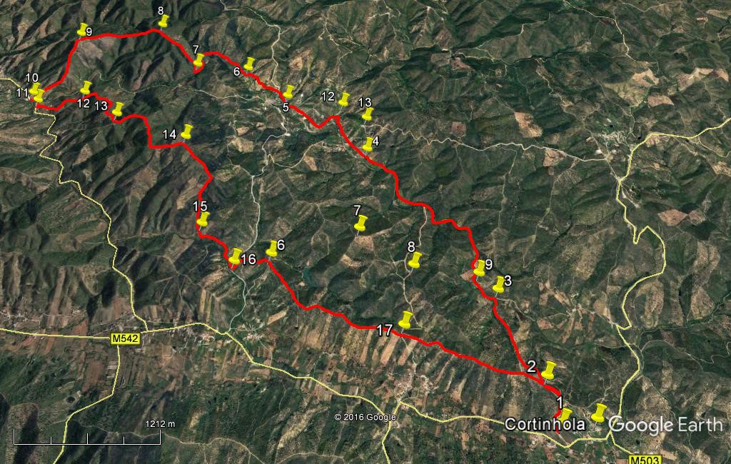
- From the parking area on the hill (1) above the main road turn uphill and walk to the ridge and over the top to a junction, turn left here and after a short distance fork right (2) to descend into the valley.(480m) Follow the main track down to the valley floor and a much wider track which is a public road. There are four small water-crossings, with rough stepping stones, on the next section. In wet weather, or after heavy rain, these could be troublesome.(3) (960m) Turn left and follow the road, which eventually becomes a tarmac road, at the tiny settlement of Corte Bucho. (4) (2.5k) Continue on the road as it follows the course of the river, around a tight left-hand bend and on to reach a bridge on the left, below the small village of Zambujal (5). (1.47k) If you wish to take the short cut, cross the bridge and walk up the tarmac road which, after a long climb, will bring you out close to Point 16, where you can climb to the ridge for the return. Go straight on past the bridge, and where the main road turns uphill, keep to the valley along a much narrower dirt track. This leaves the river for a time, but returns at a ford (6). (750m) Stay on the same side of the river, following the path as it soon describes a wide sweeping curve to the left around the head of the valley, and then bends less widely to the right.
- Coming out of this bend, find a track leading off uphill at an acute angle to the right, almost due north. (7) (1.1k) Climb steeply on this track as it turns north-west to reach a summit (8) (780m) Bear left from here and soon sharp left to follow the ridge line just south of west into a depression and up again to a second summit (9).(1k) Take the left fork near the summit to go to the very top. Turn left here, over the summit (no apparent track as you go over), and find a track descending steeply due south. Halfway down, (320m) fork left and descend to a tarmac road at the valley floor, at the settlement of Aguas Frias. (630m) The bar is directly opposite as you reach the road.(10)
- Turn left along the road, round a tight bend over a bridge and then take the second turn uphill on the left, (11) (190m) on a concrete road, up to and past a small group of houses. Bear left up a lane after the first buildings (170m) with very large cacti on the left and a small palm on the right, and follow this as it climbs up to a ridge once more.
- Halfway up the hill, (460m) find a fainter track going off left, (12) heading north of east for a summit. (White property boundary marker ´AM`at junction). Follow this round to the right (south-easterly) on the ridge line as it rises to a high point, undulating south-east, then due south, then south-east again, to reach another high point after (780m from 12) (13). From here swing left and follow the track, still on the ridge, round a wide curve, after which the track turns almost due south and then due east, to reach point 14 after a further 1.19k. (White property boundary markers ´AM`and ´JG`at summit). You now have sight of a tarmac road in the valley to the left. Turn right from here to walk south-eastwards for a further 560m, the track still undulating. At a fork bear right and turn more to south-west, descending steeply to reach another fork after 220m. Take the left hand track here and continue to descend, due south now, to reach a wider track after another 420m. (15) Turn left along it, joining a tarmac road after 530m. Go straight ahead on the road and take the first left, leading uphill (100m) (16). Attaining the ridge, go along to a major track junction after 420m, taking the exit straight across, bearing south-easterly. Now follow this long ridge back towards the start, staying all the time on the ridge-line. Go straight across once more at a cross-tracks (1.58k) (17) above the village of Sobradinho in the valley to the right, and arrive back at Point 2. (1.35k) Go straight on here and take the first right round the corner and back down to the start point. (480m).
Orientation normal.
GPS Points. 37// 8
| 1 | Start | 16 | 46 | 80 | 06 | 41 | 48 | |||
| 2 | Fork into valley | 16 | 59 | 42 | 06 | 44 | 33 | 480m | ||
| 3 | Valley road | 17 | 26 | 79 | 06 | 57 | 07 | 960m | ||
| 4 | At tarmac | 18 | 21 | 44 | 07 | 46 | 26 | 2.5k | ||
| 5 | Zambujal bridge | 18 | 46 | 41 | 08 | 22 | 96 | 1.47k | ||
| 6 | Ford | 19 | 00 | 91 | 08 | 42 | 94 | 750m | ||
| 7 | Bottom of climb | 19 | 03 | 27 | 09 | 07 | 57 | 1.1k | ||
| 8 | Top of climb | 19 | 20 | 96 | 09 | 26 | 96 | 780m | ||
| 9 | Second summit | 19 | 15 | 30 | 10 | 04 | 97 | 1k | ||
| 10 | Village | 18 | 48 | 79 | 10 | 21 | 53 | 960m | ||
| 11 | Turn off tarmac | 18 | 45 | 27 | 10 | 18 | 34 | 190m | ||
| 12 | Fork on hill | 18 | 47 | 25 | 09 | 56 | 27 | 630m | ||
| 13 | Ridge 1 | 18 | 35 | 23 | 09 | 37 | 70 | 780m | ||
| 14 | Ridge 2 | 18 | 23 | 16 | 09 | 04 | 15 | 1.19k | ||
| 15 | Down from ridge | 17 | 50 | 67 | 08 | 52 | 75 | 1.2k | ||
| 16 | Before climb | 17 | 36 | 78 | 08 | 37 | 76 | 630m | ||
| 17 | Cross-tracks on ridge | 17 | 14 | 36 | 07 | 32 | 93 | 2k | ||
| End | 1.83k |