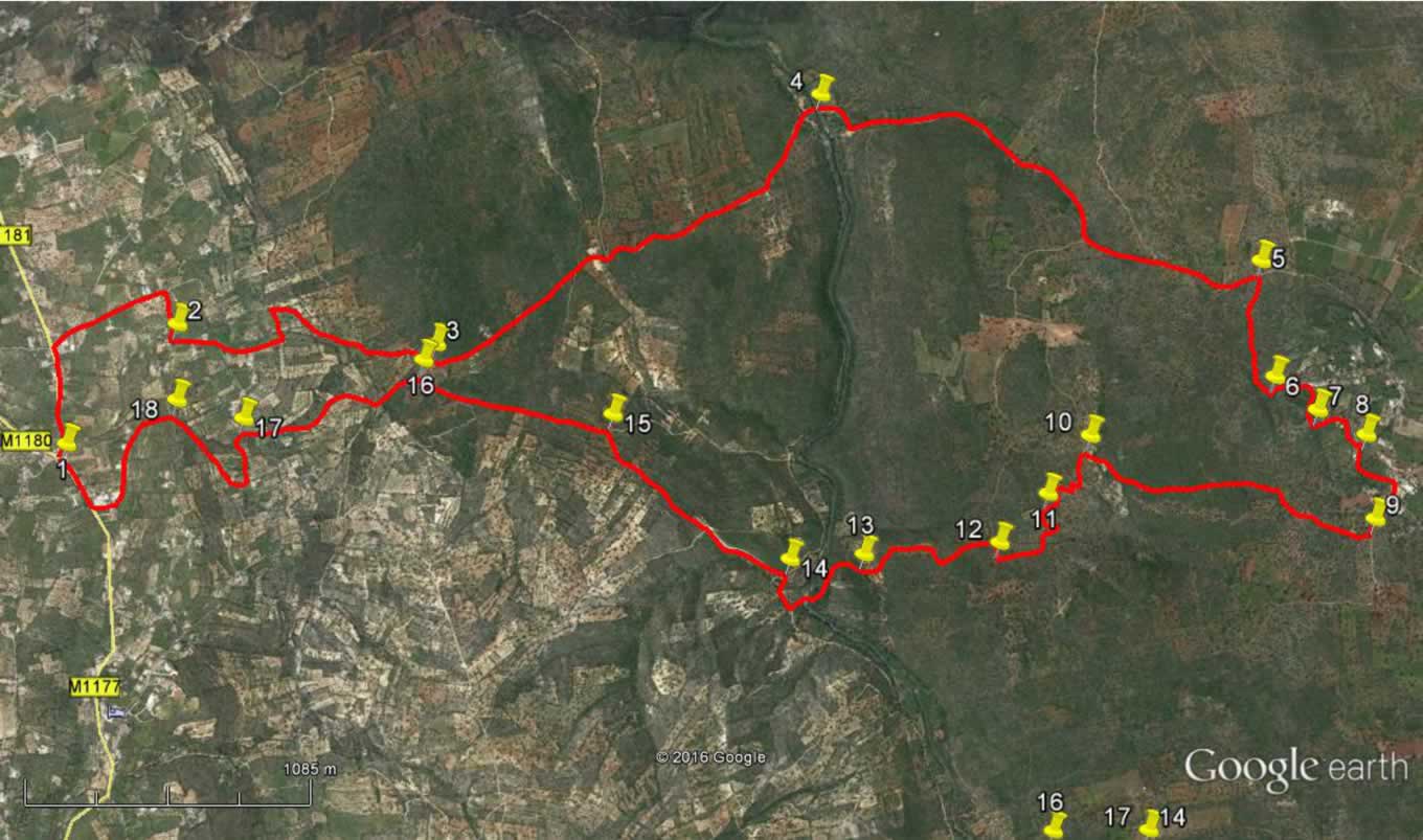
Walk Five. Alfontes - Espargal. 15.5 kilometres. Ascent: 550 metres.
GPS: 37/ 09 21 31 8/ 07 43 75
This is quite a tough walk in spite of being relatively short, because it involves a long steepish climb on the way out, and a shorter but steep ascent on the way back. It starts from a well-known ex-pat bar in the village of Alfontes, close to the A22 motorway, descends to the Rio Algibre and climbs to the hilltop settlement of Espargal, before returning to the start on a course a little to the east of the outgoing track. There are no refreshment facilities on route, and the bar at the start does not usually open before 10.00. There is another bar close at hand that should be open, but if you are missing your Guinness or Caffreys, Coopers should be open on your return!
Getting to Alfontes.
Leave the A22 at the Boliqueime exit and follow signs to Loulé to turn back over the motorway. See a petrol station on the left and turn left past it. Follow this road as it turns uphill. Alfontes is the first settlement you come to, and Coopers Bar is on the right hand side, over the crossroads as you come to the centre. If you have one car, you could park in their parking area. Otherwise the area opposite can accommodate two or three vehicles, as long as you do not park in front of the garage doors. The other bar, for early coffees, is on the right as you come up to the cross-roads.
The Walk
- With your back to Coopers, (1) turn right across the road and walk along the tarmac to the next turning on the right, by a restaurant. (450m) Go up this road and take the second turning on the right, (500m) along another surfaced road. Take the next turn on the left (200m) (2).
- Come to a right-hand curve (170m) and see a lane going down to a house on the left. Before reaching the house gates, fork left off the lane onto a field track, keeping close to the right, heading due north.
- Pass a building on the left and continue on the same line to a field corner, turning left and following the line of bushes down to a wide dirt track. (330m) Turn right and walk down the track past one main junction on the left and coming to another one the right. (720m) (3)
- Anyone having second thoughts about the walk can turn right here, walk a short distance to point 16 and follow the instructions from there to return to the start.
- To continue, stay left and follow the track as it descends and then levels out. Pass a set of three large charcoal ovens on the left. (260m) Head somewhat west of north, passing a cross tracks and a clear turn to the left. Come to a junction where a wide track leads off to the right, but your track heads off more westerly and descends to the Rio Algibre. Swing round to the right as you get to the valley floor to see the crossing, with the end of a tarmac road visible on the other side. (4) (1.7k)
- Cross the river. The Algibre is very often completely dry, but after heavy rain there could be quite a lot of water. Do NOT attempt to cross if it is fast-flowing, but if shallow, the river bed has been flattened and the crossing is easy.
- Now walk along and up the tarmac road. Pass a turn on the right after 1.35k and then look out for a turning on the left after a further 600m which goes downhill and then up to a building and enclosure. Soon after this, (120m) find a dirt track on the right (5) and follow this as it ascends, at first gently but then more steeply, working up and across the face of the hill.
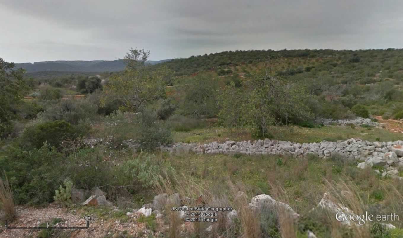
Typical landscape on the way down to the river.
- After around 400m the track moves away from the due east direction and begins to wind, turning more north-easterly. After about a further 110m, the track appears to end in a small clearing. Go forward and look for a narrow footpath heading due north uphill. (6) Stay right at one junction, then come to a wider track. Keep right again and walk up and over the brow of the hill, to come up alongside a large house with a garden enclosure in front. (160m). Opposite the house turn right and walk on a path through an orange grove. At a junction after 100m, turn left downhill. (If you turn right, a few strides will lead you to a trig pillar and a splendid view – then return.) Turn left again after a further 100m, and descend to a house, passing this to the left and dropping further to a junction below. (150m)
- Turn right. Follow this path with a fence on the left. It turns gently to the left and then descends steeply down rough steps to wind through houses (it looks as though you are crossing their yards) to reach a surfaced road that hairpins down to tarmac (8). (180m)
- Go down the road in the same direction, bending round to the left to drop down to a junction. Turn right and then bear right to pass to the right of the old village primary school (Escola Primaria). Stay left at the next junction and soon come to the start of a gravel track. Take the first turn to the right. (460m) (9)
- Follow this track as it undulates along the hillside, heading something west of south, and eventually descending to a large house. (1.1k) Walk past the house and at the first junction (10) swing round to the left and start to descend. The track now becomes quite stony and descends through hairpin bends, heading south-east.
- Reach a shallow valley at an open space (500m) (11). Turn left and left again as the track briefly turns north and then hairpins south again, arriving at a much wider track running east-west.(420m) (12) Turn right along for 100m, looking for a less obvious track on the left heading due south, and turn onto this.
- This slightly overgrown track leads after 300m to an open area dotted with trees, quite obviously cultivated. Follow the track through this area going south for just over 200m – it shows as vehicle tracks here - and find the exit from the grove in the bottom left-hand corner. Cross another short open area and come to a junction with a track coming in from the left, turning right. (160m) (13)
- At the next junction keep left. The track bends round to run south-eastwards and drops to the valley. Bear round to the right on level ground to find a tunnel of tall reeds leading to the river side. (320m) Cross here diagonally right to the track on the opposite side. After a short distance bear right onto a wide track running along the valley. Go round a bend to the right and very soon come to a track on the left leading uphill away from the river and turn onto it (240m) (14)
- The track rises steeply to a junction, heading southwest. (380m) After the junction continue on the same line, now on more or less level ground. At a T junction with a wider track turn left (580m) (15). Head now west of south in a straight line, rising gently. Pass a junction with a track on the right, (800m) heading back northwest. (16) (This is the linking track mentioned as an escape route early in the walk).
- The next junction is a complex of paths, after a further 210m but simply bear right through it, starting southwest onto a track that rises quite gently, curving round to the left and then straightening out due south once more. Pass a junction with a house on the left. Finally reach another junction at a sharp left hand turn (17).
- Continue along the track as it swings left again and climbs towards buildings on the left. Reaching them, (220m) swing round in a semicircle here to face southwest, (avoiding two turns to the left in the process) and follow the tarmac road uphill.
- Come to a cross-roads (450m) and go straight across, over the brow of the hill. Walk down the road to a T junction (580m) and turn right to walk down to Coopers on the left at the next junction. (230m).
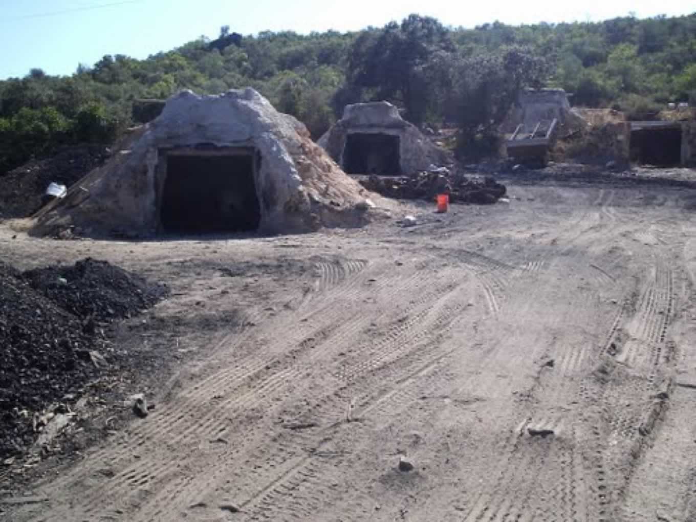 The charcoal ovens.
Orientation. Left is South. 37/8
GPS Points.
| 1. | Coopers Bar | 09 | 31 | 20 | 07 | 43 | 75 |
|
||
| 2. | Turn left | 09 | 47 | 75 | 08 | 00 | 65 | 1.16k | ||
| 3. | Linking track | 10 | 19 | 78 | 07 | 52 | 81 | 1.28k | ||
| 4. | River crossing | 11 | 13 | 13 | 08 | 26 | 44 | 2.00k | ||
| 5. | Turn off tramac | 12 | 05 | 83 | 07 | 50 | 26 | 2.1k | ||
| 6. | Turn up to Espargal | 12 | 04 | 57 | 07 | 31 | 63 | 490m | ||
| 7. | Turn after trig | 12 | 09 | 18 | 07 | 25 | 68 | 320m | ||
| 8. | At tarmac in village | 12 | 15 | 54 | 07 | 20 | 80 | 290m | ||
| 9. | Turn after Espargal | 12 | 15 | 77 | 07 | 07 | 29 | 480m | ||
| 10. | Hairpin ater house | 11 | 41 | 62 | 07 | 25 | 69 | 1.21k | ||
| 11. | Turn near grove | 11 | 35 | 80 | 07 | 17 | 09 | 410m | ||
| 12. | Track after grove | 11 | 29 | 08 | 07 | 09 | 99 | 410m | ||
| 13. | Junc. before river | 11 | 11 | 61 | 07 | 10 | 49 | 730m | ||
| 14. | Turn from valley | 11 | 01 | 93 | 07 | 11 | 12 | 540m | ||
| 15. | Junc. on level | 10 | 41 | 26 | 07 | 38 | 14 | 970m | ||
| 16. | Link track | 10 | 17 | 89 | 07 | 50 | 51 | 790m | ||
| 17. | Left turn | 09 | 54 | 61 | 07 | 44 | 36 | 760m | ||
| 18. | Crossroads | 09 | 46 | 55 | 07 | 48 | 57 | 620m | ||
| End | 820m |