Walk Thirty One. Cerca Velha – Paderne Castle – Alfarrobeira. 15 kilometres Ascent: 350m
GPS: 37/ 10 26 84 8/ 11 32 45
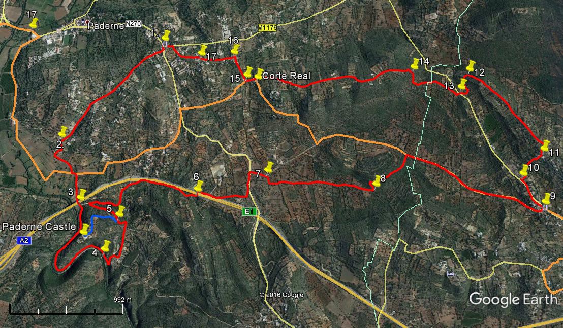
This walk begins in the Cerca Velha ´suburb´of the small town of Paderne, in the south of the Algarve but north of the tourist zone. It takes in a visit to the remains of the castle overlooking the Rio Algibre, one of the few standing relics of medieval times in the region, before re-crossing the A22 motorway to take a wide swing to the east through farmland and small settlements, returning over a high ridge with spectacular views to the north, and passing close to the Corte Real Gallery, one of the main fine art sales and exhibition venues in the area.
Getting to Cerca Velha.
From the south, the easiest way is from the N125 at the junction with the N395 Albufeira – Paderne road. GPS: (37) 07 07 59 (8) 14 46 39. Follow the 395 north through Ferreiras and passing over two motorways, to arrive just north of Paderne in the settlement of Purgatorio. Turn right here to cross the river into Paderne and follow the main road through and up the hill out of the town. When the road levels out, look for the bar-restaurant ´O Alagar´ with its distinctive yellow awnings, on the left. Best parking just before it on the right. If this bar is not open, there is another one a few hundred metres up the road on the left just after it.
From the north, and west, follow the N124 past Messines and up the hill after the A2 motorway exit. Come to a small roundabout and turn right for Paderne on the N270. Arrive at Purgatorio and turn left across the river, then follow as from the south above.
The Walk
- With your back to the bar, (1) turn left and walk for 100m before taking the first turn on the right, along a narrow tarmac road. Follow this road between houses and then into more open country descending steadily southwest, passing several turnings on both sides. After 1.22k, pass a turn on the left rising gently, with a 3.5ton warning sign. Take the next turn left down a narrow gravel lane between low walls, (2). Go down here turning right after a house and swinging round in a semicircle to walk southeast then south to arrive at a T junction. (440m from 2) Turn left and then quickly right, then walk down and under the motorway viaduct ahead. (340m) (3)
- Go straight ahead after the viaduct, following a path alongside the river. At the weir on the river you can cross if you wish and if the water level allows, as there are paths on both sides of the river. Follow your chosen path as it describes a curve, following the line of the river through a gorge. Arrive at a bridge (Roman origins) (1.2k on the inner curve, longer on the outer) (4) and cross if you crossed the weir earlier. Go straight on (or turn right) and climb on a wide rocky path, round a hairpin and up to a T junction. Turn left and walk over the rise, down gently to a sharp left-hand bend. 100m further on see a fork off to the left. (580m)(5) This will take you up to the castle ruins if you wish to view them. Then you must return to this spot. (Round trip is 1.14k, shown by the blue line)
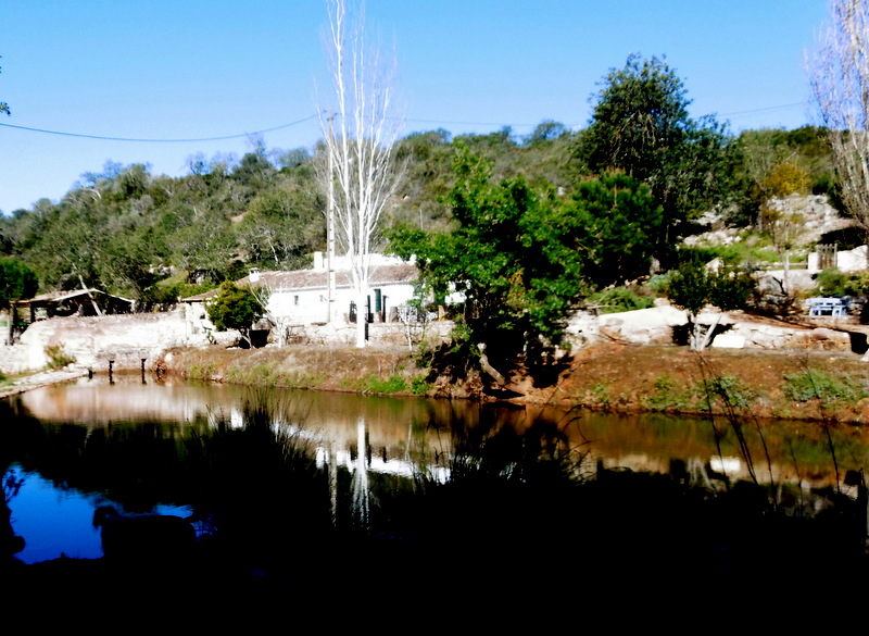
At the weir below Paderne Castle
- To continue, go downhill to the valley floor and round the hairpin bend at the bottom, continuing ahead on this track that leads up to the side of the motorway. (1.08k) Do not cross the bridge but stay on the right hand side and walk along to find a track going left under the motorway. (6) (560m) Continue in the same direction beside the motorway on the other side. Ignore a turn to the left,continuing on the same line on a tarmac surface. (560m) Go left (north) after 120m and then first right on another tarmac road. At the first bend, turn off right (7) (340m) onto a gravel track. Follow this, passing to the left of a small building, and around 35m after this turn left and walk due east, following a hedge and tree line across rough land, some of it possibly ploughed. After around 300m, find a much more obvious track continuing in an easterly direction. Follow this as it soon crosses a track coming in from the north.
- After a further 500m, find another track coming in from a northerly direction and turn onto it. After around 80m it swings round eastwards again, passes an old threshing floor on the left and then turns more north-easterly, to reach a tarmac road after another 420m. (9) Turn right along the road and walk for around 1.3k to arrive t a junction with a restaurant opposite (´O Lavrador´) Turn left here and follow the road for c330m to find a turn to the right (10)with red and white hunting signs on both sides.
- Go up here, swinging left quite soon and then right, past one house on the right and later others on both sides. Find a turn the left (360m) (11) on a bend opposite a farmhouse (small green roof on one of the buildings), and take this new track as it leads uphill, bearing round to the right and then turning left through 90 degrees at the top of the rise. (110m) Now follow this track as it goes very gently downhill along the crest of a broad ridge, heading northwesterly.
- After c1k, where the track begins to descend more steeply, (12) swing round left across the top of an open field to find tracks running round and down the hill almost due south to reach a tarmac road (340m) (13). Take the gravel track opposite, heading southwest then northwest and beginning to climb. The path turns southwest again and then due north. After 600m from point 13, come to a fork and take the left-hand (main) track uphill. (14) Swing left, at the top of the steep climb, to follow the broad dirt track down another long ridge, with spectacular views of the country to the north.
- After passing three or four dwellings or groups of houses, come to the beginning of a tarmac surface and find a lane leading off to the left. (1.6k) This takes you very quickly to the Corte Real Gallery (open Thursday to Sunday, light refreshments at weekends), well worth a visit to see the high quality paintings and ceramics on display and for sale. Otherwise, or afterwards, continue down the road, taking the first on the right in front of a large new villa. (15). Go down into a village and turn first left, then quickly right, and finally left again (290m) (16) Follow the road until reaching a fork (270m) (17), where go right downhill. Stay on this road, descending more steeply as you go, to reach a junction, turning left to descend to a main road. The café from which you started is immediately on the right. (350m)
Orientation Normal.
GPS Points 13/ 8
| 1 | O Alagar | 10 | 26 | 84 | 11 | 32 | 45 | |||
| 2 | Turn towards river | 09 | 56 | 05 | 12 | 12 | 03 | 1.41k | ||
| 3 | Under motorway | 09 | 36 | 42 | 12 | 03 | 78 | 800m | ||
| 4 | Roman Bridge | 09 | 20 | 78 | 11 | 53 | 72 | 1.28k | ||
| 5 | Castle visit | 09 | 30 | 91 | 11 | 48 | 81 | 550m | ||
| 6 | Motorway crossing | 09 | 38 | 02 | 11 | 18 | 89 | 1.61k | ||
| 7 | Turn off tarmac | 09 | 43 | 29 | 10 | 52 | 19 | 900m | ||
| 8 | Left turn | 09 | 38 | 36 | 10 | 11 | 37 | 1.08k | ||
| 9 | Restaurant | 09 | 31 | 94 | 09 | 09 | 27 | 1.95k | ||
| 10 | Right turn | 09 | 40 | 03 | 09 | 16 | 49 | 320m | ||
| 11 | Alfarrobeira | 09 | 47 | 26 | 09 | 08 | 02 | 360m | ||
| 12 | End of ridge | 10 | 13 | 88 | 09 | 31 | 94 | 1.11k | ||
| 13 | Road crossing | 10 | 08 | 10 | 09 | 25 | 82 | 330m | ||
| 14 | Bottom of climb | 10 | 14 | 70 | 09 | 54 | 00 | 600m | ||
| 15 | Turn after gallery | 10 | 13 | 20 | 10 | 59 | 53 | 1.73k | ||
| 16 | Turn in village | 10 | 21 | 35 | 11 | 04 | 53 | 280m | ||
| 17 | Turn downhill | 10 | 20 | 99 | 11 | 17 | 49 | 320m | ||
| End | 430m |