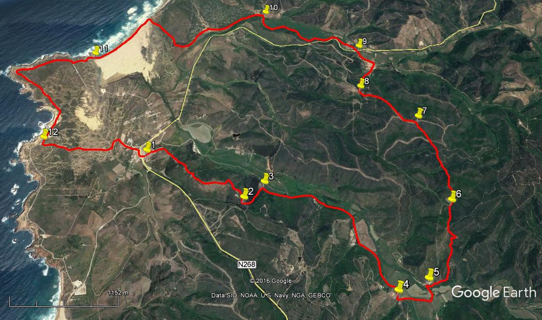
Walk Thirty. Carrapateira – Bordeira Circular. 18.5k. Ascent: 456m.
GPS: 37/11 00 54 8/ 53 41 37
One of many wonderful walks on or near the west coast of the Algarve. Starting from the village of Carrapateira, now a centre for the surfing business, it runs away from the coast and over hills with views of the sea, before descending to the settlement of Bordeira, where there is a bar. It then turns back to the sea, and ends with a walk along Bordeira Beach and a cliff stroll before turning back to the start. Refreshments at the start and in Bordeira. This walk was led by Antje Whittle for the AWW.
Getting to Carrapateira.
From the east, use the A22 motorway to its end near Bensafrim. At the roundabout, take the left hand road, signed to Aljezur. After running along the valley, the road winds and climbs towards a set of wind turbines. At the summit, take the left hand turn, signed to Monte Ruivo and Alfambras. At the next T junction turn left again, brown sign to Sagres. Now simply follow this road, first very straight, then comes a long and winding descent. Finally the road runs along the valley, past the entrance to Bordeira village and round bends to end with a long straight into Carrapateira. Best parking is to go over the rise and almost past the village, to turn sharply left into the market square. Travellers from the south could use the N125 and N268 from Vila do Bispo.
The Walk.
Carrapateira
- With your back to the Market Hall and the public toilets, (1) turn left and walk up the hill, passing to the right of Café Bravo. Go straight ahead at the first junction, then turn right to wind through narrow alleyways to reach a wider tarmac road coming up from the left. Turn right to walk along the Rua do Estado, with houses on the right and a seaward panorama on the left. Continue on this route as the houses end and the road turns to a track 330m from the start.. Climb the hill in front to reach a trig pillar, and continue, generally south-west, through quite a deep depression, climbing again afterwards. After crossing the moor top, the track starts to descend quite steeply. Come to a cross-tracks and go straight across on a rough track, descending to a junction. (2) (1.83k from the start). Turn left here to continue going down, now through a tree-lined valley.
- Reach level ground after 350m and see a high wall on the right. (3) Take the path immediately alongside it to walk through trees, joining a wider track after around 340m. Go ahead on this for a further 1.94k, passing a riding establishment on the right (Herdade de Becudo). Arrive at a junction with a road coming down from the right and dwellings up on the hill (4) and turn left to follow the road across the valley in front. After around 380m turn left at a junction and shortly turn left again to walk down to a stream crossing. Almost immediately turn sharp right (5) to enter another track, passing to the right of a group of houses.
- After running level for a short time, the track begins to climb. Pass a ruined building on the right after 370m, and continue just east of north. The track continues to climb and eventually turns right and then goes through quite a sharp left-hand bend to resume the previous course. Soon after this come to a fork, with a small barragem or dam straight ahead (not immediately visible from the track). (6) Take the right hand track past the barragem and continue due north and then slightly west of north. Reach level ground at another fork after 740m, and walk more or less on the level for a further 490m to reach a junction with another track. (7) Turn left.
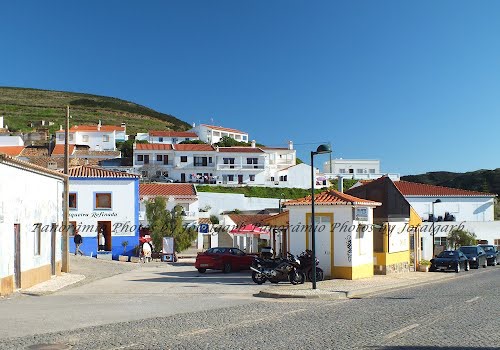
- Walk on this steadily descending track for around 930m. A barragem appears down on the left, with a track going down to it. Take the next turn on the right, (8) a narrow track that will take you quite quickly down into the village of Bordeira. Walk down the main street to find a café on the left, with a pleasant seating area just across the road if all you need is a rest.
- To continue the walk, leave Bordeira by carrying on along the main street past the café, taking the first left to pass to the left of the church. Walk along the tarmac road to the junction with the main road (9) and go straight across onto a dirt track. At a fork soon after, take the left hand track, which roughly parallels the main road for around 750m before leaving it to run along the edge of a wide flat meadow. At the end of the meadow the track turns north along the boundary. Do not take the first turn on the left, but cross the stream or dry bed and take the left turn on the opposite side. (10) Swing left with the track to follow the line of the stream, walking through pine woods with sand underfoot. After around 1.36k, come round a corner with buildings ahead, walk along to the next corner on the track, where it turns north, and then walk due west over the low sand dunes onto the open beach.
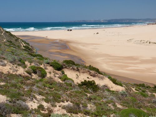
Bordeira Beach (Praia de Bordeira)
- Walk along the tide line across the beach. Find a rough track leading up the cliff on the other side (11) and walk up to join a boardwalk, turning left along it to reach a dirt road and car parking area. Walk up the road to a junction and turn right to walk around the edge of the cliff. After 2.42k find a track on the left leading away from the cliff back towards Carrapateira (12). Walk along here as it descends. The track crosses a stream bed, rounding a sharp right hand bend and shortly afterwards becomes tarmac surfaced. At the junction with the main road turn right to walk over the rise and back to the village centre, your car and the bar. (1.59k from point 12.)
Orientation Normal. GPS; 37/8
GPS Points.
| 1 | Carrapateira | 10 | 59 | 96 | 53 | 43 | 38 | |||
| 2 | Before descent into wood | 10 | 39 | 24 | 52 | 51 | 82 | 1.93k | ||
| 3 | Turn to wooded path | 10 | 46 | 34 | 52 | 42 | 56 | 350m | ||
| 4 | Junction | 10 | 03 | 69 | 51 | 45 | 22 | 2.3k | ||
| 5 | Right turn by house | 10 | 07 | 80 | 51 | 31 | 02 | 570m | ||
| 6 | At barragem | 10 | 35 | 89 | 51 | 15 | 31 | 1.21k | ||
| 7 | T junction | 11 | 13 | 56 | 51 | 22 | 91 | 1.26k | ||
| 8 | Turn to Bordeira | 11 | 29 | 78 | 51 | 50 | 47 | 930m | ||
| 9 | Bordeira cross-roads | 11 | 54 | 48 | 51 | 47 | 40 | 930m | ||
| 10 | Ford | 12 | 17 | 14 | 52 | 40 | 78 | 1.8k | ||
| 11 | End of beach | 11 | 52 | 59 | 54 | 18 | 20 | 3.1k | ||
| 12 | Clifftop turn | 11 | 07 | 73 | 54 | 34 | 77 | 2.6k | ||
| End | 1.54k |