
Walk Twenty Nine. Cai Logo – Foz do Ribeiro Circular 17 kilometres. Ascent: 650 metres.
GPS: - 37/ 17` 08.99 8/ 11´12.07 NOTE. This Walk has been edited. See Point 9 onwards.
This walk is a combination of high-level and valley walking in unspoiled country in the north of the Algarve. It starts and ends in the tiny (one or two houses) hamlet of Cai Logo, and travels over the hills to a welcome bar and lunch stop in the scattered village of Foz de Ribeiro. Spectacular views for much of the day.
Getting to Cai Logo.
From the A2 motorway or the N125, take the IC1 north to Sao Bartolomeu de Messines. At Messines, follow the N124, signed to the A2 and Salir, to the next roundabout. Turn left here, signed to Messines. At the end of the long straight, turn sharp right, into the Rua Fonte Joao Luis. Follow this road (it changes name several times, but is numbered M542) for just over 9k to find tiny Cai Logo – there is a boundary sign. Past a house with a verandah on the left, round the bend see a small fonte (well) and a large rubbish bin. Park here.
It is quite possible, and for some perhaps preferable, to start the walk from Foz de Ribeiro. In this case, you do not need to go down to Cai Logo on the outward leg. Simply turn back sharply uphill at the first fork described after Cai Logo, and continue from there. For directions to Foz de Ribeiro, see Walk Nineteen – Gralha.
The Walk
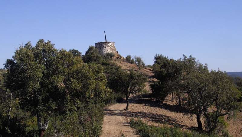
Ruined windmill above Foz de Ribeiro
- Turn to face the house you have just passed, (1) and take the narrow road on the right, climbing up the hillside.
- After about 200m, find a fainter, rather weed-strewn track on the right climbing steeply, and follow this until it joins a much more obvious track after another 220metres. Turn right here. Now follow the track as it climbs less steeply, for a further 760 metres, ignoring turns to right and left leading downhill. (2) Notice the white column of trig point Pedreira over to your left.
- Now the track levels out and describes a semi-circle round the head of a valley over the next 720 metres or so. Ignore all turns to the right on this section as the path heads first just north of east, then swings round to end north-west. The apex of the curve is the high point of this section of the walk, followed by a steady descent to point 3. The curve ends and straightens to run almost due north for the next 400 metres (3) At the fork here, take the left-hand option.
- The next section of the walk consists of a tramp along an undulating ridge. After turning to face south of west for a short time, the track runs north-west to point four, descending, over a distance of 1.1k (4)
- and climbs once again, turning to just west of north, to the trig column Pereiro Alto, after another 1.13k (5)
- Follow the ridge line taking care not to leave it either left or right, until just below the trig point, where a track forks off to the left. Follow this track, descending gently, and take the right fork after 180m, heading north-west then almost due west. After another 220m ignore a turn right and one left, to continue northwesterly to the right of trees for a further 100m, descending. (6)
- From here continue northwesterly, beginning to descend more steeply, for another 300m, after which the track curves round to face due north and drops again over a further 300m.Now it turns quite sharply right and joins another one coming down from the right. Turn left and follow the track as it leads down to a small group of buildings and pass them on the right after yet another 300m, (7) at a junction with a much wider dirt road. Turn right down to the valley floor, cross a bridge over the river and join a wide road on the other side, turning left along it.
- This is a public road, so there will be the occasional vehicle. Turn left along it and follow it for 2.3k. First go past the little hamlet of Zebro do Baixo, round a wide curve to the left and then a hairpin to the right. A further wide curve to the left is followed by a long straight and then another left-hand curve (you are following the line of the river down this valley). Finally, at another sharp right hand turn in the road which now begins to climb, with houses above on the right, turn off left on a narrower track, (8) keeping to the same side of the river.
- From here to the bar at Foz de Ribeiro is a straightforward walk of 1.8k along this track. It roughly follows the river line, then crosses it and continues down to Foz do Ribeiro, re-crossing the stream shortly before reaching the village. The Bar is on your left as you come to a tarmac road at a T junction. (9) Lunch can be had here. (pre-ordered).
- For the return leg, retrace your steps from the bar for 700m, recrossing the stream. Ignore the first turn to the right, and take the second one, (10a, see detail photo below) which leads uphill for 300m southwest to join another track. Turn left.
- Pass a turn to the right, and after 100m come to a junction with tracks left and right. (11). (Please see second photo below to find the revised route detail.The revised route is shown in yellow.) Go straight on, past another track on the right as the track turns first due south, then southeast and then due south again to reach a junction with a wider track after around 350m, climbing all the way. Turn left here, swinging round a curve, to reach a high point after another 340m. (12) Go straight ahead from here, following the track as it begins to descend steeply, alternating east and south-east, for around 540m.
- At the bottom of the slope turn through 90 degrees right, ignoring an obvious turn on the left, so now heading just east of south. At a fork after around 320m, bear left Now follow the track as it rises rather more steeply, over two long ´steps´ to reach another high point after just over 500m. (13)
- Take the left fork again, go over the summit and drop down, now facing roughly east. After turning quite sharply right, climb again to pass a ruined windmill before starting to descend once more. At the bottom of the steep slope, 730m from point 13, meet a wide dirt road and turn left along it (not up the track immediately left) (14) .
- Climb once again along the wide road, becoming steeper, running easterly at first, then turning northeast. After around 550m, it turns due north, at which point take a track on the right running north of east downhill to meet another wide track after around 250m. (15) Turn right along this and follow it more or less due east, first of all along a valley floor, rising very gently and then more steeply as it crosses a ridge before descending finally back to Cai Logo, passing the junction with the outward track as it nears the hamlet, a distance from point 15 of around 2.2k.
Orientation Normal.
GPS Points: (13//7)
| 1 | Cai Logo | 17 | 08 | 28 | 11 | 11 | 89 | |||
| 2 | Opposite trig | 17 | 36 | 77 | 10 | 50 | 90 | 1.22k | ||
| 3 | Track junction 1 | 17 | 59 | 64 | 10 | 48 | 17 | 1.13k | ||
| 4 | Track junction 2 | 18 | 19 | 55 | 11 | 15 | 54 | 1k | ||
| 5 | Trig Pereiro Alto | 18 | 51 | 89 | 11 | 30 | 82 | 1.19k | ||
| 6 | Descent to valley | 19 | 02 | 97 | 11 | 42 | 62 | 460m | ||
| 7 | Above Zebro do Baixo | 19 | 15 | 50 | 12 | 07 | 45 | 1.10k | ||
| 8 | Val Mos | 18 | 50 | 26 | 13 | 17 | 10 | 2.63k | ||
| 9 | Foz do Ribeiro | 18 | 46 | 46 | 14 | 14 | 37 | 1.78k | ||
| 10 | Steep climb to ridge | 18 | 34 | 44 | 14 | 04 | 63 | 540m | ||
| 11 | Track from left | 18 | 24 | 83 | 13 | 52 | 11 | 500m | ||
| 12 | High point 1 | 18 | 14 | 50 | 13 | 33 | 33 | 690m | ||
| 13 | High point 2 | 17 | 52 | 42 | 12 | 55 | 13 | 1.37k | ||
| 14 | Main track junction | 17 | 52 | 25 | 12 | 29 | 15 | 710m | ||
| 15 | Short cut to main track | 17 | 57 | 96 | 11 | 59 | 58 | 830m | ||
| End | 2.14k |
![]()
![]()