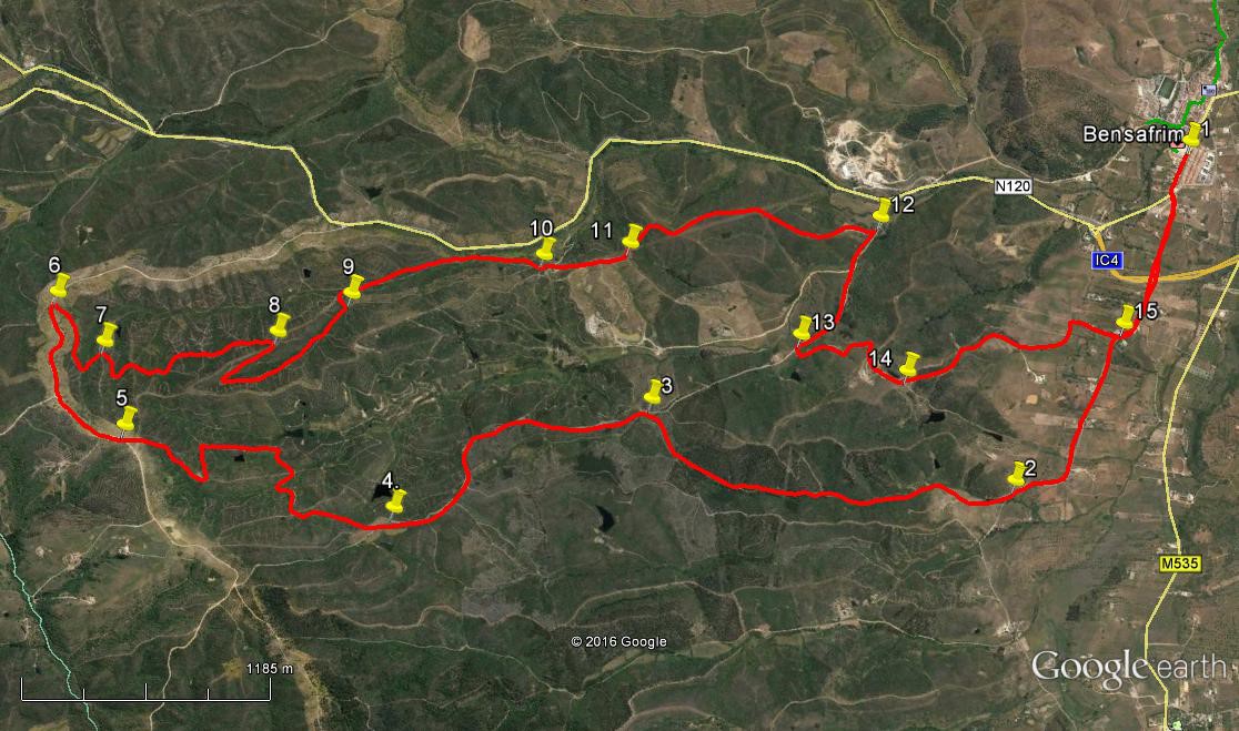
Walk Twenty Seven. Bensafrim Circular. 17.4k Ascent: 392m
GPS: 37/ 09 19 00 8/ 44 15 53
This is a fairly challenging walk in the hills and valleys north-west of the small market town of Bensafrim, located at the current end of the A22 motorway in the west of the Algarve. It takes in high ridges and attractive valleys, passing isolated homes and deserted buildings. I am indebted to Rod Frew for working out and leading this walk.
Getting to Bensafrim.
The only obvious way from the east is via the motorway. Pick it up at a convenient point and drive to the end. At the roundabout turn right into Bensafrim and drive down to the open square on the left, beyond which is the market building and a café. Park here to begin the walk. Coming from Lagos, take the N120 from the eastern end of the town, near the marina, signed to Aljezur. Follow this main road up into Bensafrim at the junction, and find the market square on the right.
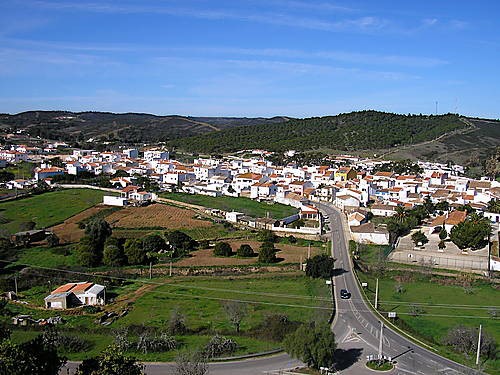
Bensafrim
The Walk.
- From the market square, go to the road and turn right. (1) At the first junction bear left and follow the road as it passes under the motorway, heading due west. Around 1.2k from the motorway, the road bends to the right. Take the second track on the right after this turn, heading north-west. (2) After about 270m turn right off this track, which leads to a building, and follow a narrower path as it starts to climb, heading first north-west then due north up a valley. There is a water crossing to be made on this section, if there has been heavy rain, but it should not cause problems. Ignore a steep turn to the right, staying on the main track. After 2k, the track swings round north-eastwards and comes to a junction, with a ruined building over on the left. Turn left (3).
- The track continues to climb, west of north, for a further 940m, then turns briefly south-west to reach a high point, before swinging round to face north-west again and beginning to descend. Come to a point with barragems (small dams) on either side of the track (4), and take a narrower track due north. After less than 100m, bear left with this track and then take the second clear track on the right, heading due north once more. Follow this as it rises gently over a further 370m, to reach a five-way junction of tracks. Take the second on the right and descend slowly on a winding route over another 460m, heading generally north-east, to come down to a sharp left-hand turn quite close to a little group of barragems, one quite large. Turn left with the track and walk roughly north-west, passing another barragem on the left, turn sharply south-west and then northeast by a rebuilt house, finally heading due north to reach another junction, having climbed quite steeply towards the end, over a distance of 1k. (5)
- Bear right at the junction and continue due north for a short time. Then the track begins to curve right. Ignore a clear turn to the left after around 400m, and continue to turn with the track until facing due east on the crown of a bend after another 500m. (6) Here find a track leading off left, and another, a few metres further on, doubling back south-west on the right. Take this one and after around 300m follow it as it makes a wide turn through 180 degrees to face a small barragem below, and arrive at a five-way track junction. (7) Take the second on the right, briefly due south and then on a winding course southwards, undulating, with higher ground to the right and a deep valley on the left. Around 1k from point 7, the track turns through a hairpin bend to face north-west. This climbs fairly steeply over 320m before turning very sharply again to run south-eastwards once more. After a further 720m, descending steadily, arrive at a cross-tracks (9). Turn left and follow across another cross-tracks, (another possible water-crossing here) to emerge very soon at a junction with a broader track. Turn right.
- Follow this track for almost 1k, first south-east and then due south as it runs very close to a main tarmac road for a time, before bearing away again to come down to a junction, with buildings ahead and on the left. (10). Pass round immediately to the right of the building straight ahead, and take the track beyond and follow it south-east over a low hill, to arrive at another junction (11) after 430m. Turn left and follow as the track describes a semi-circle to end up heading south-east and then due south over a further 1.4k, passing a trig pillar and then descending fairly steeply, to arrive at another junction soon after passing a villa, with the main road down to the left, and a large industrial complex visible beyond (12). Turn right and head due west uphill, ignoring a turn to the right but taking the first on the left after 750m. (13) heading briefly towards a barragem before turning south-east.
- Ignore a turn to the right after 540m, and continue as the track turns due south and passes a long narrow barragem on the left. Immediately after this bear left at a fork (14) and follow this track as it descends all the way to the valley floor and joins your outward track on tarmac at (15). Turn left to follow the road back into Bensafrim, the bar and your car. (1k)
Orientation: Left is north. GPS: 37/8.
GPS Points.
| 1 | Bensafrim Market | 09 | 19 | 00 | 44 | 13 | 64 | |||
| 2 | Turn off tarmac | 09 | 21 | 22 | 45 | 29 | 54 | 2k | ||
| 3 | Track junction | 10 | 18 | 68 | 45 | 45 | 63 | 2k | ||
| 4 | Turn by barragems | 10 | 47 | 62 | 46 | 26 | 34 | 1.53k | ||
| 5 | Main junction | 11 | 30 | 21 | 46 | 33 | 82 | 1.83k | ||
| 6 | Turn off main track | 11 | 49 | 08 | 46 | 16 | 44 | 880m | ||
| 7 | Multi junction | 11 | 39 | 07 | 46 | 21 | 21 | 520m | ||
| 8 | Sharp turn NW | 11 | 15 | 59 | 46 | 05 | 08 | 1k | ||
| 9 | Turn across vallwy | 11 | 08 | 02 | 45 | 52 | 22 | 1.1k | ||
| 10 | Nr buildings | 10 | 43 | 55 | 45 | 29 | 21 | 1.1k | ||
| 11 | Track junction | 10 | 32 | 13 | 45 | 19 | 88 | 430m | ||
| 12 | Junc after villa | 09 | 58 | 25 | 44 | 53 | 73 | 1.41k | ||
| 13 | Nr building/barragem | 10 | 01 | 68 | 45 | 21 | 64 | 750m | ||
| 14 | After barragem | 09 | 44 | 37 | 45 | 19 | 27 | 760m | ||
| 15 | Tarmac junction | 09 | 16 | 25 | 44 | 52 | 16 | 1.26k | ||
| End | 1k |