Walk Twenty Six. Benafim – Alto Fica – Nave dos Sobreiros Circular.
12 kilometres. Ascent: 175m. With Nave do Barão extension, 17.5k and an extra 200m of ascent.
GPS: 37/ 14 00 63 8/ 07 15 31
This is an easy walk from the large village of Benafim, across the valley to the south, up and along the higher ground beyond, and back via the small settlements of Alto Fica and Nave dos Sobreiros. There is one short section of difficult navigation, but careful compass or GPS work will see you through. Refreshments at the start and at Alto Fica. An extension is available and described, taking you into the Nave do Barão valley, where there is another bar.
Getting to Benafim.
Benafim Grande, the southern part of the village, lies astride the main N124 road that runs east-west across the Algarve. Access the village either from the IC1 junction at Messines, turning right along the 124 and passing through Alte, or from the A22 motorway Boliqueime exit, turning right for Loulé, passing the quarry, turning left for Parragil, then left again at the T junction for Alte and Benafim. On reaching the village, go to the eastern end to find a roundabout, with two cafes on the right just beyond. Park here to start the walk.
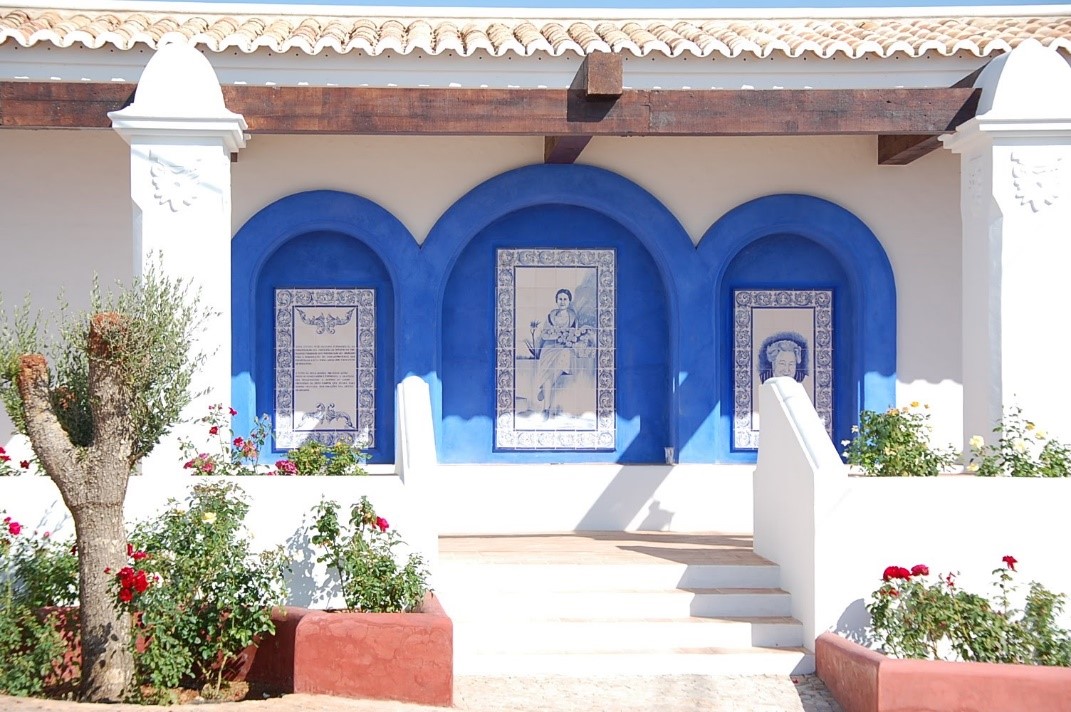
Patio Dona Antonia, Benafim. A new community meeting space, dedicated to a well-known local lady.
The Walk.
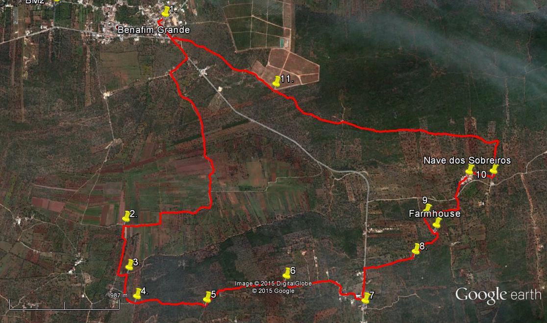
- With your back to the café (1) turn left and go left again at the roundabout to walk downhill on a main road. Straight on at the first main junction, then take the next obvious turn on the right going downhill, signposted Etar de Benafim. (440) After around 230m, turn left (carrying straight on would take you to the village Etar, or sewage treatment plant) and follow this track down into the valley. On level ground pass a building on the right, pass one narrow path on the left and arrive at a junction with a tarmac road. (1.21k) Go straight ahead on this, and follow it round a 90 degree turn to the right, continuing round a further right-angle left and yet another right.
- Now look for an obvious turn off the main track on the left, (2) heading straight between cultivated areas. (1k). The narrow road quite soon chicanes left and right and then after 450m find a dirt track on the left. Turn here. The track soon bends left and shortly after that find a narrower path off to the right, rising very gently. Follow this path up to a junction with a tarmac surface once more and turn left, continuing to rise. Ignoring a sharp turn on the right, come quickly to a 90-degree bend (410m) (4) and go straight ahead onto a rough track between walls.
- Walk almost due eat along this path for around 65om. Come to a junction (5) and turn left to walk gently downhill and then on more or less level ground for a further 780m. Arrive at another junction, with a better-surfaced track and turn right (6). Again on level ground follow the track, ignoring all turns to the left, to meet a tarmac surface and houses. (490m) Follow this road as it winds between the buildings to arrive at a main road in the village of Alto Fica. (350m) The bar in the settlement can be found a short distance down the road to the right. (7)
- To continue the walk turn left and walk on the main road until you have passed a large two-storey house with railings along the first floor balcony. (240m) After a few metres take a track leading off on the right, heading in a straight line due east, then deviating a little north of east. The obvious track becomes more faint, then see a large ruin over to the left. (300m) Stay close to the trees on the right as you pass, until faced with a line of low trees/bushes. (150m) (8) Find a narrow twisting path heading north-east through rocks and scrub. This path had become quite overgrown recently (May 2016). The path begins to descend and then drops quite steeply to an open field dotted with trees. Stay close to the left hand side of the field to reach an opening on the left onto a narrow tarmac road, close to a farmhouse. (410m)
- Turn left past the farmhouse and walk to the next turn to the right, (180m) 9) a narrow rough track leading to a small ruin. Walk towards the ruin, turning right just before reaching it, to find a low wall heading more or less easterly. Stay on the south side of the wall and follow it through three fields (you may have to weave a little to avoid bushes etc, but keep the wall in sight). Come to a lane between walls and walk up it, turning left through 90 degrees at a junction to reach a tarmac surface. (450m) Cross the road and take the narrower tarmac surface heading into the small village of Nave dos Sobreiros. (You can walk round the settlement on the main road, but it is quite a pretty place.) Wind through the village, heading first north-east and then turning south-east to exit. (480m)
- Just after the very last house on the left, which stands on its own, take a track on the left which leads off from the road as it turns at right angles. (10) This runs on level ground for a short time and then begins to climb. 340m from 10, find a track on the left and take this as it runs due west for a while and then more north-west. It rises gently over 2.2k and then (11) reaches the corner of a large orange grove. Pass to the left of the grove as the track descends to reach a main road. Turn right and then right again at the roundabout to return to your starting-point. (1.2k)
Orientation normal. There are two images for this walk, the second covers the extension.
GPS Points. 37// 8.
| 1 | Start/finish | 14 | 00 | 07 | 07 | 15 | 18 | |||
| 2 | Turn off valley road | 12 | 59 | 20 | 07 | 30 | 16 | 2.81k | ||
| 3 | Turn uphill | 12 | 45 | 12 | 07 | 28 | 62 | 560m | ||
| 4 | Turn on rough track | 12 | 36 | 92 | 07 | 25 | 80 | 300m | ||
| 5 | Join clear track | 12 | 36 | 11 | 07 | 00 | 54 | 650m | ||
| 6 | Right turn for Alto Fica | 12 | 42 | 54 | 06 | 31 | 69 | 760m | ||
| 7 | Alto Fica Bars | 12 | 35 | 02 | 06 | 03 | 10 | 830m | ||
| 8 | Start of twisting path | 12 | 48 | 80 | 05 | 44 | 23 | 770m | ||
| 9 | Turn to ruin | 13 | 00 | 11 | 05 | 39 | 54 | 530m | ||
| 10 | Uphill after Nave dos Sob | 13 | 11 | 91 | 05 | 14 | 36 | 920m | ||
| 11 | Orange grove | 13 | 38 | 22 | 06 | 34 | 12 | 2.56k | ||
| End | 1.2k |
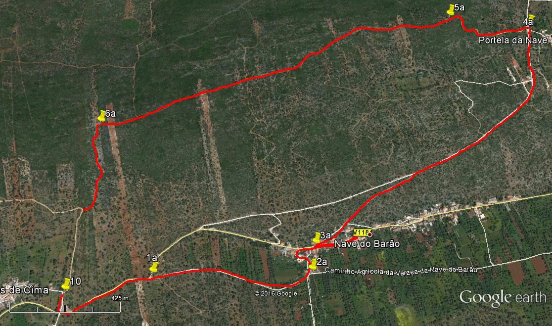
Nave do Barão Extension.
This takes you down into a fertile valley and the small community of Nave do Barão, which has a bar. From there, you climb out onto the hills again to the hamlet of Portela da Nave, turning there to make your way back over the moors to Benafim.
- From Point 10, turn right along the tarmac, and left at the main road. The road runs level for a time and then starts to wind and descend. After 380m, find a narrow metalled lane on the right, (1a) descending, and take this down to the valley floor. If walking in spring, look for the wonderful flowers here, especially the poppies. After 730m arrive at a turn to the left by a large blue and white painted house. (2a). Turn here and make your way through a group of houses up to a main road through the village.
- If you want to visit the bar, walk along the road for 230m, finding it on the right. Then return towards the point where you came out onto the road. Just before reaching it, see a short row of houses on the right, raised up from the road. Go up to them and pass in front, heading east, and find a lane starting at the corner, heading uphill. (3a) Follow this as it soon turns into a rough footpath, heading north-east. After 470m it emerges onto a narrow tarmac road. Walk up here to the hamlet of Portela da Nave, a further 660m. Come to a turn to the right on tarmac, that leads into the hamlet (4a) and see a track on the opposite side of the road (waste bins here too). Take this track as it leads quite steeply uphill, and becomes windy. The path bends quite sharply to the left after around 400m. Ignore a track going right uphill, (5a) and follow the main path westwards over the moor.
- After 1.6k, arrive at a broad stony track leading downhill (6a) and follow this down for 300m to find a track leading off westwards on the right. This is the track 340 m from Point 10 on the main walk. Follow the instructions above from there back to Benafim.
Orientation normal.
| 1a | Turn off road | 13 | 13 | 07 | 05 | 00 | 68 | |||
| 2a | Blue/white house | 13 | 12 | 50 | 04 | 34 | 91 | 700m | ||
| 3a | Lane uphill | 13 | 15 | 87 | 04 | 34 | 56 | 170m | ||
| 4a | Portela da Nave | 13 | 43 | 56 | 03 | 54 | 41 | 1.42k | ||
| 5a | Left fork | 13 | 45 | 05 | 04 | 08 | 67 | 410m | ||
| 6a | Downhill track | 13 | 33 | 97 | 05 | 08 | 21 | 1.58k | ||
| To link with main route | 300m |
Main Route