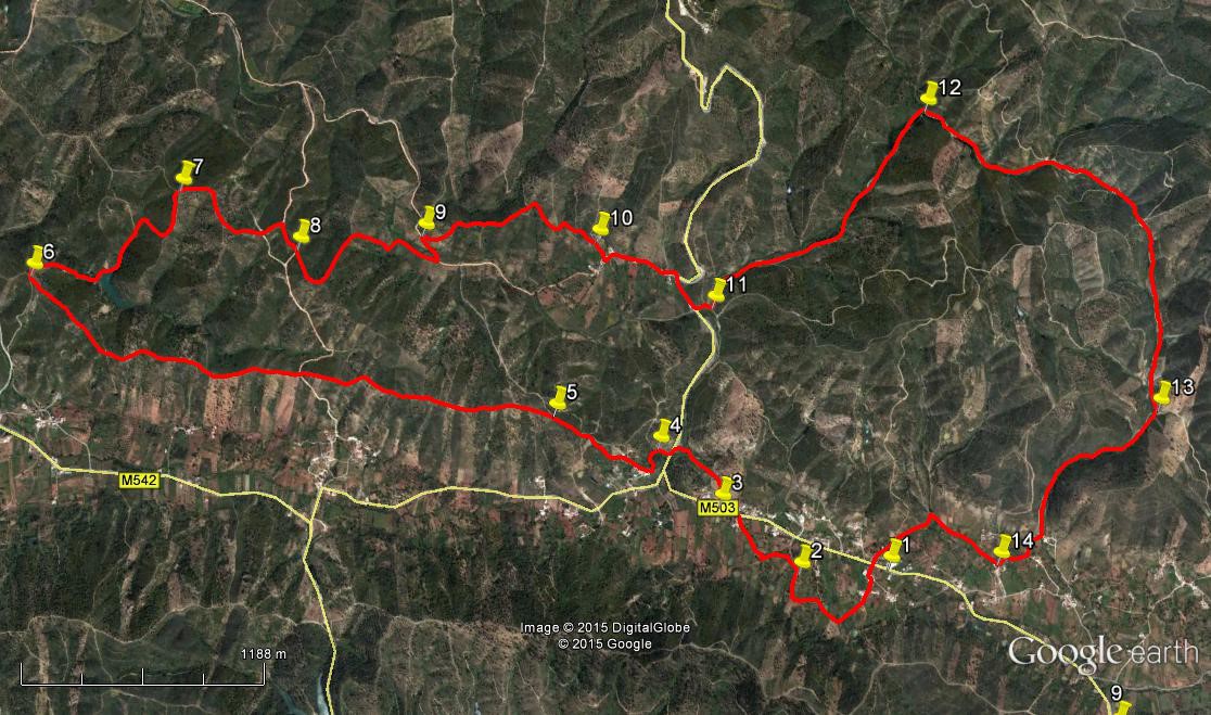
Walk Twenty Five Barrosas. 16.6 kilometres Ascent: 490 metres.
GPS: 37/ 16 24 46 8/ 05 43 74
Getting to Barrosas.
From all directions. Leave the A22 motorway at the Boliqueime exit and follow signs for Loule. After the large quarry turn left, and turn left again at the T junction in Parragil. Follow this road down into a valley and across a river, then up the hill, over and down into another valley, finally rising to the small town of Benafim. At a fork in the road on the outskirts take the right hand (straight on) up to a roundabout. Go straight over and follow this road, following signs for Sobradinho and Cortinhola. Go past Sobradinho and at Cortinhola come to a junction. Take the right, signed Loule and Salir. The Bar Paraiso da Serra is 1.3k along from here on the left. Park here, or as near as possible. Driving distance from the Boliqueime exit is around 24k. Alternative from the west is to use the N124 from Silves or Messines. At the motorway roundabout after Messines, turn left as though going into the town. Turn first right, signed to Fonte Joao Luis, and follow this road for 18k, heading for Cortinhola. At Cortinhols, turn right at the T junction, and the bar ia a further 1k along on the left. From the east come up from Loule to Salir and take the 124 westbound, turning off right for Barrosas about 1k from the roundabout.
The Walk.
- With your back to the Bar, (1) turn right and walk to the first turn on the left. Go along this lane, staying right at the first fork and right again at the second. Note several small dams, or barragems, on your left. At a third fork, the track bends sharply right. Go round and walk forward, passing a barragem on the right and one on the left. Immediately after the second one, turn left and walk just north of east across the open land, about 10 metres from the hedge line surrounding the barragem. After about 60 metres, pick up a field track going the same way, and shortly come to a more obvious track running east of north. Turn right and walk around 100 metres to a building (2) following the track round it to the left. After a further 100m, come to a junction of tracks. Swing round to the left in front of a tree sitting in the middle of the junction and head off in a generally westerly direction along another dirt track.
- About 150m from the tree, find a narrower track on the right going north, and turn onto it, shortly passing between two barragems and eventually reaching buildings. Emerge onto a tarmac road after around 250m. Turn left along the road and take the second turn on the right, past a house with a stone-clad boundary wall, into a lane going uphill. (3) Follow this as it climbs and curves to the left, passing between some ruins and a barragem, then descending (less well-defined) back down to the tarmac road (470m from 3). Cross the road diagonally to enter another lane on the opposite side and walk along this for around 100m. Find a narrow path leading off on the left, (4) climbing the hill to buildings visible on the skyline (direction south-west). Climb through trees to reach the first buildings, which are ruins. Go past on the left and turn right to walk for a short distance to a surfaced lane. This is the small settlement of Cortinhola.
- Turn right up the lane and follow it as it climbs and becomes a dirt track Over a summit ti drops briefly to join another track coming in from the right. (370m from Cortinhola). Walk forward, ignoring a track going down on the left, and at a fork after a further 220m, take the left hand uphill.(5). Now follows a 2.9k stride along an undulating ridge. Keep to the ridge path, ignoring all track leading off downhill. Arrive at a point which is clearly the end of the ridge, with views down into valleys on three sides. (6) You have descended to a multi-way junction. Take the first on the right, a narrower path that cuts off a bend and drops to join a wider track heading first due east then south-east, steeply down to a fairly large barragem in the valley. (370m from 6).
- Turn left in front of the barragem and work round the edge, leaving it behind as the path begins to climb quite steeply. At a fork after 320m take the right hand path, and go right again, very steeply upwards, at the next junction after a further 100m. Arrive at another ridge-line after another 160m, and turn left. Climb again, less steeply, for a further 230m to reach a summit, and turn right. (7). Descend for around 140m, turn right and climb again for about 230m to a second summit. Fork left here and descend again, crossing over one cross-tracks to reach a wide dirt road after 310m. Turn right and walk gently uphill for about 160m and at a bend (8) take a much narrower path on the left heading almost due south uphill to another summit after 140m.
- The path swings round to run north-eastwards, now descending. After 360m take the right hand at a fork and continue to descend, now heading south-east, to join a much wider track in the valley after a further 500m. Turn left and after 150m turn right ona narrower path that begins to rise once more, quite steeply at first and then more gently, to reach a high point after some 600m. It then turns downhill and descends steadily for around 540m to the small settlement of Pe de Coelho. (10). Go down to the tarmac road here and turn left.
- Walk along to the junction with a main road and turn right along it. Now take the first turn left after the junction on a dirt track. Soon turn right with the path and then first left to follow a path heading up the right-hand side of the valley floor. Now follow this path as it climbs gently up the valley for 1.54k. Reaching a T junction, (12) turn right to walk south-east, still rising, for 760m, and at another junction turn right to continue to climb, reaching one more summit after a further 580m. From here descend for 970m due south, and at the junction turn right (13). After a further 950m reach a junction and turn right once more (there is a fork about two-thirds of the way down this stretch- you can go either way).
- Follow the track as it turns sharp left, ignore a turn to the right and come to a T junction. Turn right here and follow the track into a small settlement, turning right again after the first house. (14) Walk along for 430m and where the track turns very sharply left, go with it and walk down to the main road, which is a further 410m away. Turn left to find the bar from which you started a few metres on the left.
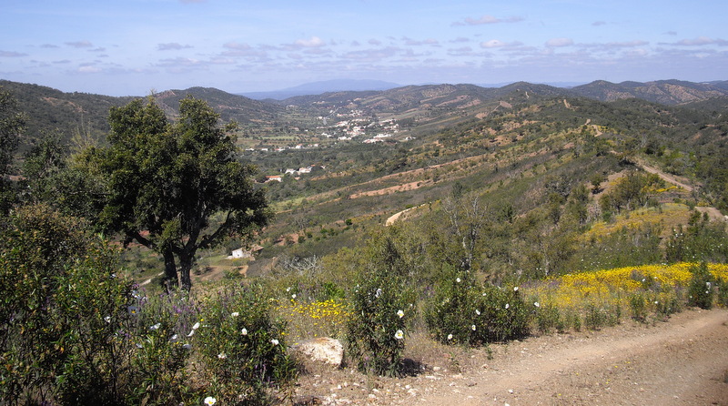
The Barrosas Valley in Spring. Monchique in the far distance.
Orientation normal. 37/ 8
GPS Points:
| 1 | Bar Paraiso da Serra | 16 | 24 | 46 | 05 | 43 | 74 | |||
| 2 | Left turn in fields | 16 | 26 | 42 | 06 | 01 | 84 | 870m | ||
| 3 | Turn off road | 16 | 39 | 71 | 06 | 14 | 91 | 600m | ||
| 4 | Turn to Cortinhola | 16 | 50 | 84 | 06 | 24 | 91 | 550m | ||
| 5 | On ridge | 16 | 59 | 37 | 04 | 44 | 26 | 700m | ||
| 6 | Above barragem | 17 | 38 | 36 | 08 | 23 | 21 | 2.92k | ||
| 7 | Turn after barragem | 17 | 46 | 68 | 07 | 49 | 24 | 1.18k | ||
| 8 | Turn off wide track 1 | 17 | 33 | 89 | 07 | 28 | 59 | 780m | ||
| 9 | Turn off wide track 2 | 17 | 32 | 40 | 07 | 03 | 54 | 1.14k | ||
| 10 | Above buildings | 17 | 25 | 76 | 06 | 28 | 74 | 1.1k | ||
| 11 | Turn up valley | 17 | 11 | 46 | 06 | 08 | 23 | 800m | ||
| 12 | At valley head | 17 | 35 | 76 | 05 | 18 | 44 | 1.6k | ||
| 13 | Fork on hill | 16 | 41 | 04 | 04 | 44 | 16 | 2.24k | ||
| 14 | Turn at farm | 16 | 21 | 56 | 05 | 21 | 55 | 1.3k | ||
| End | 930m |