Walk Twenty Four. Barranco do Velho – Cortelha. 15.5 kilometres. Ascent: 300 metres.
GPS: 37/14 24 53 7/56 14 35
This walk takes in a variety of countryside on the western edge of the high plateau north and east of the village of Barranco do Velho. The N2 road, running north from Faro, where Barranco do Velho sits, marks a kind of dividing line between the more populated central interior of the Algarve and the much emptier region to the east. After following the line of the road, the walk crosses over it to explore a few kilometres into this eastern wilderness.
Getting to Barranco do Velho.
One of the easier starting points to find. From the south take the Faro/ São Brás de Alportel exit from the A22 motorway, and travel north along the N2 up to Barranco via São Brás. At the junction with the N270 outside São Brás, go across at the roundabout, up the dual carriageway. Go right at the second roundabout, and left at the one after that, which keeps you on the N2 out of the town. After a long winding climb come at last to a junction with a turn left to Loulé/ Salir. Go straight on here, over two large road humps and up the hill. Find a café (Tia Bia – actually a pensão/restaurant, they have rooms) on the right at a junction turning right to Cachopo. Park here if visiting the bar. Coming from the west, take the N124 from any point from Silves eastwards, and stay on that road to Barranco. Turn left the junction with the Faro road (N2) to reach the café.
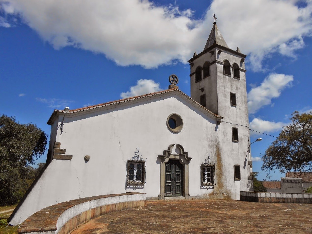
The church, Barranco do Velho
The Walk
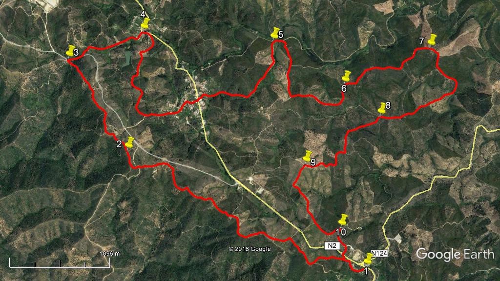
- From the café, (1) cross the N2 with the bar building immediately behind you, to find a path leading off uphill, to the right of the other café opposite the Tia Bia. Follow this path up to a gate, go through and up beside a large building on the right. Pass to the left of the church and then bear right towards the main road. Where tracks go down to the road stay left to follow the wide dirt track as it swings away, roughly north-westwards. (300m) This track now generally follows the edge of the plateau for around 4.2k., heading consistently northwest. Ignore a first turn left and a second going right down to the road. From there, follow the obvious main track, leaving left and right turns as you go. When you sight the white-painted base of a windmill ahead, go round the wide right-hand curve and up the hill to reach it. (3k from the church). (2) Pass to the right and continue along the track, again keeping away from the road. Descend through a wooded area to reach a patch of open ground with the road on the right and a turn downhill to the left at the far side. (3)
- Leave the track here and walk onto the road, turning right uphill. (This is not the N2, but a service road to a very large dump/recycling site, so the only traffic is bin lorries and such). Walk 150m to find a track on the left signed to Val Maria Dias, and take this as it leads downhill. Follow this very obvious dirt road (a public road) down to the hamlet of Val Maria Dias itself, joining a tarmac surface near the first houses. Go down to join a main road (the N2) and turn right along it for a few metres before taking the next right uphill, signed to Barragem. (770m) (4)
- Stay on the road, which quickly becomes a dirt track, up the hill and onto open heath, turning from southwest to due south. Ignore various turns right, which lead down to the barragem, and arrive at a major track junction with a little island of vegetation in the middle of the track. (1.2k) Turn left here and follow the track over a rise and then down into the village of Cortelha, which sits astride the N2. Turn right down the hill onto the main road, which you should join at an oblique angle to the main road, with waste bins near the junction, and a narrow road leading off on the other side between cottages. (630m)
- There is a café just along on the left, but to continue the walk go straight across up the narrow street, taking the first turn right onto a track which descends very gently to a junction with another track. (1.23k) (5) Turn right here and then very soon right again, rising steadily due south. Ignore a first turn left and come to a T junction, turning left and descending south of east. Walk along around a wide left hand curve to face due north, ignoring several minor turns to the left. Arrive at a fairly sharp right hand turn with another path going left. (920m) (6) Turn right and head alternately east and northeast, soon climbing again to reach a ridge.
- Arrive at a fork in the track and take the right, (1.1k) (7) swinging round almost in a semi-circle, staying right to beginning descending quite quickly, due south. Swing round south-east to descend more gently, then curve around to south-west to reach the valley floor. (650m) Here an obvious track leads off to the left, but you need to cross a small stream bed straight ahead and follow a less clear path running more or less south-west up a long incline to reach a ridge once more, veering west towards the top. As the path levels out, take the left hand at a fork, (860m) (8) turning south-west once more, then almost due south.
- At a three-way junction (650m) stay right along the ridge (west, then south), and as a path joins from the left, turn west and walk a winding ascent, passing three minor tracks on the left. Reaching a high point (540m) (9) turn left, west of south, beginning to descend very gently. Turn through 90 degrees at the next junction (250m) and follow the path roughly south-east then due south then a little more easterly again, now rising steadily. Swing briefly north-east, then right round a hairpin bend (800m) (10) at a junction to join a track coming in from the left. Turn right to reach the N2 (300m). Rather than walk down the road to the café, you can cross diagonally to a track, turning left very quickly to pass the church and walk down through the gate back to the point opposite the Tia Bia where you began. (360m)
Image orientation: Left is north
GPS Points: 37// 7.
| 1 | Tia Bia, start | 14 | 24 | 53 | 56 | 14 | 35 | |||
| 2 | Windmill | 15 | 07 | 24 | 57 | 51 | 88 | 3.36k | ||
| 3 | Road to dump | 15 | 39 | 15 | 58 | 15 | 54 | 1.21k | ||
| 4 | Val Maria Dias | 15 | 47 | 28 | 57 | 43 | 45 | 900m | ||
| 5 | Double right turn | 15 | 42 | 03 | 56 | 48 | 42 | 3k | ||
| 6 | Right turn in valley | 15 | 26 | 21 | 56 | 18 | 98 | 1.45k | ||
| 7 | Right curve | 15 | 36 | 82 | 55 | 42 | 15 | 1k | ||
| 8 | Fork on ridge | 15 | 14 | 53 | 56 | 04 | 87 | 1.55k | ||
| 9 | 3rd on left | 14 | 59 | 68 | 56 | 37 | 73 | 1.13k | ||
| 10 | Hairpin turn | 14 | 38 | 09 | 56 | 24 | 32 | 1k | ||
| End | 680m |