Walk 108. Espargal Circular. 16k. Ascent 450m.
GPS. 37// 12.19.78 8// 07.14.05
Introduction.
Please note: Navigation is a little tricky on some sections of this route. Follow the instructions carefully.
This walk starts and ends in the scattered hilltop village of Espargal, a few kilometres south of Alte. The 360 degree view from the summit is one of the best in the southern Algarve. The route winds south to the Ribeira do Algibre, and then follows the river for some time before turning north again, going as far as Nave dos Cordeiros before returning to Espargal. The ascents are fairly gentle, and the river bank walk a delight. There are no refrshments in Espargal, nor along the route, so a bar must be sought in Alte or Benafim. NOTE: There are a couple of river crossings on the route. After heavy rain, these may be impassable, so consult the forecast.
Directions to the start.
The easiest access to the village is via the M524 Boliqueime to Benafim road. Leave the A22 at the Boliqueime exit, and follow signs to Loule. Turn left after the quarry and left again at the T junction in Parragil. Now follow the road down to the Ribeira do Algibre and up to Alto Fica. Turn left to Espargal . 1,8k further on come to a junction and turn right. Stop and park here where you can.
The Walk.
Frrom the start to point 4, the trend is upwards. Then you will steadily descend to point 16, where the riverbank walk begins.
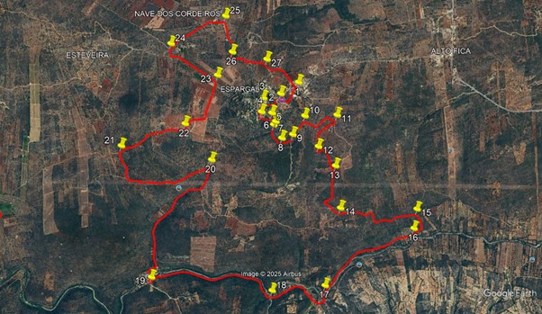
In front of you is a fork. (1). Take the left and almost immediately left again. Follow the road as it turns right and ends facing a house. (2). Turn left down a narrow entrance which leads into a wider dirt track, heading west. After 160m, the track turns left. (3). Walk south for about another 160m. Just after a house on the right, turn left (4) onto a narrow footpath through scrub. After 120m, turn right as the path turns south.(5). After just over 100m, the path kinks right (6). 30m further on (7) go left at a fork, and proceed along an even narrower track heading south.
The path turns more to the southeast, and after 190m, (8), turns eastwards. 130m further on, come to a wide dirt track and turn left along it.(9). Walk for 270m, and then turn right along a narrow track. (10). Walk for 160m southeast, then the same northeast, turning then right and come to a wider track at a junction, heading due north/south. (11). Turn right and after a short distance, then take the right at a fork. After 200m, this obvious dirt track ends. Now follow what is a tractor track due south for just over 200m. Here (12) pick up a footpath through the scrub, heading northeast.
The path soon turns south southeast, and after 250m crosses a plantation (13) and heads due south for another 300m before winding southwest and southeast to join another track after 340m. Turn left at the junction. (14). Now walk for almost a kilometre as this track heads eastwards on a winding course. At a junction with another track heading south, turn right (15). After 200m, turn right at a junction, and another 130m further on go left at a fork. (16). Now follow the track which is now running close to the river, for 1.3k, and coming down to a crossing point (17).
Cross the river here. Take the track immediately opposite and walk through bushes, turning right at a junction. The track now describes a wide loop away from the river, returning to it after a time, then leaving it again and once more coming back, a distance of 820m from the crossing. From here (18), the path hugs the river for another 1.55k. Come to a major junction (19). Here a wide track goes down to the river and a tarmac road begins on the opposite side. From here on, the trend of the walk is generally uphill. Walk up the road for 1.7k. Find a turn to the left which starts as tarmac but turns to a dirt road after a few metres. (20).
Walk along this track for 1k, and look for a narrower dirst track on the right heading almost due north. Follow this for 330m, arriving at a wider dirt track and turning right (21). After almost 800m, fork left up a narrow but obvious track (22) which soon joins a wider one. Walk for another 560m, and turn left (23) along a very straight track that passes between plantations. After 500m, the track kinks to the left. Soon after, find a narrow footpath heading north and take it, cutting off a corner to hit another wider track. (24). Turn right and walk on, passing close to a cluster of buildings off to the right.
After 570m, bear right to pass to the right of a group of buildings, reaching a junction after another 100m (25). Turn right and walk south for 200m, then bear right at a junction and after another 150m, turn left on a track (26). After 420m, this meets a tarmac road (27). Bear right along it, and after 500m, come to the end of the walk and your car.
GPS Points
| 1 | Ahead fork left | 12 | 19 | 78 | 07 | 14 | 05 | |||
| 2 | Turn left | 12 | 15 | 28 | 07 | 21 | 71 | 300m | ||
| 3 | Turn left | 12 | 14 | 63 | 07 | 30 | 14 | 250m | ||
| 4 | Bear left | 12 | 09 | 66 | 07 | 31 | 19 |
170
|
||
| 5 | Turn right | 12 | 09 | 04 | 07 | 26 | 60 | 120m | ||
| 6 | Turn right | 12 | 06 | 04 | 07 | 25 | 14 | 120m | ||
| 7 | Turn left | 12 | 04 | 94 | 07 | 26 | 07 | 50m | ||
| 8 | Bear left | 12 | 00 | 12 | 07 | 22 | 73 | 190m | ||
| 9 | Turn left | 12 | 01 | 24 | 07 | 17 | 71 | 140m | ||
| 10 | Turn right | 12 | 07 | 71 | 07 | 11 | 98 | 270m | ||
| 11 | Turn right | 12 | 07 | 50 | 06 | 57 | 49 | 450m | ||
| 12 | Turn left | 11 | 56 | 56 | 07 | 06 | 45 | 460m | ||
| 13 | Bear right | 11 | 49 | 29 | 06 | 59 | 12 | 350m | ||
| 14 | Turn left | 11 | 33 | 96 | 06 | 57 | 61 | 630m | ||
| 15 | Bear right | 11 | 31 | 94 | 06 | 22 | 05 | 1k | ||
| 16 | Turn left | 11 | 24 | 74 | 06 | 23 | 76 | 310m | ||
| 17 | Turn left | 11 | 05 | 24 | 07 | 05 | 88 | 1.3k | ||
| 18 | Straight on | 11 | 04 | 37 | 07 | 30 | 45 | 850m | ||
| 19 | Turn right | 11 | 11 | 40 | 08 | 25 | 82 | 1.5k | ||
| 20 | Turn left | 11 | 53 | 47 | 07 | 54 | 83 | 1.75k | ||
| 21 | Turn right | 12 | 00 | 28 | 08 | 35 | 40 | 1.3k | ||
| 22 | Turn left | 12 | 06 | 95 | 08 | 05 | 79 | 750m | ||
| 23 | Turn left | 12 | 23 | 87 | 07 | 50 | 22 | 720m | ||
| 24 | Turn right | 12 | 36 | 17 | 08 | 10 | 65 | 640m | ||
| 25 | Turn right | 12 | 45 | 42 | 07 | 45 | 41 | 740m | ||
| 26 | Turn left | 12 | 32 | 15 | 07 | 43 | 10 | 450m | ||
| 27 | Straight on | 12 | 28 | 60 | 07 | 27 | 64 |
420m
|
||
| End | 500m |