Walk 107 Aguas Frias - Cortinhola. 17kilometres. 725 m of ascent.
GPS: 37/ 18. 49. 89 8/ 10. 22. 78
Introduction.
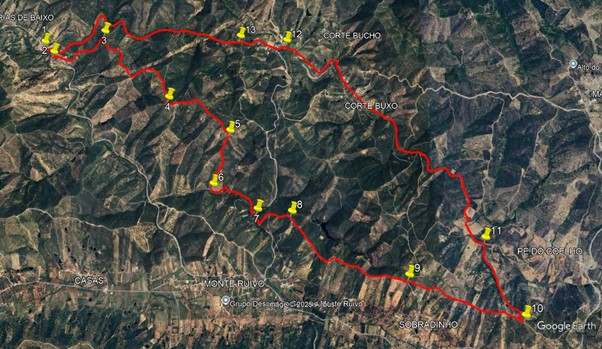
This challenging walk starts in the hamlet of Aguas Frias, in the north of the Algarve. The first part (7.5k), is a difficult route involving three significent ascents, travelling east to a point above the village of Cortinhola. An abrupt turn here sees a descent into a valley and a walk on level ground to Zambujal. A short climb into the village and a turn to the right leads to a track, again in a valley, taking you quite easily back to the start. There is a bar in Aguas Frias, but no other refeshment on the route.
Getting to Aguas Frias.
Take the N124 main road to Benafim. From the east, turn right at the roundabout in the village, from the west, turn left. Follow this road, signed to Sobradinho, among other destinations. Descending into the next valley, take a left and follow the road to Cortinhola and Azinhal. At Monte Ruivo, take the second turn to Aguas Frias, and follow this road to the hamlet after the bridge.
The Walk
From the bar, turn right and walk back the way you came, across the bridge. (1) Take the second turn on the left after the bridge (2), and walk uphill to a cluster of buildings. Fork left after the first building, and follow a track past the rest, and out into open country. Follow the track uphill for just under 600m, coming to a track junction .(3) Take the first right and continue uphill for another 180m to a summit. Go straight ahead, descending a little before climbing again. After 500m of climb and a little descent, cut a corner to the left and continue climbing. The track stays on the ridge, ascending all the time, and describing a wide arc to the right, coming after 750m to a T junction. (4).
Turn left and climb once more, bear left with the path after 350m, and keep to the ridge for a further 500m, arriving at a fork at the brink of a descent. (5) Take the right, and right again after a short distance. Fork left after 170m, and right after a further 180m, descending steeply. Now continue to the valley floor, and at the track junction turn left. (6) Walk for 700m to a tarmac road and turn right. (7). Walk for just over 100m, then turn uphill on a track on the left. After 430m go straight on at a cross-tracks. (8). Now walk the ridge for 1.6k, and at another cross-tracks, go straight on (9). A further 1.3k leads to a short steep downward slope. At the bottom see a track on the left at an acute angle. (10).
Take this track, which continues on level ground for a time before descending steadily into a valley. After 950m come to a T junction and turn left. (11). Now walk along the valley for 2.5k, at which point join a tarmac road. Continue along for another 1.5k to the village of Zambujal. At the bus stop below the village turn left (12) and climb the hill towards the houses. At the top of the hill see a road sign to Aguas Frias, and follow the road downhill out of Zambujal. After a short descent, the road rises for s time. At a crest the tarmac stops (13) and the way continues as a track, leading all the way down the valley to the road at Aguas Frias. Distance from Zambujal is just over 3k.
GPS Points.
| 1 | Aguas Frias Turn left | 18 | 49 | 89 | 10 | 22 | 78 | |||
| 2 | Turn left | 18 | 45 | 37 | 10 | 18 | 01 | 240m | ||
| 3 | 1st Right | 18 | 57 | 97 | 09 | 51 | 96 | 800 | ||
| 4 | Turn left | 18 | 22 | 76 | 09 | 19 | 30 | 1.5k | ||
| 5 | Turn right | 18 | 09 | 61 | 08 | 49 | 73 | 950 | ||
| 6 | Turn left | 17 | 50 | 06 | 08 | 59 | 41 | 660 | ||
| 7 | Turn right | 17 | 40 | 15 | 08 | 39 | 21 | 720 | ||
| 8 | Straight | 17 | 38 | 52 | 08 | 23 | 45 | 530 | ||
| 9 | Straight | 17 | 14 | 57 | 07 | 32 | 73 | 1.6k | ||
| 10 | Sharp left | 16 | 59 | 48 | 06 | 44 | 44 | 1.4k | ||
| 11 | Turn left | 17 | 26 | 77 | 06 | 57 | 17 | 960 | ||
| 12 | Turn left | 18 | 46 | 50 | 08 | 23 | 39 | 4k | ||
| 13 | Straight | 18 | 48 | 22 | 08 | 45 | 94 | 630m | ||
| END | 3k |