Walk Twnety Two. Barragem do Funcho – Val Fuzeiros 16.5 kilometres. Ascent: 680 metres.
GPS: 37// 16 27 08 8//18 34 58
The walk begins near the head of the Barragem do Funcho, one of the large new reservoirs constructed in the area over the last twenty years. It follows the line of the Barragem, first at a distance, rising over a hill, then close to the waterline for some distance, before leaving the water behind to cross over a ridge and down into the attractive valley and settlement of Val Fuzeiros. Skirting the village, the walk uses slightly higher ground to work back to the starting point.
An alternative finishing section crosses the valley to wander round the back of the opposite hill, through the village of Amorosa and back to the start. A short detour from this alternative leads to some prehistoric standing stones, or menhirs. There is also a necropolis, or burial ground, signposted but still difficult to locate.
Refreshments are not available at the start, but there are bars in Messines. There is a bar and restaurant at Val Fuzeiros, and some facilities in Amorosa.
Getting to the start.
From the south, travel up the IC1 or the A2 motorway to Messines. Turn west along the N124 in the direction of Silves, and stay on the road as it bypasses Messines, crossing a roundabout signed left to Algoz. Over and down the hill, reach a turn on the right signed to Messines, turn here and follow the very straight road until just before it crosses the railway. Take a road on the left before the crossing and follow this as it parallels the railway, ignoring a turn left. The road rises and becomes very narrow – drive carefully – over and down into a valley, rising again and then descending gently into a wide valley. Drive down this more or less straight road until reaching a wide left hand bend where the road begins to rise gently – there is a small white farmhouse up to the right. Park here, preferably on the left to avoid blocking the farm exit.
If you are coming from the west along the N124, the turn off is shortly after a petrol station on the right as you approach Messines.
The Walk.
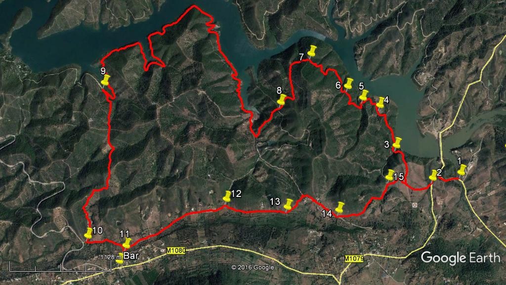
- Facing the farmhouse on the hill, (1) turn left and walk up the road. Ignore a turn to the left as it levels out, go through a short cutting and descend to another road at a T junction. Turn left and walk down for a short distance, to find a faintish track forking off to the right. (730m) (2)
- Drop down to cross a small stream and up, following the faint track as it curves around the hill to the right. Arriving at a more obvious dirt road with a ruin above on the hill, turn right. (340m) (Note: this is where you will meet the outward track on your return). Take the right fork uphill, leaving the ruin on your left, and go over the hill, straight across at a cross-tracks (230m) and down a more stony lane which you will see is heading straight for the barragem (reservoir). The track bears left and reaches the valley floor at a point where an arm of the barragem flows into it. (3) In wet conditions, the water level rises to fill this inlet, and you may have to go upstream a little in order to cross. (230m)
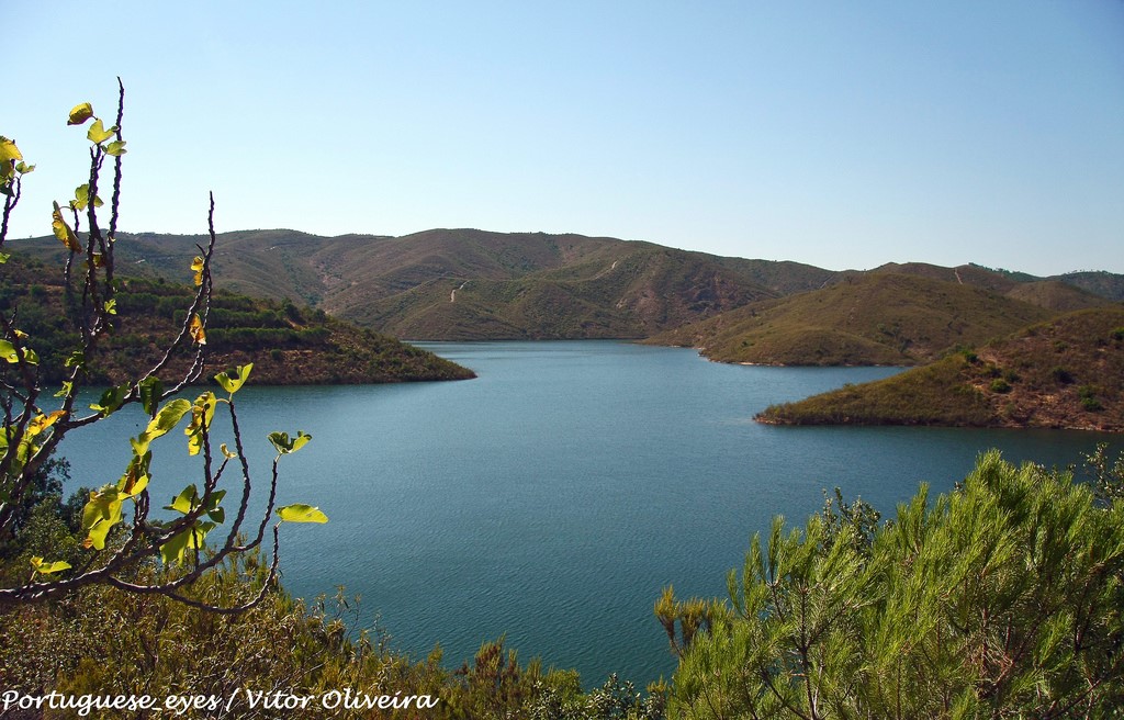
Barragem do Funcho.
- Once across, climb the short slope ahead to reach a much broader dirt road. Turn right. Follow this main track, ignoring any turns off, to pass a house on the right. (570m) (4) Soon after this the track begins to rise quite steeply. Ignore a track on the left going uphill (300m) (5). After a further rise and passing another steeply ascending path on the left (350m) (6), a gentle descent follows, making a long bend to the left, before another longer rise takes you to a saddle on a left hand bend after some distance.(790m) (7)
- Now the track undulates for a time heading southwest, before turning southeast and descending fairly gently, then a little more steeply to reach a junction of several paths (830m) (8) Take the second track on the right, which leaves the main track you have been following to descend quite steeply over stony ground to reach a junction with a much broader track at the valley floor, with an electricity pole on the right. (420m). (Note. Chains and private property notices have recently appeared on this section. Pedestrians can safely ignore them. They seem to be designed to deter motor traffic)
- Go round the hairpin to the right here and walk along the broad track, which soon leads to a further sighting of the barragem. The next section of the walk involves simply following the track as it winds for around 4.8k above the barragem, following the shape of the various inlets. Starting north- westerly, the line of the barragem turns south-westerly after a time, after which a very large, double-pronged inlet forces quite a detour (the shape is rather like the root of a molar). A further single-pronged inlet soon follows. Coming back to the main waterway from this second detour, find a track on the left turning back uphill in a hairpin turn. (9). Turn uphill here, heading east of south.
- After 480m arrive at a cross-tracks. Go straight across uphill, over and down into a valley, steeply at the end, followed by a steep rise to a hilltop where another track joins from the left. (500m) Stay right here and descend again steadily, heading more or less due south now, seeing the houses of Val Fuzeiros appear on a low ridge ahead. Pass a small barragem down to the left and come to a junction, with a tarmac road over to the right. (1k) (10) Turn left away from this road and follow the track along the valley floor until it rises to meet a tarmac road, with an industrial building on the right which is a warehouse collecting and distributing edible snails (caraçois). (11)(490m)
- This is the point where the extension track leads off. If you need refreshment, the bar restaurant O Gralha is very close by. Turn right, go to the bottom of the hill, turn right again and find it very soon on the right. (Note. It is perfectly possible to start the walk from O Gralha. The only route change needed is at point 15, where you need to turn left and follow the track downhill, to come to the side of the barragem close to point 3. Then continue ahead as per the notes. To get to O Gralha by car, use the N124 to GPS: 37// 14.59.11 8(( 18.50.89. Turn off left or right depending on direction of approach, to Amorosa. Drive through the village and follow signs to Val Fuzeiros. O Gralha is on the right, just over 2k from the final turn.)
- To continue with the main walk, turn left at the snail warehouse and follow the road as it runs more or less level and then rises gently to a crest, with scattered farms and houses on either side. It then descends to a junction in a valley. (1.24k) (12). Turn right here and walk east to pass a small group of houses on the left. Now see a track forking off on the right, ascending very gently, north of east (360m) Go along this, leaving more buildings over to the left beside the main track.
- Where this new track curves to the left (140m) go straight ahead on a fainter path, leaving a barragem on the left and passing close by a small building. Ascend slowly between bushes, pass a grove of trees on the left, and then bear left at a divide in the track (180m) (13) to continue the very gradual rise northeast to a broad dirt track with a large house with pool down to the right. (290m) Turn right and pass houses left and right. After the second group of houses on the right, come to a junction with a less obvious track forking off to the left, (450m) (14) with a broader one going back to the houses on the right. (This is where the extension track joins the main walk).
- Take this left fork and descend steadily to reach another junction with four possible exits. (750m) (15) (If starting from O Gralha, turn left here) Take the first right. The next junction, with a ruin up to the left, links you up with your outward track. Go right and then left on a faint track around the hill, cross the small stream up to the tarmac road (2) and turn left. Turn right and follow the road round and down to return to your starting point. (1k from point 15)
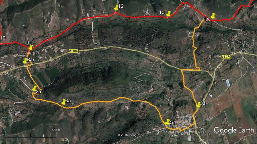
The Amorosa Extension.
- From Point 11, (the snail warehouse) turn right and descend to the main road. Turn right and walk along towards the bar-restaurant. Just before it, (by the parking area across the road) see a track going off on the left across the valley. (250m) (1a) Follow this down to a small stream, (often dry) cross over and walk through bushes to reach a wider track. Go straight ahead uphill to meet another track at a T junction and turn right. After a short distance arrive at another junction and turn left uphill (530m) (2a).
- If you wish to visit some of the prehistoric menhirs, turn right at the next track junction (480m) (3a) and follow the path up onto the ridge, walk along for a short distance to see the red sandstone pillars, with an information board (if it still stands). Retrace your steps to point 3a.
- Follow the track as it rises and falls, heading southeast and then due south, finally descending to the outskirts of the village of Amorosa, passing barragems, left and right on the way down the hill. (1.56k) (4a) Amorosa is a mass of small streets and squares. The best way through is to go straight across at the first crossroads and follow this road (Rua 18 de Janeiro) down to the Largo 25 Abril. Turn right on entering the largo, then left down the Rua Principal which brings you out onto the main road past the village. (430m) Turn left.
- Go round the bend with the house called Vila Nova on the right and then take the first track on the left (5a) by a small house with a garage next to the track. Fork left in front of the next big house, onto a grassy track, leading gently downhill northwest past a barragem on the left, and at the main road turn right. (780m) Turn left in front of the first house you see close to the road, (6a) and follow this narrow road quite steeply uphill until it ends at a small settlement with houses on either side. (770m) (7a) Go straight ahead to find a track leading quite steeply downhill towards a road in the valley. Bear right on a more obvious track where the incline begins to level out to reach the road. (340m) You are now at point 14 on the main route. Go straight across here to complete the walk.
Orientation normal GPS Points. (13//8) There are two images for this walk – one for the main walk and the second for the extension.
Main Track
| 1 | Start | 16 | 27 | 08 | 18 | 34 | 58 | |||
| 2 | Turn off tarmac | 16 | 21 | 56 | 18 | 45 | 63 | 400m | ||
| 3 | Crossing inlet | 16 | 27 | 68 | 19 | 06 | 28 | 800m | ||
| 4 | Lone house | 16 | 38 | 90 | 19 | 20 | 03 | 560m | ||
| 5 | Left trn 1 | 16 | 39 | 11 | 19 | 28 | 41 | 300m | ||
| 6 | Left turn 2 | 16 | 40 | 85 | 19 | 36 | 78 | 350m | ||
| 7 | Saddle | 16 | 46 | 66 | 19 | 57 | 45 | 730m | ||
| 8 | 5-way junction | 16 | 26 | 64 | 20 | 02 | 30 | 850m | ||
| 9 | Turn off barragem | 16 | 10 | 49 | 21 | 19 | 44 | 5.1k | ||
| 10 | Below Val Fuzeiros | 15 | 17 | 08 | 21 | 01 | 37 | 1.9k | ||
| 11 | Snail warehouse | 15 | 18 | 94 | 20 | 43 | 57 | 480m | ||
| 12 | Right in valley | 15 | 47 | 60 | 20 | 09 | 09 | 1.26k | ||
| 13 | Left fork over fields | 15 | 52 | 94 | 19 | 42 | 37 | 720m | ||
| 14 | Left at crossroads | 15 | 58 | 63 | 19 | 20 | 47 | 710m | ||
| 15 | Right at 5-way | 16 | 15 | 88 | 19 | 04 | 37 | 780m | ||
| End | 920m |
Amorosa Extension
| Point 11 to 1a | 260m | |||||||||
| 1a | Val Fuzeiros | 15 | 13 | 46 | 20 | 41 | 25 | |||
| 2a | Turn uphill | 15 | 03 | 13 | 20 | 34 | 27 | 510m | ||
| 3a | Menhir turn | 15 | 02 | 70 | 20 | 16 | 55 | 490m | ||
| 4a | Amorosa 1 | 15 | 10 | 79 | 19 | 22 | 61 | 1.52k | ||
| 5a | Amorosa 2 | 15 | 22 | 03 | 19 | 10 | 53 | 560m | ||
| 6a | Turn left | 15 | 37 | 48 | 19 | 16 | 31 | 800m | ||
| 7a | End of road | 15 | 51 | 02 | 19 | 27 | 09 | 560m | ||
| 7a to point 14 | 310m |