Walk 105. Ombria Circular. 13k. Ascent 480m.
GPS. 37/ 11.20.66 8/ 01.36.19
This is a relatively short walk, but it is not without challenges. It involves a tour through and around the recently (2024) opened Quinta da Ombria golf course, between Tor and Querenca, north of Loule. There is public access on the roads through the golf complex, after which a partly overgrown track climbs to the Loule - Barranco do Velho Road,and back down into the valley, passing a couple of fonts on the way. A walk along a quiet valley road leads to Val Mulher and thence out onto the open land parallel to the Loule - Salir road. Two possible endings are described, one descending back to the golf course, the other taking a route via Andrezes. There is a bar about 400m from the start of the walk, on the side of the Loule road as you approach the start.
Getting to the start.
The walk starts at the southern end of the Roman Bridge at Tor. From Loule, leave the northern bypass at the Rotunda de Salir and follow the road up through Cruz da Assumada and down the long hill towards Tor. The Bar Varzea is at the bottom of the three-lane section of the road, on the left. Continue across the valley floor. The Roman Bridge is on the left as the road bends right towards the river crossing and the traffic lights. You can park on the approach to the Roman bridge.
The Walk.
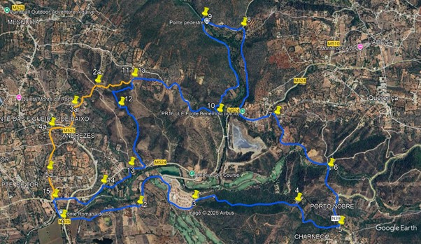
From your car, walk back to the junction with the main road and turn left onto it. (1) Walk for about 100m, then cross the road and take the lane leading off eastwards on the other side. Follow the lane. After 850m, stay left on the main track at a fork with a dirt track. (2) Follow the road as it curves right and arrives at the entrance to the golf complex after another 500m. Take the tarmac road as it climbe towards the buildings on the hill. Stay on the road as it swings round the cluster of blocks on the hilltop, and then straightens out (3) into more open country, with good views of the golf greens and the river down to the left.
The road runs out soon after this. At this point, turn right and scramble up the bank to locate a rather overgrown path heading uphill, and follow this carefully. The next junction is just over 900m along, at which point turn right. (4) You will have encountered an electric fence at the boundary of the golf estate. Simply unhook the wires at the gate and replace them after you go through. 200m after the junction, pass the rather neglected Fonte de Abelheira, and continue on to reach the Loule Barranco road after another 400m (5). Turn left and walk down the road for 350m, to arrive at a house on the left with a narrow lane leading off in front of it, signed to Fonte da Esparrela.
Turn along the lane and descend the steep hill down to the Fonte. Swing sharp left near the bottom and pass the Fonte on the left. (6) Cross the bridge ahead and turn left on the far side, passing the old mill house. Walk along the road through the valley for something over 900m, climbing out at the end, and staying left at a junction near the top (7). Now follow the road round a left hand curve into a dip, and out again to meet a main road after 150m. Turn left here and walk down for 330m, to see car park on the right, and the entrance to the Fonte de Benemola trail.
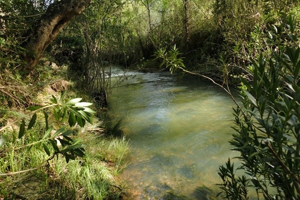
River at Fonte de Benemola
Turn right and follow the wide sandy trail for almost a kilometre. At a junction with a track coming in from the right, (8) turn left and continue to walk along the valley. After a further 470m, come to a picnic area near the Fonte, and see a narrow footbridge across the river on the left. (9). Cross here and turn left on the far side. Follow the rocky trail for 1.4k, turning right uphill at a junction (10). Now climb quite steeply, emerging from the trees onto open land. After 820m, take the left hand at a fork, and walk up for another 350m to find a turn onto a narrower track on the left by a small planted area. (11). Walk for just a few metres round the curve of the planted area, and take a very narrow path on the right. Follow this for 350 metres above a shallow valley, to come down to a small pond. Walk round this and take the track leading past the pond, heading south.
After 200m, turn left at a junction (12). Now follow this track as it winds steadily downhill for just over 800m, passing buildings at the end, to emerge onto a tarmac road, opposite the golf course you walked through earlier. Turn right here and walk for 120m. Find a narrow path on the left opposite a track on the right (13), and follow it for about 100m to a small building. Turn right here, and follow a wider track on level round for 350m, coming back to the tarmac. Immediately turn off left again, (14), to follow a track close to the river for another 400m. Come back to the road once more and turn left. You are now close to the traffic lights at Tor. Cross the main road with care, and walk along the road opposite for 250m. At the first crossroads (15) turn left, and walk along to cross the Roman Bridge back to your car.
GPS Points
| 1 | Roman Bridge, Tor. | 11 | 18 | 03 | 01 | 35 | 39 | |||
| 2 | Turn left | 11 | 23 | 60 | 01 | 02 | 30 | 880m | ||
| 3 | Turn right | 11 | 24 | 89 | 00 | 37 | 81 | 1.2k | ||
| 4 | Turn right | 11 | 22 | 06 | 59 | 53 | 41 | 1.2k | ||
| 5 | Turn left | 11 | 13 | 83 | 59 | 35 | 96 | 630m | ||
| 6 | Turn sharp left | 11 | 33 | 06 | 59 | 37 | 98 | 670m | ||
| 7 | Turn left main road | 11 | 45 | 59 | 59 | 53 | 60 | 950m | ||
| 8 | Turn Left | 12 | 23 | 68 | 00 | 12 | 24 | 1.4k | ||
| 9 | Bridge crossing | 12 | 16 | 32 | 00 | 13 | 36 | 450m | ||
| 10 | Turn right | 11 | 54 | 31 | 00 | 24 | 81 | 1.4k | ||
| 11 | Turn left | 12 | 08 | 00 | 01 | 00 | 99 | 1.2k | ||
| 12 | Turn left | 11 | 58 | 82 | 01 | 07 | 23 | 550m | ||
| 13 | Turn left | 11 | 37 | 48 | 01 | 04 | 88 | 1k | ||
| 14 | Turn left | 11 | 31 | 92 | 01 | 16 | 95 | 440m | ||
| 15 | Turn left | 11 | 29 | 98 | 01 | 19 | 80 | 650m | ||
| END | 300m |
Alternative Route from Point 11.
This alternative passes through rather more built-up terrain than the main route.
From Point 11 (1a), stay on the main track instead of turning left. Walk gently downhill for 430m to a crossroads. (2a). Turn left and continue downhill into a valley for 220m. Stay on the track as it rises again over the next 160m. At a junction (3a), turn left once more, and rise then descend over the next 250m, to emerge onto a main road. Turn right and walk up to the end of the crash barrier on the opposite side. Cross over and turn sharp left at the end of the barrier, to walk down over grass to a minor road. Turn right along it. Turn left with the road after 160m, (4a) and then descend quite steeply to a crossroads after another 190m. Cross over diagonally left and continue downhill on tarmac. Go straight on, passing a turn right after 300m (5a), and another to the left soon after. 200m on, come to a junction and turn right, soon coming down to a main road. This is Point 15 on the main route. Cross over into a narrow lane and walk the final 300m back to your car.
GPS Points.
| Point 11/1a | Straight on | 12 | 08 | 00 | 01 | 00 | 99 | |||
| 2a | Turn left | 12 | 06 | 77 | 01 | 16 | 54 | 430m | ||
| 3a | Turn left | 11 | 59 | 88 | 01 | 27 | 09 | 380m | ||
| 4a | Turn left | 11 | 52 | 89 | 01 | 57 | 38 | 450m | ||
| 5a | Straight on | 11 | 37 | 86 | 01 | 40 | 10 | 500m | ||
| END | 620m |