Walk x19. Parque da Mina Circular. 14.2k. Ascent: 600m
GPS: 37/ 15.15.21 8/ 32.21.92
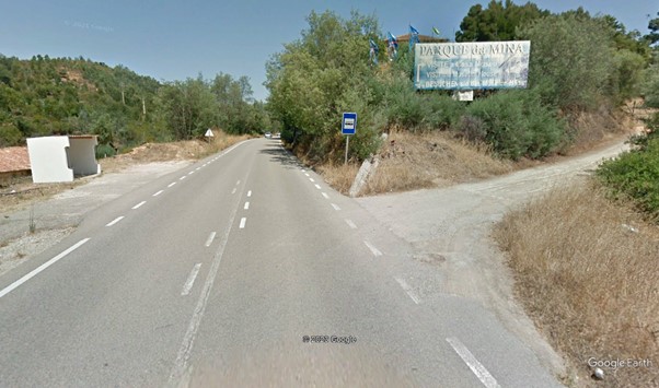
Parque da Mina is a visitor attraction situated off the main N266 road between Portimao and Monchique. The walk starts on a track alongside the site, and wanders up into the foothills of the Serra de Monchique. The terrain up here is a maze of tracks, through land which has suffered from fire in recent years, but is in recovery, with a lot of replanting in progress. Views of the Monchique summits are frequent, as is the vista down to the coast. There are no places of refreshment on the route, and you may have to pay entrance if you go to the Mina site, but there are cafes along the road before you reach the start-point.
The Start.
Getting to the Start.
Leave the A22 motorway at the Portimao exit, and follow signs to Monchique. (N266). Drive for just over 10k, staying in the Monchique direction after the roundabout at Porto de Lagos. Look for the advertising board for the Parque da Mina on the right. There is possible parking on the left, but best to have as few vehicles as you can manage if with a group.
The Walk
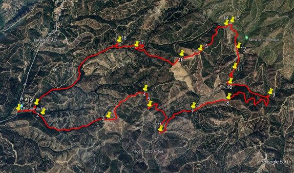
The walk starts on the track immediately right of the Parque signboard. (1) Walk along this track, on more or less level ground, for 320m, then turn right through a hairpin bend at a junction. Follow the track first south then east for another 260m, ascending gently, then stay right at a fork (2). Now follow the track as it ascends steadily (70 - 130m) over the next 1.3 k, heading first east, then northeast, in a valley. Arrive at a junction of tracks with five choices (3), and take the second from left, to continue climbing in a northeasterly direction.
Now on a ridge, carry on uphill for another 920m, swinging from northeast to northwest after 170m, then soon turning due north. Avoid dropping off the ridge, left or right. As the track turns to the northeast again at the end of this stretch, descend slighly, and stay right at a fork (4) (the left hand goes to a summit just ahead - you can do this and rejoin the route by turning right at the top). The main route continues, swinging southeast then south over the next 300m, still on a ridge line, rising a little, then starting to descend. Arrive at a fork looking south (5) and swing round 180 degrees to face north and continue to descend.
The track takes different directions over the next 800m, first heading north for 180, south then east fior another 340, and finally south again. The descent is quite steep until the final turn south, when the gradient eases. Arrive at junction in the valley and turn left (6). Pass a ruin on the right and after 100m turn left and left again to pass to the right of a property. Now walk steadily uphill in a valley for a further 660m, heading more or less due north. Arrive at a point where two tracks leave on the right very close to each other, and take the second one (7). This starts off northeast, but quickly swings northwards again, and continues to climb, on a ridge once more, with recently terraced and planted land on the left.
After 630m, come to a 3-way junction, and take the first left (8). The track rises a little more, then starts to descend, and continues to do so over the next 1.3k, with higher land on the right, and a valley on the left. The path meanders down into the valley and the slope becomes quite steep towards the bottom. Arrive at a junction and turn left through a hairpin bend (9). Walk straight ahead, west-southwest, in the valley for the next 760m, descending slowly. Find 2 tracks on the right, almost together, and take the second one, (10) a short, straight link heading northwest, and linking with a track (turn right onto it) which starts to climb steeply and winding.
The heading is generally north over the next 500m, but there are two or three hairpin bends. Pass a point (11), where a track on the left heads back south, and continue to climb more directly northwards for another 400m, leaving several south-heading tracks left and right. At a fork (12), take the left hand and continue to climb, now more northwesterly and less steeply, over another 550m, with higher land still on the left. Come to a junction (13) with a house over on the left, and a small barragem or dam in the valley beyond it. Swing round to the left and start to descend very gently. Heading more or less soiuth now, walk overlooking the barragem, and at a 3-way junction (14), take the middle option, staying right at another fork almost immediately afterwards.
The track now heads more or less due south, climbing to reach a summit after 350m, and then descending on a ridge for a further 400m. Arrive at an open space (15), with various tracks leading off, and follow the right-hand one, south, then southeast, for 350m, descending, staying right at a fork after 120m. Come to a 3-way junction (16), and take the middle option, heading due south, on more or less level ground. After 180m, turn right, following this forest track down into a valley, with terraces or recent planting on either side.
After 620m, turn left at a junction, and follow the track round a right-hand curve, staying right at a fork after less than 100m. Come to a junction and turn sharply right (17), and almost immediately take the left at a fork, heading northeast then north. After 140m, turn through a hairpin bend onto a track heading first south but soon southwest, through recently planted trees. Walk above the valley for 500m, when the track turns briefly north, to join a wider track at a junction. Turn sharp left here (18), and follow this track as it descends. After 400m, it joins a track on the valley floor, and continues south. Follow the track down the valley for 1.6k, to a junction. (19). This is near the start of the walk, so take the right-hand option to walk the remaining few metres back to your car.

The Main House at Parque da Mina.
GPS Points. (37/8)
| 1 | N266 | 15 | 15 | 21 | 32 | 21 | 92 | |||
| 2 | Stay right | 15 | 22 | 41 | 32 | 07 | 28 | 600m | ||
| 3 | 2nd from left | 51 | 44 | 28 | 31 | 26 | 63 | 1.27k | ||
| 4 | Fork right | 16 | 07 | 94 | 31 | 25 | 71 | 920m | ||
| 5 | Hairpin left | 16 | 03 | 00 | 31 | 16 | 45 | 310m | ||
| 6 | Turn left | 15 | 57 | 26 | 31 | 00 | 34 | 820m | ||
| 7 | 2nd right | 16 | 18 | 14 | 30 | 53 | 66 | 760m | ||
| 8 | First left | 16 | 33 | 57 | 30 | 40 | 05 | 630m | ||
| 9 | Hairpin left | 16 | 51 | 11 | 30 | 20 | 51 | 1.3k | ||
| 10 | 2nd right | 16 | 42 | 01 | 30 | 45 | 37 | 760m | ||
| 11 | Straight on | 16 | 49 | 56 | 30 | 48 | 68 | 510m | ||
| 12 | Fork left | 16 | 59 | 80 | 30 | 56 | 84 | 400m | ||
| 13 | Turn left | 17 | 09 | 25 | 31 | 11 | 86 | 580m | ||
| 14 | Middle of 3 | 17 | 05 | 65 | 31 | 13 | 69 | 120m | ||
| 15 | Right hand track | 16 | 44 | 46 | 31 | 15 | 60 | 760m | ||
| 16 | Middle of 3 | 16 | 35 | 49 | 31 | 22 | 80 | 350m | ||
| 17 | Sharp right | 16 | 23 | 93 | 31 | 51 | 72 | 1k | ||
| 18 | Sharp left | 16 | 19 | 49 | 32 | 03 | 04 | 780m | ||
| 19 | Turn right | 15 | 23 | 79 | 32 | 15 | 48 | 2k | ||
| END | 330m |
North is on the right.