
Walk X18. Val D`Agua Circular. 16.2 kilometres. Ascent: 825m.
GPS: 37/ 15. 11. 63 8/ 39. 12. 82
This walk takes in some of the wild country north of the small settlement of Mexiloheira Grande, beyond the Portimao motor racing curcuit. There is a fair amount of habitation here, scattered in the valleys leading up to the Monchique summits here, and views up to the Monchique summits are a real reward for what is quite a challenging route, reaching up to the Monchique - Marmalete Road. As the route is a figure of eight, it is possible to do either half, but if doing the northern half, one must start at point 11. The southern half is by far the more difficult, involving c500m of climb. There is a short extension which lengthens the northern half by c.1.2k.
Getting to the start.
There is no settlement at the start of this walk, and refreshment must be had in Mexiloheira Grande before and afterwards. There is a restaurant/snack bar on the Monchique road, just after Point 11, and a further one before Point 12. Leave the A22 motorway at the Mexiloheira/Autodromo exit, and follow signs to the latter. Approaching the racing circuit, go through two roundabouts, staying on the dual carriageway, and passing under the welcome gantry. At the third roundabout turn left onto a single carriageway road, and drive for 2.6k to arrive at a fork, with the right hand signed to Picotas. Park here where you can.
The Walk.
From the fork in the road where you have parked, (1) take the right hand, signed to Picotas, and walk for 700m, rising gently. At a fork, take the left-hand, and at a further fork after 170m, take the right hand. (2). Follow this track as it climbs steadily for 1.6k. Go straight on at a 90 degree junction with a narrow track on the right, (3) and continue to climb. Follow round a right hand U-turn after 730m, then go through a hairpin left after another 130m. Continue upwards for a further 540m, then descend slowly for a further 360m to arrive at a junction of various tracks, with a house ahead. (4). Follow the main track as it curves left, leaving the house on the right. Walk for 500m, climbing a little at first, then undulating and finally dropping slightly to a junction (5). Here there is a small settlement, with a house on the left and another over to the right ahead.
Turn left after the first house, and immediately left again in front of a small outhouse. Stay left at a fork after the first bend, and right at another fork after a further 150m. Continue to descend steadily over another 320m, and stay right at a fork (6) before going through a sharp right hand curve. Descend to the valley (small building down on the left), and cross at the depression, taking the right hand at a fork, and immediately starting to climb. Ascend steeply for 320, going through sharp right and left hand bends, to reach a junction overlooking a valley with a barragem and farm (further buildings visible up the valley). (7).
Turn right here, and walk northeasterly for 300m, half of it gently downhill, the rest steadily up. Stay left at a track junction (8), and continue to climb for 400m, then swing left with the path and descend a little to a large shed on the left. (9). Here the track widens to a dirt road, and continues, trending due north on a winding course for 240m, passing a farm on the way. Reach a junction with a track on the right, (10) and stay left, continuing to head due north. Avoid all turns left and right, as you continue to climb slowly and the track turns more to the northeast. After 730m, arrive at a main road with houses and terracing down to the left. (11). This is the main road between Monchique and Marmalete. Turn right.
You must now walk along the road for 1.8k. Thankfully it is not too busy, but care is needed. Pass one restaurant/snack bar after 650m, and another at the 1.4k mark. 370m after this second place of refreshment, turn right on a tarmac surface, just before a set of buildings on both sides of the main road. (12). After descending steadily for just under 600m, turn 90 degrees left with the tarmac, and after a short distance take the right at a fork. (13). Descend south for 400m to arrive at a small outbuilding, with a larger building over to the right. (This marks the start of the short extension route - see below) Turn left here and drop down on a rough path to a tarmac road, at the side of a house. Turn right (14)
Walk for 600m, arriving at a junction with a track on the right. You are now back at Point 5 (15). Go straight on, past the house on the left, and descend very slowly along your outward track for c530m, arriving at a junction with a house on the left. This is Point 4 (16). The next stretch covers 2.8k, always heading downhill. Take the bend to the right, and at the fork on the crown, take the right hand. Head northwest for a short time, then turn southwest, and continue on this line, avoiding all turns right and left away from it. The track eventually turns due south, and soon after the surface becomes more like a road, and comes to a junction with houses left and right. This is Corte Cibrao - see the wooden sign. (17).
Go straight across here onto a very faint grassy track between orchard trees and bushes, heading southeast, turning due south and becoming a dirt track. Stay left after 200m and work round to the left, passing two buildings on the left, and arriving at a junction facing a barragem (reservoir). (18) Turn left. Walk along the side of the barragem, taking the right hand at a fork at the end, then walk 430m southeast to a junction. (19). Turn right. Walk 230m to another junction. This is Point 2. Turn right and walk back the remaining 900m to the start of the walk and your car.
Extension.
The 1.2k extension starts just short of Point 14, as indicated in the text above. (1a) Instead of turning left down to the tarmac, continue right in front of several buildings, and follow the track beyond them. After 430m, fork left at a junction, and shortly afterwards stay left at another one. After 250m, turn 90 degrees at another junction and walk due south for 270m. Here the track turns due east, and joins the main route shortly afterwards. (2a) Turn right, to rejoin.
GPS Points.
| 1 | Fork right | 15 | 11 | 63 | 39 | 12 | 82 | |||
| 2 | Fork right | 15 | 35 | 33 | 38 | 52 | 50 | 900m | ||
| 3. | Straight | 16 | 18 | 96 | 38 | 38 | 70 | 1.6k | ||
| 4 | Straight | 16 | 59 | 07 | 38 | 20 | 63 | 1.75k | ||
| 5 | Turn left | 17 | 13 | 22 | 38 | 21 | 66 | 540m | ||
| 6 | Stay right | 17 | 04 | 38 | 38 | 35 | 59 | 560m | ||
| 7 | Turn right | 17 | 12 | 85 | 38 | 45 | 18 | 510m | ||
| 8 | Stay left | 17 | 21 | 44 | 38 | 39 | 01 | 300m | ||
| 9 | Turn right | 17 | 30 | 23 | 38 | 47 | 10 | 500m | ||
| 10 | Bear left | 17 | 35 | 96 | 38 | 50 | 03 | 230m | ||
| 11 | Turn right | 17 | 56 | 32 | 38 | 36 | 80 |
750m |
||
| 12 | Turn Right | 17 | 43 | 57 | 37 | 47 | 75 | 1.8k | ||
| 13 | Fork right | 17 | 36 | 97 | 38 | 07 | 04 | 600m | ||
| 14 | Tun right | 17 | 25 | 10 | 38 | 09 | 46 | 440m | ||
| 15 | Straight | 17 | 13 | 22 | 38 | 21 | 66 | 600m | ||
| 16 | Curve right | 16 | 59 | 07 | 38 | 20 | 63 | 540m | ||
| 17 | Fork left | 15 | 57 | 66 | 39 | 27 | 17 | 2.8k | ||
| 18 | Turn left | 15 | 51 | 66 | 39 | 16 | 73 | 450m | ||
| 19 | Turn right | 15 | 42 | 74 | 39 | 56 | 82 | 600m | ||
| End | 900m | |||||||||
| Ext 1a | Turn right off main | 17 | 26 | 16 | 38 | 11 | 41 | |||
| ext 2a | Turn right onto main | 17 | 20 | 86 | 38 | 19 | 64 | 1.2k |
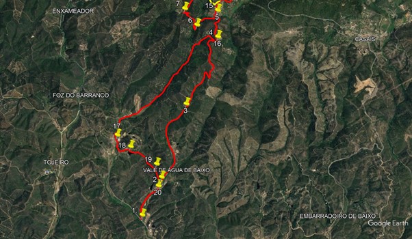
Southern loop.
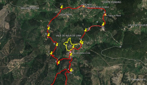
Northern loop with extension.