
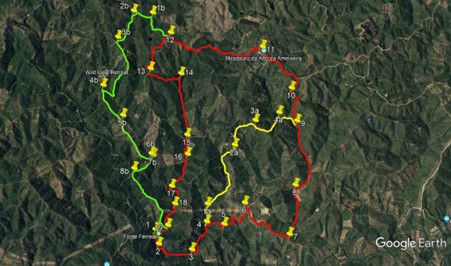
Walk x17. Fonte Ferrea - Miradouro do Alte de Ameixeira Circular.
3 Options: 14.4k, 13.6k, 16.2k. Total ascent around 600m
Fonte Ferrea is a popular picnic spot off the EN2 road north of the village of Alportel. It is the start point for a number of walks too. The nearest large town is Sao Bras de Alportel, about 4k to the south. The walk leads from the valley at the fonte steeply up to one of the most spectacular viewing points in this part of the region, where you may picnic at tables and enjoy the vista. There is a cafe at the fonte, but it may not be open in the early morning.
Getting to Fonte Ferrea.
Leave the A22 motorway at the Faro/Sao Bras de Alportel exit, and travel north towards Sao Bras. At a roundabout immediately after a filling station, go straight across. This is the Sao Bras bypass. At the next roundabout go straight across, and at the following one turn right, signed to Almodovar and Alportel. Turn left the next roundabout, signed to the same two places, and follow this road for 3.2 k, passing through the village of Alportel. The road rises after the village, and as it bears left after a few hundred metres, see a wooden construction like the entrance to a Texan ranch over on the right, with ´Fonte Ferrea´on a sign below the crosspiece. Turn to this and follow the road down to the fonte, parking in the obvious area.
The Walk.
Main Route.
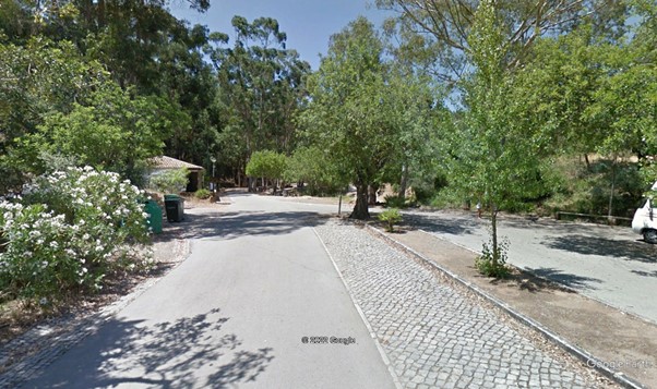
Fonte Ferrea.
From the cafe (1) turn right and walk back along the road for 250m.. Find a track leading off on the left (2) and follow it for around 100m through trees to reach a junction with another track. Turn right and walk gently downhill, rounding a left hand curve, for 500m, to a small open space.(3). Bear left here and walk around a wide right hand curve for 140m, then turn left on a track heading due north in a valley. Climb gently for 500m to a fork (4). Take the right hand and climb more steeply for 250m, turning right at a junction to descend for 120m. Turn sharp (5) left onto a track which descends in a winding fashion to a valley floor. Cross over a minor track at the bottom and then climb steeply up to a tarmac road. (6)
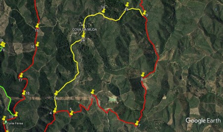
At the road turn right and walk down for 400m, then turn sharp left on a track. After a short distance see a barragem ahead in a valley, then follow the track round to the right. 400m from the road cross over a track and come to a second cross-tracks after another 200m. (7). Turn left and drop down quite steeply for 280m into a valley. Cross over a track at the bottom, and climb much more gently for another 580m. At a fork (8) take the right hand track, and after 450m stay left at a junction. Bear round to the left and stay left again at a second fork. Walk almost due north for just over 800m, climbing steadily. At yet another fork,(9) take the right hand, and continue broadly north for a further 500m, aascending more steeply.
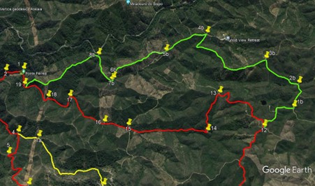
Pass a ruin over to the right, and come to a small open space.. Bear left through it, and very shortly turn 90 degrees left to walk first west and then northwest over the next 170m, climbing gently. Come to a cross-tracks and turn right (10). Continue to climb steadily for 220m, bear left at a junction, and after 100m more of climb come to a much wider dirt road, and turn left. Walk for almost 800m, broadly northwest, to reach the Miradouro, with picnic tables, where you may sit, eat and enjoy the magnificent view. (11). Hopefully refreshed, turn left from the picnic area, and descend to a tarmac road. Cross over, bearing left into a broad track heading generally west, and follow it for 1.2k. At a fork with a track heading south, stay right and walk along the broad track for a further 570m, to arrive at a three-way junction. (12). Take the left hand option, which continues roughly west for around 100m, then dips south.
After another 140m, turn right on a track which avoids the summit of the climb. (You can go straight ahead to the ruined windmill on the top if you wish, then turn right to descend and join the route at a cross-tracks, but the descent is steep.) Come to a cross tracks after 220m, and go straight across.. Now descending quite steeply and heading due south, walk for 240m, then turn west with the track and walk round a wide bend for the next 230m, arriving at a junction. (13). Turn left and walk on much more level ground for another 560m, heading roughly east. Drop down to a junction (14) and turn right. Descend south in a valley for the next 1.1k, coming to a junction with a track running east-west. (15). Turn left, and after a short distance turn right on a narrower track to continue heading south.
After 200m, the track starts to turn right in a sharp bend. Pass one track on the left heading south, then take a second , narrower one, almost at the apex of the bend, again going south through trees. After 100m, it emerges in open country, and heads south for a further 100m to meet another track at a cross-tracks.(16). Go straight across and follow a narrow footpath on fairly level ground for 330m, just west of south. Cross a track heading southeast as your track turns southwest and continues for another 320m.Come to a point where three tracks converge (17), and go straight ahead as the single track heads first eastwards and then turns south again. After 450m see a track coming to join from the left, (18)and continue across an open, probably ploughed, area and back into scrub for another 460m. Stay right at a junction (19), and walk the final 230m back to the Fonte,crossing the river either on the stepping stones if there is water, or by walking across the bed,
Alternative A.
Follow the Main Route to Point (4). At the fork, take the left hand track and climb gently for 300m, due north. At a fork (1a) tale the right hand and walk for 1.3k, northeast then north, then northeast again. The last short section is steep. Emerge onto a tarmac road in the settlement of Cova da Muda (2a) and turn left.. Walk for 670m to a point where the road bends to the left, with a junction on the right and a small group of houses. (3a) Turn right here and walk along a track for 240m. Now find a faint track heading off on the left, and walk along it for a few metres to join a wider footpath which curves left to head due north for around 350m.. Come to a junction with a track running east-west (4a) and turn right. Walk for 370m to another track junction. This is Point 9 on the main route, so turn left and use the instructions for the main route from here.
Alternative B.
Follow the main route to Point 12. At the fork take the right hand, and walk for 560m, roughly west, on fairly level ground at first, then descending quite steeply.Avoid taking either of two turns to the left. Come to a T junction (1b) and turn left. Stay left at a junction after almost 200m, and after 350m turn left at a fork (2b). Walk due south and after a short time start to climb quite steeply on s ridge. After 570m, come to a junction and turn left (3b). Walk first southeast, then due south, for just over 1k, descending quite steeply. Turn sharp right with the track and after another 200m, rise to a junction (4b).
Make a hairpin turn to the left to walk southeast for a further 630m.. At a fork turn right. Stay left at twp forks over the next 200m, and walk down the ridge for another 880m. Come to a junction and turn right. Walk through two short bends and at a junction afteer the second one stay right to walk southwesterly.(7b) Climb on a ridge. Stay left after 130m, and turn away from a summit but continue to climb, reaching a summit after 400m, overlooking a tarmac road.(8b). Trun left, away from the road, and continue to descend south for a further 1.2k.. Come to a junction and turn right. After a few metres arrive at a fork. This is Point 19 on the main route, so simply follow round to the right to the end of the walk.
GPS Points (37/7).
| 1 | Fonte Ferrea | 11 | 06 | 41 | 54 | 51 | 45 | |||
| 2 | Left off road | 10 | 59 | 94 | 54 | 49 | 37 | 200m | ||
| 3 | Turn left | 10 | 55 | 25 | 54 | 27 | 62 | 650m | ||
| 4 | Fork right | 11 | 09 | 56 | 54 | 17 | 22 | 650m | ||
| 5 | Sharo left | 11 | 08 | 10 | 54 | 05 | 61 | 360m | ||
| 6 | Turn right | 11 | 18 | 73 | 53 | 51 | 49 | 770m | ||
| 7 | Turn left | 11 | 01 | 40 | 53 | 22 | 67 | 1k | ||
| 8 | Fork right | 11 | 26 | 88 | 53 | 16 | 75 | 900m | ||
| 9 | Fork right | 12 | 01 | 41 | 53 | 13 | 59 | 1.3k | ||
| 10 | Fork right | 12 | 18 | 80 | 53 | 16 | 91 | 720m | ||
| 11 | Miradouro | 12 | 41 | 54 | 53 | 35 | 44 | 1.1k | ||
| 12 | Fork left | 12 | 50 | 89 | 54 | 37 | 01 | 1.8k | ||
| 13 | Fork left | 12 | 32 | 17 | 54 | 51 | 60 | 950m | ||
| 14 | Swing right | 12 | 28 | 89 | 54 | 31 | 27 | 580m | ||
| 15 | Stay right | 112 | 01 | 07 | 54 | 26 | 51 | 900m | ||
| 16 | Across | 11 | 45 | 52 | 54 | 28 | 60 | 570m | ||
| 17 | Turn right | 11 | 28 | 92 | 54 | 39 | 78 | 660m | ||
| 18 | Stay right | 11 | 19 | 54 | 54 | 38 | 00 | 420m | ||
| 19 | Stay left | 11 | 09 | 21 | 54 | 42 | 38 | 430m | ||
| End | 260m | |||||||||
| ALT A | ||||||||||
| 4-1a | Fork right | 11 | 18 | 82 | 54 | 16 | 17 | 300m | ||
| 2a | Turn left | 11 | 49 | 43 | 53 | 56 | 62 | 1.3k | ||
| 3a | Stay right | 12 | 02 | 16 | 53 | 42 | 20 | 670m | ||
| 4a | 2nd right | 12 | 06 | 36 | 53 | 25 | 57 | 590m | ||
| ALT B | ||||||||||
| 12-1b | Turn left | 13 | 02 | 89 | 54 | 49 | 19 | 570m | ||
| 2b | Fork left | 13 | 04 | 02 | 55 | 01 | 86 | 350m | ||
| 3b | Turn left | 12 | 49 | 24 | 55 | 12 | 37 | 580m | ||
| 4b | Sharp left | 12 | 24 | 36 | 55 | 24 | 31 | 1.3k | ||
| 5b | Fork right | 12 | 07 | 52 | 55 | 11 | 20 | 630m | ||
| 6b | Turn right | 11 | 47 | 45 | 54 | 53 | 20 | 880m | ||
| 7b | Turn right | 11 | 45 | 78 | 54 | 51 | 74 | 100m | ||
| 8b | Turn left | 11 | 38 | 96 | 55 | 04 | 10 | 390m | ||
| END via 19 | 1.45k |
Main Route
Alt A
Alt B Left is south.