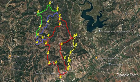
Walk Fifty Four. Three Options from Pinheiro - Garrado.
1) 12k 650m of ascent. 2. 14.5k 750m 3) 15.5k 850m.
The twin hamlets of Pinheiro and Garrado lie about 2.5k east of Silves, just off the main EN124 road from Silves to Messines. Three walks of varying lengths can be taken from Cafe Elias on the edge of the settlement. The hills on the northern flank of the Arade valley are not the easiest in the Algarve, as they tend to involve a lot of repeated ascent and descent, but the views are good, and none of the drops and climbs are too long. So, we have three routes, and the main route has an alternative start which adds no more distance, but 100m of additional climb.
Getting to Cafe Elias.
From Silves (west), drive out along the N124 for 2.5k. Pass a small cafe/restaurant (Taberna da Norinha) on the left, and take the next left (unsigned). The Cafe Elias is about 130m along on the left. From the east, follow the 124 from Messines. After crossing the long bridge over the Rio Arade, 11k from Messines, take the third tarmac road on the right, opposite a very large abandoned industrial building, and find the cafe just up the road.
Please try to park away from the cafe car park, as it may be needed by other customers at lunchtime.
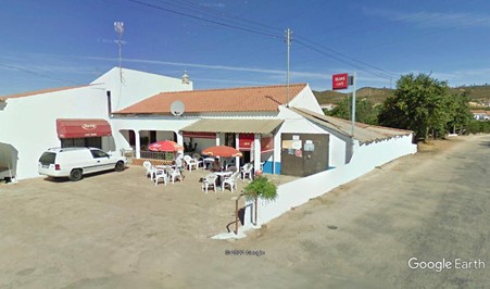
Cafe Elias
The Walks. Main Route. 12k (Red line)
With your back to the cafe, (1) turn left and walk for 250m to a junction. Turn right and walk along the tarmac road for 550m. At a point where the road curves right, back towards the main road (house on the corner with a well in the garden), bear left onto a dirt track (2). Follow it round to the left to arrive at a levada (irrigation channel), and walk alongside it for a few metres before crossing it and turning left. Walk by the levada round the next bend with a farm on the right, and at the next bend turn away from the water on a narrow footpath leading uphill northwards. After 100m, emerge onto a much wider dirt track by some small buildings, and bear right up it. Go straight on at a cross-tracks after 150m, and continue north for a further 400m, climbing steadily.
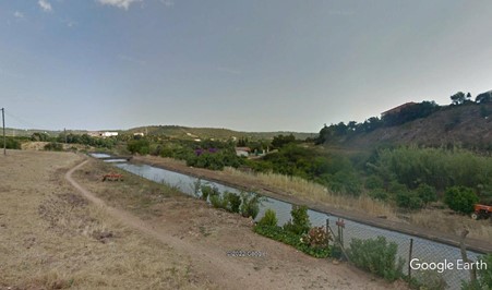
Levada Crossing
At a point where the wide track turns 90 degrees left, (3 take a narrower path just to the right of it, heading steeply uphill. After 100m, bear right with the track, and continue northwards on a ridge, continuing to climb at varying inclines. Reach a high point after something over 900m (4). The direct route is to veer left here, and descend very steeply for a short distance to a junction. If this is too steep, turn right and go down a bit more gently for just over 100m to a cross-tracks. Turn left and contour round the hill for 230m to a junction, and turn right. From here, in either case, head down northwards for a short distance to another junction, and turn right.
Now in a valley, starting off due east, the track tends more northeasterly as you cover the next 1k, descending gently the whole time. Arrive at a point (5), where a wide track comes in from the left downhill, and take this by turning very sharp left. Now start to climb again, heading west of north. Climb for 560m, then descend for about 380m, and finally climb fairly gently once more over 900m, to reach a high point on a left-hand curve. Drop down briefly to a cross-tracks (6), go straight across and head due south for just over 200m to come to a junction of several tracks. (7) . Of three tracks heading southwards from here, take the right-hand one, and climb for about 100m, at which point it turns 90 degrees. Follow the track over more or less level ground, as it moves from south-east to due south over the next 300m. Now it turns right. Almost immediately, see a track on the left heading south (8) and descend on it for a short distance to another junction, where turn right..
Head west and then curve round to due south, staying left after 290m. On a ridge now, the track heads down for another 260m before turning west briefly and then resuming the south/southwesterly trend. After another 420m, pass two tracks close together heading due south, turn due west with the track and climb to a junction after 160m. (9). Turn sharp left here and resume a southerly direction. After 150m, take the left hand at a fork, and descend quite quickly on a ridge for the next 440m, to arrive at a junction in the valley. (10). Turn left and walk gently uphill in the valley for almost 400m, coming to a cross-tracks and turning right. Walk due south for 600m, taking the right hand at a fork after 250m.
At (11), take the left hand at the fork, and continue south, downhill, for a further 700m. Near the low point, stay left at a fork, (12) and almost immediately turn left on a short track that bends to the right and brings you to a wider track at a T junction. Turn left and climb again for 300m, after which the track curves round to head south, reaching a junction after another 190m. Dog-leg left and right to continue southwards for a short time before turning east to come to a multiple junction.(13) Take the third on the right and walk south-east for 200m, then take a track on the right to descend south for the next 700m. Reaching a tarmac road, cross the levada, turning left, and then take the first on the right to walk the 300m back to the cafe.
Alternative route from Point 2 to Point 5. (Yellow line)
From Point 2, follow the main route, but then turn right in front of the first set of buildings, along a poorly maintained tarmac surface. (1a). Follow the track round to the left as it climbs to pass between a second set of houses, then swings round right to arrive at junction with a third group of buildings on the left and a barragem ahead across the road.. Turn sharp left and climb on a well, surfaced track for around 300m. Seeing a house ahead, turn left on a narrow track (2a) which curves round to the left to meet another track after 130m. Turn right and walk for 150m north-east. Here the track turns north and becomes a narrow footpath for about 100m before widening out again.
300m from this point, pass two tracks, one left and one right, heading back south. Very soon after this come to a fork and take the right hand (3a).Now head north, north-east and north again over the next 500m, ignoring a turn to the right after 130m., and climbing all the time. At the high point (4a), turn through 90 degrees left with the main track, and after 130m turn right, heading due north again, downhill. After just over 500m, the main track hairpins left. Go straight on from here on a less obvious track, and after around 120m, arrive at a junction with a track in the valley. (5a). Turn left and after 150m arrive at a fork. This is Point 5 on the main route, so take the right-hand to continue the walk, using the instructions above from this point.
North Extension 1. (Blue line)
From point 6 on the main route, turn right, descending and at a fork after 230m, take the left hand. Continue to descend, and after another 200m, turn sharp left (1b). Now walk along a valley, descending very gently, on a winding track. After 1.5k, see a wide track on the left, heading back uphill (2b), and continue on the same track. After another 450m, join another track from the left by a small building, and continue straight ahead. After another 900m, come to a fork, and take the left hand (this is where the 2nd northerly extension joins in.) (3b)
The track winds south for around 750m. Come to a three-way split in the track (4b) and take the left hand, which soon curves round to the left. Heading due east in the valley from here will get you on an easy path to Point 10 on the main route, but to continue on a harder path, turn left uphill from the crown of the curve. climbing quite steeply for just over 400m. At a junction turn left and climb again for 180m, turning sharp right here to drop down for a time before climbing again to a junction after another 320m. This the main route, so turning right will get you to Point 10 after 430m, from where you can complete the walk.
North Extension 2. (Green line).
From Point 1b, walk due north for 100m, then turn left and climb steeply for 330m, followed by an undulating track for the next 420m, ending at a junction. (2c) Turn left and after 190m stay right at a fork. Walk again on an undulating course, southwestwards, for another 850m to reach another junction. (3c) Turn left, ignore a track on the right after a short distance, and turn right with the main track after 300m. Now follow the track due south over a high point, and along a ridge, ignoring various turns left and right.. Come to a fork after 850m and take the right hand. (4c). After 200m take the left at another fork, and continue south for a further 440m, rounding a sharp bend by a ruin at the end, to reach a junction. This is Point 3b. Turn right to follow instructions for North extension 1 from this point.
GPS Points. (37/8)
| 1 | Cafe Elias | 12 | 42 | 79 | 24 | 03 | 38 | |||
| 2 | Bear Left | 12 | 51 | 94 | 23 | 56 | 70 | 800m | ||
| 3 | Turn left | 13 | 16 | 09 | 24 | 05 | 29 | 890m | ||
| 4 | Turn left | 13 | 44 | 19 | 24 | 13 | 18 | 1k | ||
| 5 | Sharp left | 14 | 01 | 86 | 23 | 40 | 72 | 1.2k | ||
| 6 | Straight across | 14 | 44 | 12 | 24 | 18 | 57 | 1.8k | ||
| 7 | Fork right | 14 | 37 | 36 | 24 | 18 | 79 | 210m | ||
| 8 | Turn left | 14 | 26 | 04 | 24 | 18 | 05 | 420m | ||
| 9 | Sharp left | 14 | 02 | 32 | 24 | 47 | 66 | 1.3k | ||
| 10 | Turn left | 13 | 46 | 31 | 24 | 54 | 72 | 600m | ||
| 11 | Turn left | 13 | 26 | 11 | 24 | 48 | 61 | 1k | ||
| 12 | Left, right, left | 13 | 05 | 33 | 24 | 45 | 87 | 680m | ||
| 13 | 3rd right | 13 | 06 | 15 | 24 | 27 | 34 | 680m | ||
| END | 1.2k | |||||||||
| Alt start. Cafe | 12 | 42 | 79 | 24 | 03 | 38 | ||||
| 1a | Turn right | 12 | 55 | 07 | 23 | 57 | 30 | 900m | ||
| 2a | Fork left | 13 | 10 | 30 | 23 | 52 | 43 | 740m | ||
| 3a | Bear right | 13 | 27 | 66 | 23 | 50 | 11 | 700m | ||
| 4a | Fork left | 13 | 42 | 70 | 23 | 36 | 66 | 620m | ||
| 5a | Turn left | 14 | 03 | 28 | 23 | 35 | 37 | 840m | ||
| 5 | Fork right | 14 | 01 | 86 | 23 | 40 | 72 | 160m | ||
| Ext 1 (6) | Turn right | 14 | 44 | 12 | 24 | 18 | 57 | |||
| 1b | Sharp left | 14 | 56 | 42 | 24 | 24 | 48 | 440m | ||
| 2b | Stay right | 14 | 32 | 45 | 24 | 49 | 59 | 1.5k | ||
| 3b | Stay left | 14 | 04 | 57 | 25 | 15 | 74 | 1.2k | ||
| 4b | 1st left | 13 | 48 | 19 | 25 | 18 | 09 | 800 | ||
| 5b | Sharp right | 13 | 58 | 04 | 25 | 02 | 96 | 670m | ||
| 10 | Turn left | 13 | 46 | 31 | 24 | 54 | 72 | 800m | ||
| Ext 2 (1b) | Straight on | 14 | 56 | 42 | 24 | 24 | 48 | |||
| 1c | Turn left | 14 | 59 | 38 | 24 | 24 | 91 | 100m | ||
| 2c | Turn left | 15 | 10 | 91 | 24 | 44 | 57 | 720m | ||
| 3c | Turn left | 14 | 52 | 58 | 25 | 15 | 67 | 1.1k | ||
| 4c | Straight across | 14 | 21 | 73 | 25 | 05 | 24 | 1.2k | ||
| 3b | Turn right | 14 | 04 | 57 | 25 | 15 | 74 | 700m |