Walk Twenty Three. Barragem do Arade Circular. ;17.2K ;Ascent: 604 metres
GPS: 37/ 14 00 43 8/ 22 47 16
I am indebted to Geoff Hill for exploring and leading on this route.
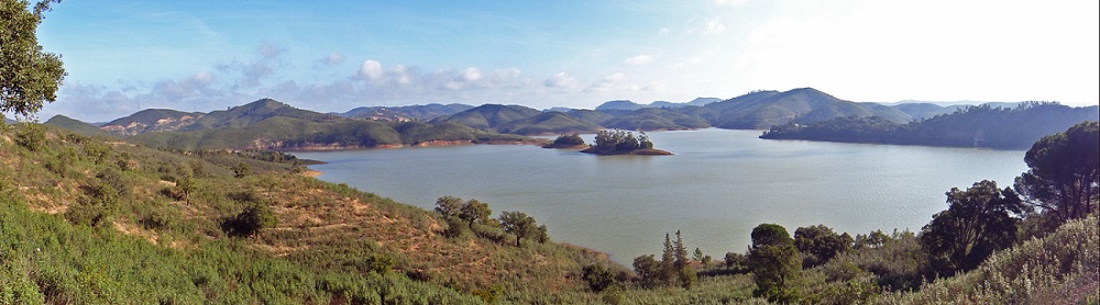
A walk around one of the large reservoirs (barragems in Portuguese) serving the Algarve. This one is mainly used for agricultural purposes, supplying a large canal or levada which is used to irrigate orchards and vineyards along the Arade valley. The levada itself has a footpath alongside which can be walked all the way to Silves and beyond. This walk starts from below the dam up to a high ridge overlooking it. It then drops to cross the Arade stream under the dam wall of a larger and more recent barragem, the Barragem do Funcho. Rising again, the circuit is continued, and we are soon looking down on a remarkable environmental project aimed at re-introducing the Iberian Lynx into Portugal. From a viewpoint on the hilltop, one can see into the breeding centre, and occasionally catch sight of one or more animals. The walk then drops again to pass below the lynx enclosure, and winds its way back to the dam wall, crossing it and descending back to the start. There is a small bar at the start, but no other refreshments on the route.
Getting to the start.
From the west, travel to Silves (from the A22 Silves/Lagoa exit, or the N125 at Lagoa) and pick up the N124 by crossing the river into the town. Turn right along the main road and travel out of the town. After 4.25k cross a long viaduct. 1.6k further on turn left, signed to the Barragem do Arade. Ignore one turn to the right, and after 2k see tiny Cafe Zé on the left. Park here.
From the east, travel to Messines either along the N124 from Salir and Alte or up the IC1. Travel west along the N124 towards Silves. 11.3k from the IC1 junction, find the turning on the right signed to the Barragem do Arade, and follow the instructions above from there.
The Walk.
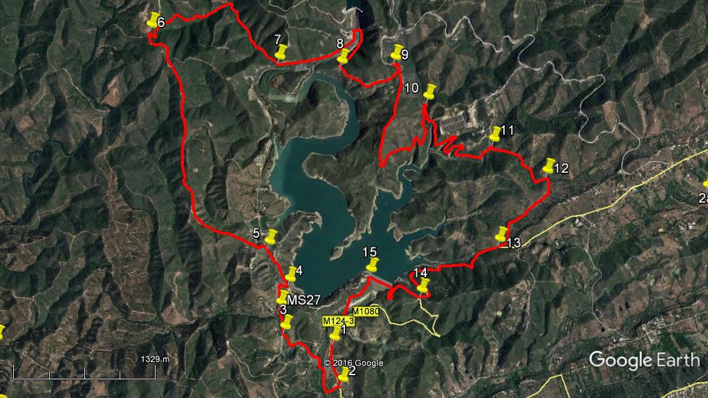
- With your back to Cafe Zé, (1) turn right and walk along the tarmac road. After 410 metres, find a turn to the right with a large shed (curved metal roof) a short way down. (2) Take this track and at the next junction after 140 metres turn right again and walk along the valley, more or less northwards. The track turns left, then right, then left again and rises gently, before coming to another right turn and beginning to rise more steeply to a junction. (960m from 2) (3). Bear right here and continue to climb, almost due north again, for around 460m until the barrage comes into sight on the right. Drop down towards it on the track to reach another junction (4).
- Turn left and walk up the broad track for around 420m, and take the left hand at a fork (5). The next stage is a long climb up a ridge. Follow the same broad track as it first of all undulates a little and then climbs more purposefully, over a distance of some 2.8k. The direction of travel is north-west at first, turning more northerly. Where the track turns more to the west again for a short distance, look for a track crossing the ridge where the left hand comes in from the south-west and the right hand turns back south-east. (6).
- Take the right hand on level ground for a short distance, then go through a hairpin left and start to descend, losing height more quickly as you go on. After around 960m the track curves quite sharply to the right and is soon joined by another coming in from the left. Continue downhill in what is now an obvious valley, reaching the valley floor at a junction after a further 770m. (7)
- Turn left here and walk along a very broad track- this was an access road used when the new Barragem do Funcho was being created. Walk round the curve to see the Funcho dam wall rising up in front. Turn right across the bridge and start to climb up the opposite side of the valley, now heading south, then south-east. At the first big bend, see a picnic area on the right (8) where lunch can be taken in relative comfort. From here, continue to climb for a further 740m, until the road levels out round a tight left-hand curve. Find a track on the right, (9) (there are often camper-vans here), turning back through 180 degrees to the road, and follow this as it quickly leaves the direction of the road and turns more due south. A short distance along, find the viewing platform from which you can look down on the lynx breeding project in the valley. There is also an information board.
- From the viewing platform continue walking due south – the track may be a little overgrown for a time. After around 840m, descending, come to a tight left-hand curve at a point where you can see the barragem ahead as well as to the side. Follow round the curve and continue to descend, heading now north-east. Work round a small valley after around half a kilometre, then turn again due north. The lynx project is now above you over to the right. About 430m from where you turned north, cross over to the other side of the valley (10) and turn southwards. Your path now passes directly below the lynx project, heading first more or less south and then, having passed below the site, winds round the heads of two deep valleys. Distance from point 10 to the end of the second valley detour is around 1.2k.
- The track now runs due east for around 230m before plunging northwards again to round a third valley-head (11), emerging from this quite quickly to turn due east again. Rising gently and undulating, the path turns more south-easterly before briefly turning north-east (12) (720m from 11.) From here it turns again, first south-east, then south-west, finally due south, rising gently to a final turn south-west to meet a tarmac road. (13) (900m)
- From here, turn right down the road and follow it for 1.33k to a junction with another road (14). Turn right to walk down to the dam wall of the barragem and walk across it. Arrive at an open tarmacked area with a stone column recalling the days before the revolution of 1974. Swing left here and walk downhill into a valley. Cross a ford at the bottom (rarely wet these days) and climb the slope following. Bear right at the junction to walk along the road back to Bar Zé where you began. (1.56k from 14).
Barragem do Arade.
Orientation normal. 37/8
GPS Points:
| 1 |
Cafe Ze |
14 |
00 |
43 |
|
22 |
47 |
16 |
|
|
| 2 |
Turn off road |
13 |
48 |
53 |
|
22 |
41 |
71 |
|
410m |
| 3 |
Right hand turn |
14 |
01 |
95 |
|
23 |
06 |
60 |
|
960m |
| 4 |
At Barragem |
14 |
16 |
72 |
|
23 |
07 |
47 |
|
560m |
| 5 |
Fork |
14 |
27 |
32 |
|
23 |
17 |
20 |
|
420m |
| 6 |
Turn off ridge |
15 |
26 |
87 |
|
24 |
12 |
39 |
|
2.82k |
| 7 |
At valley |
15 |
23 |
93 |
|
23 |
23 |
51 |
|
1.73k |
| 8 |
Picnic site |
15 |
25 |
03 |
|
22 |
59 |
59 |
|
1.42k |
| 9 |
Turn to viewpoint |
15 |
27 |
72 |
|
22 |
39 |
69 |
|
740m |
| 10 |
Hairpin turn |
15 |
17 |
88 |
|
22 |
24 |
67 |
|
2k |
| 11 |
Bend after lynx |
15 |
08 |
01 |
|
21 |
57 |
34 |
|
1.53k |
| 12 |
Before descent |
15 |
00 |
62 |
|
21 |
35 |
46 |
|
720m |
| 13 |
Joining tarmac |
14 |
37 |
93 |
|
21 |
49 |
93 |
|
900m |
| 14 |
Turn to dam |
14 |
19 |
19 |
|
22 |
16 |
75 |
|
1.33k |
| 15 |
Salazar column |
14 |
23 |
06 |
|
22 |
37 |
01 |
|
770m |
| |
End |
|
|
|
|
|
|
|
|
770m |